Country:
 Australia
Region:
City:
Latitude and Longitude:
Time Zone:
Postal Code:
IP information under different IP Channel
ip-api
Country
Region
City
ASN
Time Zone
ISP
Blacklist
Proxy
Latitude
Longitude
Postal
Route
IPinfo
Country
Region
City
ASN
Time Zone
ISP
Blacklist
Proxy
Latitude
Longitude
Postal
Route
MaxMind
Country
Region
City
ASN
Time Zone
ISP
Blacklist
Proxy
Latitude
Longitude
Postal
Route
Luminati
Country
AUASN
Time Zone
Australia/Sydney
ISP
Cynergic Internet
Latitude
Longitude
Postal
db-ip
Country
Region
City
ASN
Time Zone
ISP
Blacklist
Proxy
Latitude
Longitude
Postal
Route
ipdata
Country
Region
City
ASN
Time Zone
ISP
Blacklist
Proxy
Latitude
Longitude
Postal
Route
Popular places and events near this IP address
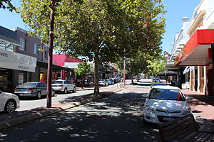
Subiaco, Western Australia
Suburb of Perth, Western Australia
Distance: Approx. 504 meters
Latitude and longitude: -31.95,115.825
Subiaco (known colloquially as Subi) is an inner-western suburb of Perth, the capital of Western Australia. It is approximately 3 km (1.9 mi) west of Perth's central business district, in the City of Subiaco local government area. Historically a working-class suburb containing a mixture of industrial and commercial land uses, since the 1990s the area has been one of Australia's most celebrated urban redevelopment projects.
Subiaco Oval
Former stadium in Perth, Western Australia
Distance: Approx. 300 meters
Latitude and longitude: -31.94444444,115.83
Subiaco Oval (; nicknamed Subi) was a sports stadium in Perth, Western Australia, located in the suburb of Subiaco. It was opened in 1908 and closed in 2017 after the completion of the new Perth Stadium in Burswood. Subiaco Oval was the highest capacity stadium in Western Australia and one of the main stadiums in Australia, with a final capacity of 43,500 people.

Subiaco railway station
Railway station in Perth, Western Australia
Distance: Approx. 533 meters
Latitude and longitude: -31.944743,115.824019
Subiaco railway station is a railway station on the Transperth network in Western Australia. It is located on the Fremantle line and Airport line, 3.7 kilometres (2.3 mi) from Perth station serving the suburbs of Subiaco and Wembley.

West Leederville railway station
Railway station in Perth, Western Australia
Distance: Approx. 615 meters
Latitude and longitude: -31.942681,115.833058
West Leederville railway station is on the Transperth network in Western Australia. It is located on the Fremantle line and Airport line, 2.7 kilometres from Perth station on the boundary between West Leederville and Subiaco. It was the main station for the former Subiaco Oval containing a special event platform no longer in use.

Nova 93.7
Radio station in Perth, Western Australia
Distance: Approx. 454 meters
Latitude and longitude: -31.9469,115.8242
Nova 93.7 (call sign: 6PER) is a commercial radio station in Perth, Western Australia. Jointly owned by NOVA Entertainment and Australian Radio Network, it was established in the Perth market on 5 December 2002. Nova 93.7 was launched at 3pm by the Red Hot Chili Peppers and by current drive presenter Tim Blackwell, with "Can't Stop" the first song being aired.
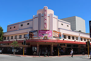
Regal Theatre, Perth
Theatre and former cinema in Subiaco, Western Australia
Distance: Approx. 491 meters
Latitude and longitude: -31.9469,115.8238
The Regal Theatre is a fine Art Deco theatre located in the suburb of Subiaco in Perth, Western Australia. It was built in 1937, and the official opening was on 27 April 1938. It was built by a wealthy grazier family Coade/Hewett, who were the grandparents and parents of the playwright Dorothy Hewett.

City of Subiaco
Local government area in Western Australia
Distance: Approx. 292 meters
Latitude and longitude: -31.949,115.827
The City of Subiaco is a local government area in Western Australia. It covers an area of approximately 7 km² in inner western metropolitan Perth and lies about 3 km west of the Perth CBD. The City includes the historically working-class suburb of Subiaco centred around Rokeby Road. Since the 1990s the area has been extensively redeveloped and gentrified.
Mueller Park
Park in Perth, Western Australia
Distance: Approx. 576 meters
Latitude and longitude: -31.9446,115.8344
Mueller Park is a park in Subiaco, Western Australia, situated next to Bob Hawke College between Perth Modern School and Subiaco Oval. It originally comprised the land area which included Subiaco Oval and in the early 1900s housed tennis, croquet, bowls, cricket and football clubs.
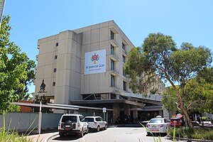
St John of God Subiaco Hospital
Hospital in Western Australia, Australia
Distance: Approx. 706 meters
Latitude and longitude: -31.94143,115.825437
St John of God Subiaco Hospital is a private hospital in Subiaco, Western Australia, founded in 1898.

St Joseph's Church, Subiaco
Church in Western Australia, Australia
Distance: Approx. 587 meters
Latitude and longitude: -31.9429,115.8251
St Joseph's Church is a Roman Catholic church in Subiaco, Western Australia. The church opened on 12 August 1934. It was designed in the Interwar Gothic style by architect Edgar Le Blond Henderson.

Bob Hawke College
School in Perth, Western Australia
Distance: Approx. 427 meters
Latitude and longitude: -31.944444,115.832365
Bob Hawke College is a public high school in the City of Subiaco and situated in the suburb of Subiaco, Western Australia. The school opened on 3 February 2020 with 250 Year 7 students, and is scheduled to expand to 1,500–2,000 students from Years 7 to 12 in 2025. The school integrates the playing surface of the former Subiaco Oval stadium, which was demolished in December 2019, into its campus.

Subiaco Hotel
Heritage listed hotel in Subiaco, Western Australia
Distance: Approx. 454 meters
Latitude and longitude: -31.9472,115.8242
The Subiaco Hotel is a historic hotel in Subiaco, Western Australia. It is located at 455–465 Hay Street, at the corner of Rokeby Road, and dates back to the state's gold rushes era of the 1890s.
Weather in this IP's area
scattered clouds
19 Celsius
18 Celsius
17 Celsius
20 Celsius
1029 hPa
60 %
1029 hPa
1026 hPa
10000 meters
3.09 m/s
180 degree
40 %
06:24:46
18:04:21