Country:
 Singapore
Region:
City:
Latitude and Longitude:
Time Zone:
Postal Code:
IP information under different IP Channel
ip-api
Country
Region
City
ASN
Time Zone
ISP
Blacklist
Proxy
Latitude
Longitude
Postal
Route
IPinfo
Country
Region
City
ASN
Time Zone
ISP
Blacklist
Proxy
Latitude
Longitude
Postal
Route
MaxMind
Country
Region
City
ASN
Time Zone
ISP
Blacklist
Proxy
Latitude
Longitude
Postal
Route
Luminati
Country
SGASN
Time Zone
Asia/Singapore
ISP
DRW-HOLDINGS
Latitude
Longitude
Postal
db-ip
Country
Region
City
ASN
Time Zone
ISP
Blacklist
Proxy
Latitude
Longitude
Postal
Route
ipdata
Country
Region
City
ASN
Time Zone
ISP
Blacklist
Proxy
Latitude
Longitude
Postal
Route
Popular places and events near this IP address

Downtown MRT station
Mass Rapid Transit station in Singapore
Distance: Approx. 248 meters
Latitude and longitude: 1.279458,103.852931
Downtown MRT station is an underground Mass Rapid Transit (MRT) station on the Downtown line (DTL). Located in Downtown Core, Singapore, underneath Central Boulevard, the station serves various commercial developments including the Marina Bay Financial Centre, Asia Square and SGX Centre. The station is operated by SBS Transit.

Shenton Way
Road in Central Area, Singapore
Distance: Approx. 82 meters
Latitude and longitude: 1.2778,103.8505
Shenton Way is a major trunk road serving Singapore's Central Area and is most commonly known for the commercial skyscrapers flanking both sides of the road. The road is a one-way street that starts at the junction of Boon Tat Street, Raffles Quay and Commerce Street before ending at Keppel Road.
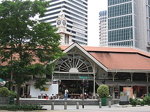
Lau Pa Sat
Historic building in Singapore used as a food centre
Distance: Approx. 264 meters
Latitude and longitude: 1.280629,103.850396
Lau Pa Sat (Chinese: 老巴刹; pinyin: Lǎo Bāshā; lit. 'Old Market'), also known as Telok Ayer Market (Malay: Pasar Telok Ayer; Chinese: 直落亚逸巴刹), is a historic building located within the Downtown Core in the Central Area of Singapore. It was first built in 1824 as a fish market on the waterfront serving the people of early colonial Singapore and rebuilt in 1838.

SGX Centre
Commercial offices in Downtown Core, Singapore
Distance: Approx. 160 meters
Latitude and longitude: 1.279042,103.84975
SGX Centre is a twin tower high-rise complex in the city of Singapore. The development consists of two 187 m (614 ft) skyscrapers, located in Shenton Way. The two towers are named SGX Centre One and SGX Centre Two, and are situated together on an elongated, rectangular site.

One Shenton Way
Residential in Downtown Core, Singapore
Distance: Approx. 114 meters
Latitude and longitude: 1.2792538,103.8505465
One Shenton is a high end real estate redevelopment project with 341 apartments along Shenton Way in the Tanjong Pagar area of Singapore. It consists of two towers, the tallest of which is 50 stories. It was completed in 2011 and is notable for its two tower construction.

UIC Building
Commercial offices in Shenton Way, Singapore
Distance: Approx. 165 meters
Latitude and longitude: 1.27791944,103.84958056
The UIC Building (United Industrial Corporation Limited Building) was a former 40-storey, 152 m (499 ft) skyscraper in the city-state of Singapore.

Asia Square
Twin-tower mixed-use development at Marina Bay, Singapore
Distance: Approx. 17 meters
Latitude and longitude: 1.27848889,103.851
Asia Square is a retail and office building located along Marina View at Marina Bay in Singapore. It is located in Marina Bay, Singapore's new business and financial precinct. It comprises 2,000,000 square feet (190,000 m2) of office space, over 30 entertainment and dining premises, as well as the largest gym in the Central Business District.

Robinson 77
Commercial offices in Robinson Road , Singapore
Distance: Approx. 311 meters
Latitude and longitude: 1.277558,103.848318
Robinson 77, formerly SIA Building, is a high-rise skyscraper located in the central business district of Singapore. The building is located on 77 Robinson Road, just next to DBS Building Tower One and Two. Once the flagship building of Singapore Airlines, the airline sold the building to SEB Investment in 2006.

Shenton Way MRT station
Mass Rapid Transit station in Singapore
Distance: Approx. 99 meters
Latitude and longitude: 1.2775,103.8507
Shenton Way MRT station is an underground Mass Rapid Transit (MRT) station on the Thomson–East Coast line (TEL). Situated in Downtown Core, Singapore, the station is near Shenton Way and commercial developments such as Asia Square and Marina One. First announced in August 2012 as part of the Thomson line (TSL), Shenton Way station was constructed as part of TEL Phase 3 (TEL 3) with the merger of the TSL and the Eastern Region line.
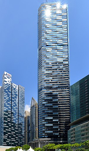
Marina Bay Suites
Condominium in Central Boulevard, Singapore
Distance: Approx. 245 meters
Latitude and longitude: 1.2803,103.852
Marina Bay Suites is a condominium in Marina Bay, Singapore. It is one of six towers of the Marina Bay Financial Centre. It was developed by Keppel Land, Cheung Kong Holdings and Hongkong Land.

Straits View
Planning Area in Central ----, Singapore
Distance: Approx. 60 meters
Latitude and longitude: 1.2787,103.8506
Straits View is a planning area located in the Central Area of the Central Region of Singapore. The area is currently relatively undeveloped, with fewer commercial developments compared to the adjacent Downtown Core. Straits View planning area is bounded by Marina South to the north, the Downtown Core to the northwest and west, and the Singapore Strait to the south.

Shenton House, Singapore
Distance: Approx. 108 meters
Latitude and longitude: 1.2787,103.8501
Shenton House is a building on Shenton Way in the Central Area of Singapore featuring a shopping podium underneath a 20-storey commercial tower. It was among the first buildings in Singapore to feature such a design.
Weather in this IP's area
light rain
30 Celsius
35 Celsius
29 Celsius
31 Celsius
1011 hPa
64 %
1011 hPa
1008 hPa
10000 meters
4.12 m/s
170 degree
75 %
06:49:11
18:54:48