203.32.39.13 - IP Lookup: Free IP Address Lookup, Postal Code Lookup, IP Location Lookup, IP ASN, Public IP
Country:
 Australia
Region:
City:
Location:
Time Zone:
Postal Code:
ISP:
ASN:
language:
User-Agent:
Proxy IP:
Blacklist:
IP information under different IP Channel
ip-api
Country
Region
City
ASN
Time Zone
ISP
Blacklist
Proxy
Latitude
Longitude
Postal
Route
db-ip
Country
Region
City
ASN
Time Zone
ISP
Blacklist
Proxy
Latitude
Longitude
Postal
Route
IPinfo
Country
Region
City
ASN
Time Zone
ISP
Blacklist
Proxy
Latitude
Longitude
Postal
Route
IP2Location
203.32.39.13Country
auRegion
victoria
City
springvale
Time Zone
Australia/Melbourne
ISP
Language
User-Agent
Latitude
Longitude
Postal
ipdata
Country
Region
City
ASN
Time Zone
ISP
Blacklist
Proxy
Latitude
Longitude
Postal
Route
Popular places and events near this IP address

Springvale, Victoria
Suburb of Melbourne, Victoria, Australia
Distance: Approx. 169 meters
Latitude and longitude: -37.947,145.153
Springvale is a suburb in Melbourne, Victoria, Australia, 22 km (14 mi) south-east of Melbourne's Central Business District, located within the City of Greater Dandenong local government area. Springvale recorded a population of 22,174 at the 2021 census. Springvale is a large suburb occupying 11.2 km2 (4.3 sq mi), bounded by Westall Road to the west, Princes Highway and Police Road to the north, the Springvale Crematorium and Corrigan Road to the northeast, Heatherton Road to the south and Lawn Road to the southeast.

Westall railway station
Railway station in Melbourne, Australia
Distance: Approx. 1707 meters
Latitude and longitude: -37.9382,145.1383
Westall railway station is a commuter railway station on the Pakenham and Cranbourne lines, which are part of the Melbourne railway network. It serves the south-eastern suburb of Clayton South, in Melbourne, Victoria, Australia. Westall station is a ground-level premium station, featuring two side platforms.

Springvale railway station
Railway station in Melbourne, Australia
Distance: Approx. 106 meters
Latitude and longitude: -37.9494,145.1531
Springvale railway station is a commuter railway station on the Pakenham and Cranbourne lines, which are part of the Melbourne railway network. It serves the south-eastern suburb of Springvale, in Melbourne, Victoria, Australia. Springvale station is a below ground premium station, featuring two side platforms.

Sandown Park railway station, Melbourne
Railway station in Melbourne, Australia
Distance: Approx. 1305 meters
Latitude and longitude: -37.9568,145.1632
Sandown Park railway station is a commuter railway station on the Pakenham and Cranbourne lines, which are part of the Melbourne railway network. It serves the south-eastern suburb of Springvale, in Melbourne, Victoria, Australia. Sandown Park station is a ground-level unstaffed station, featuring an island platform.

Sandown Racecourse
Horse racing track in Melbourne, Victoria, Australia
Distance: Approx. 1318 meters
Latitude and longitude: -37.952523,145.166817
Sandown Racecourse (currently known as Sportsbet Sandownand previously known as Ladbrokes Park due to naming rights) is a Thoroughbred horse racing race track administered by the Melbourne Racing Club in Melbourne, Victoria, Australia. It is situated 25 kilometres south-east of the Melbourne CBD on the Princes Highway in the suburb of Springvale in the City of Greater Dandenong.
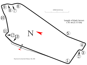
Sandown Raceway
Motorsport track in Victoria, Australia
Distance: Approx. 1301 meters
Latitude and longitude: -37.95083333,145.16722222
Sandown International Raceway is a motor racing circuit in the suburb of Springvale in Melbourne, Victoria, approximately 25 km (16 mi) south east of the city centre. Sandown is considered a power circuit with its "drag strip" front and back straights being 899 and 910 m (983 and 995 yd) long respectively.

Springvale Junction
Road intersection in Melbourne, Victoria
Distance: Approx. 1780 meters
Latitude and longitude: -37.932732,145.156088
Springvale Junction is a road intersection in Melbourne, Victoria, Australia. It is situated on the boundary of the suburbs of Mulgrave and Springvale. Springvale junction forms the intersection of four major roads, two of which terminate: Springvale Road: along with Stud Road eight kilometres to the east and Warrigal Road four kilometres to the west, Springvale Road is the busiest and most unsafe north–south thoroughfare in the eastern suburbs, with speed limits of 70 km/h and 80 km/h, and a six-lane dual carriageway.
Killester College
Independent secondary day school in Australia
Distance: Approx. 1160 meters
Latitude and longitude: -37.95888889,145.15166667
Killester College is an independent Roman Catholic secondary day school for girls, located in the Melbourne suburb of Springvale, Victoria, Australia. Killester was founded by the Brigidine Sisters. Today, Killester College works under the governance of the Kildare Ministries following Brigidine tradition.
Electoral district of Springvale
Electoral district in Australia
Distance: Approx. 290 meters
Latitude and longitude: -37.95,145.15
The electoral district of Springvale was an electoral district of the Legislative Assembly in the Australian state of Victoria. It was replaced in 2002, by the electoral districts of Lyndhurst and Mulgrave.

City of Springvale
Local government area in Victoria, Australia
Distance: Approx. 169 meters
Latitude and longitude: -37.947,145.153
The City of Springvale was a local government area about 30 kilometres (19 mi) southeast of Melbourne, the state capital of Victoria, Australia. The city covered an area of 97.60 square kilometres (37.68 sq mi), and existed from 1857 until 1994.

Minaret College
Independent co-educational school in Australia
Distance: Approx. 1170 meters
Latitude and longitude: -37.939,145.147
Minaret College is the largest co-educational Islamic school in south-eastern Melbourne, Victoria, Australia founded by Mohamed Hassan (1931 – 7 June 2020). It was established in 1992 with 22 students on the grounds of a Noble Park mosque. As enrolment began to climb a new campus was established in Springvale.
Sandown Greyhounds
Greyhound racing track in Victoria, Australia
Distance: Approx. 1102 meters
Latitude and longitude: -37.95638889,145.16027778
Sandown Greyhounds or Sandown Park is a greyhound racing track located in Springvale, Victoria, Australia. Sandown Park is operated by the Sandown Greyhound Racing Club and hosts the Melbourne Cup and the Sandown Cup. The track opened on 8 September 1956 and typically races every Thursday evening and Sunday afternoon.
Weather in this IP's area
overcast clouds
27 Celsius
28 Celsius
27 Celsius
28 Celsius
1003 hPa
52 %
1003 hPa
998 hPa
10000 meters
5.81 m/s
12.07 m/s
12 degree
100 %