Country:
Region:
City:
Latitude and Longitude:
Time Zone:
Postal Code:
IP information under different IP Channel
ip-api
Country
Region
City
ASN
Time Zone
ISP
Blacklist
Proxy
Latitude
Longitude
Postal
Route
Luminati
Country
ASN
Time Zone
Australia/Sydney
ISP
Simtronic
Latitude
Longitude
Postal
IPinfo
Country
Region
City
ASN
Time Zone
ISP
Blacklist
Proxy
Latitude
Longitude
Postal
Route
db-ip
Country
Region
City
ASN
Time Zone
ISP
Blacklist
Proxy
Latitude
Longitude
Postal
Route
ipdata
Country
Region
City
ASN
Time Zone
ISP
Blacklist
Proxy
Latitude
Longitude
Postal
Route
Popular places and events near this IP address

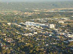
Penrith, New South Wales
City in New South Wales, Australia
Distance: Approx. 2356 meters
Latitude and longitude: -33.75111111,150.69416667
Penrith is a city in New South Wales, Australia, located in Greater Western Sydney, 55 kilometres (31 mi) west of the Sydney central business district on the banks of the Nepean River, on the outskirts of the Cumberland Plain. Its elevation is 32 metres (105 ft). Penrith is the administrative centre of the local government area of the City of Penrith.

Kingswood railway station, Sydney
Railway station in Sydney, New South Wales, Australia
Distance: Approx. 2310 meters
Latitude and longitude: -33.758255,150.720212
Kingswood railway station is located on the Main Western line, serving the Sydney suburb of Kingswood. It is served by Sydney Trains T1 Western line services.
Kingswood, New South Wales
Suburb of Sydney, New South Wales, Australia
Distance: Approx. 2242 meters
Latitude and longitude: -33.759,150.72
Kingswood is a suburb in western Sydney, in the state of New South Wales in Australia. 52 kilometres (32 mi) west of the Sydney central business district, in the local government area of the City of Penrith. There are various other locations within the state of New South Wales that are also called Kingswood, and is often confused with the nearby suburb of Kingswood Park.

South Penrith, New South Wales
Suburb of Sydney, New South Wales, Australia
Distance: Approx. 222 meters
Latitude and longitude: -33.77194444,150.70333333
South Penrith is a suburb of Sydney, in the state of New South Wales, Australia. South Penrith is located 55 kilometres west of the Sydney central business district, in the local government area of the City of Penrith and is part of the Greater Western Sydney region. South Penrith is bounded by Jamison Road to the north, York Road to the west, the M4 Motorway to the south and the Northern Road to the east.
Penrith Selective High School
School in Australia
Distance: Approx. 1755 meters
Latitude and longitude: -33.75638889,150.70638889
Penrith Selective High School (PSHS) is a public co-educational academically selective secondary day school, located in Penrith, in Western Sydney, New South Wales, Australia. Established in 1950 and operated by the NSW Department of Education, the school caters for approximately 925 students from Year 7 to Year 12. Penrith Selective High School has consistently performed among the top schools in the Higher School Certificate (HSC).

Nepean Hospital
Hospital in NSW, Australia
Distance: Approx. 1709 meters
Latitude and longitude: -33.7599,150.7131
Nepean Hospital is a 520-bed teaching hospital. providing tertiary referral services for the Nepean Blue Mountains Local Health District. Nepean Hospital is located at the base of the Blue Mountains in Kingswood, New South Wales, Australia.
St Dominic's College, Penrith
Independent secondary day school in Western Sydney, New South Wales, Australia
Distance: Approx. 2351 meters
Latitude and longitude: -33.7538297,150.714914
St Dominic's College is an independent Catholic secondary day school for boys, located in Kingswood, a subset of Penrith, a suburb in Western Sydney, New South Wales, Australia. St. Dominic's College was established in 1873 by the Congregation of Christian Brothers, who continue to run the school.
Jamison High School
School in Australia
Distance: Approx. 448 meters
Latitude and longitude: -33.775,150.69861111
Jamison High School is a public co-educational secondary day school, located in South Penrith in Western Sydney, New South Wales, Australia. The school is sited on the corner of Evan and Maxwell Streets, and stands adjacent to the Southlands Shopping Centre. As of 2020 the school has 1,124 students enrolled, ranging from Year 7 to Year 12.

Penrith Stadium
Stadium in Penrith, New South Wales, Australia
Distance: Approx. 1886 meters
Latitude and longitude: -33.75861111,150.68777778
Penrith Stadium, currently known as BlueBet Stadium for sponsorship reasons, is a rugby league and association football stadium located in Penrith, New South Wales, Australia. The 22,500 capacity venue is the home ground for the Penrith Panthers who play in the National Rugby League (NRL). The all-time attendance record for the venue is 22,582 in a match between the Panthers and their Western Sydney rivals Parramatta on 17 July 2010.
St Philip's Anglican Church, Kingswood
Church in New South Wales, Australia
Distance: Approx. 1997 meters
Latitude and longitude: -33.763,150.72
St. Phillip's Anglican Church Kingswood is an Anglican church at the corner of Bringelly Road and Second Avenue in Kingswood, a western suburb of Sydney, New South Wales, Australia. It was completed in 1896 and is a modest late-Victorian Gothic Revival building constructed in brick comprising a nave, chancel, and porch.
Penrith Cricket Club
Australian cricket club
Distance: Approx. 1926 meters
Latitude and longitude: -33.7559,150.692
Penrith Cricket Club is a cricket club based in Penrith, New South Wales, Australia. They are also known as the Panthers, and play in the Sydney Grade Cricket competition. Penrith are currently under the guidance of Andrew Lamb.

Penrith Museum of Printing
Printing museum in Penrith, New South Wales Australia
Distance: Approx. 1973 meters
Latitude and longitude: -33.7572,150.6884
The Penrith Museum of Printing is a museum in Penrith, New South Wales, Australia with a focus on Australian letterpress printing equipment and techniques.
Weather in this IP's area
clear sky
23 Celsius
23 Celsius
21 Celsius
25 Celsius
1016 hPa
41 %
1016 hPa
1010 hPa
10000 meters
5.72 m/s
8.04 m/s
132 degree
1 %
05:44:11
19:40:48