Country:
Region:
City:
Latitude and Longitude:
Time Zone:
Postal Code:
IP information under different IP Channel
ip-api
Country
Region
City
ASN
Time Zone
ISP
Blacklist
Proxy
Latitude
Longitude
Postal
Route
Luminati
Country
ASN
Time Zone
Australia/Sydney
ISP
Genisyst Pty Ltd
Latitude
Longitude
Postal
IPinfo
Country
Region
City
ASN
Time Zone
ISP
Blacklist
Proxy
Latitude
Longitude
Postal
Route
db-ip
Country
Region
City
ASN
Time Zone
ISP
Blacklist
Proxy
Latitude
Longitude
Postal
Route
ipdata
Country
Region
City
ASN
Time Zone
ISP
Blacklist
Proxy
Latitude
Longitude
Postal
Route
Popular places and events near this IP address

Mount Waverley Secondary College
School in Australia
Distance: Approx. 672 meters
Latitude and longitude: -37.86777778,145.13277778
Mount Waverley Secondary College is a public secondary school located in the Melbourne suburb of Mount Waverley. The school consists of roughly 1900 students and is one of the largest in the state. The school consists of two campuses (junior and senior) both situated on Stephensons Road in Mount Waverley.
Ashwood, Victoria
Suburb of Melbourne, Victoria, Australia
Distance: Approx. 2281 meters
Latitude and longitude: -37.867,145.103
Ashwood is a suburb in Melbourne, Victoria, Australia, 14 km south east of Melbourne's Central Business District, located within the City of Monash local government area. Ashwood recorded a population of 7,154 at the 2021 census. Ashwood was named after the suburbs of Burwood and Ashburton, because it is located between the two.
Mount Waverley, Victoria
Suburb of Melbourne, Victoria, Australia
Distance: Approx. 566 meters
Latitude and longitude: -37.877,145.131
Mount Waverley is a suburb in Melbourne, Victoria, Australia, 16 km (9.9 mi) south-east of Melbourne's Central Business District, located within the City of Monash local government area. Mount Waverley recorded a population of 35,340 at the 2021 census. It is 16 km from Melbourne at its closest point.

Jordanville railway station
Railway station in Melbourne, Australia
Distance: Approx. 1413 meters
Latitude and longitude: -37.87358,145.11199
Jordanville railway station is a commuter railway station on the Glen Waverley line, which is part of the Melbourne railway network. It serves the south-eastern suburb of Mount Waverley, in Melbourne, Victoria, Australia. Jordanville station is a ground level unstaffed station, featuring an island platform, connected by a pedestrian subway to Winsor Avenue and Huntingdale Road.

Mount Waverley railway station
Railway station in Melbourne, Australia
Distance: Approx. 311 meters
Latitude and longitude: -37.87528,145.12836
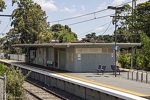
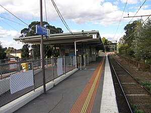
Mount Waverley railway station is a commuter railway station in the suburb of Mount Waverley in the south east of Melbourne, Victoria, Australia, and is part of the Glen Waverley line on Melbourne's suburban rail network. The station opened in 1930, as a part of the extension from Eastmalvern to Glen Waverley. The station consists of two side platforms which are connected to each other via adjacent roads and a pedestrian subway.
Syndal railway station
Railway station in Melbourne, Australia
Distance: Approx. 1922 meters
Latitude and longitude: -37.87625,145.14936
Syndal railway station is a commuter railway station on the Glen Waverley line, which is part of the Melbourne railway network. It serves the south-eastern suburb of Glen Waverley, in Melbourne, Victoria, Australia. Syndal station is a ground level unstaffed station, featuring an island platform with two faces, connected to Hunter Street and Coleman Parade via a pedestrian subway.
Syndal, Victoria
Neighbourhood in Melbourne
Distance: Approx. 1757 meters
Latitude and longitude: -37.872,145.148
Syndal is a Locality in the Melbourne suburbs of Glen Waverley and Mount Waverley in Victoria, Australia around the intersection of High Street Road and Blackburn Road. It is in the local government area of the City of Monash. From the intersection down to Syndal railway station on Coleman Parade, is the Syndal Shopping Centre.

Division of Chisholm
Australian federal electoral division
Distance: Approx. 944 meters
Latitude and longitude: -37.865,145.123
The Division of Chisholm () is an Australian Electoral Division in Victoria located in the eastern suburbs of Melbourne. The Division was created in 1949 and is named after Caroline Chisholm, a social worker and promoter of women's immigration. The Division is an Inner Metropolitan area.

Ashwood High School
Public school in Ashwood, Victoria, Australia
Distance: Approx. 2269 meters
Latitude and longitude: -37.8648,145.1041
Ashwood High School is a co-educational public school located in Ashwood, Victoria, Australia. The school offers a wide range of academic subjects and in 2016 introduced an accelerated curriculum and enrichment program (ACE). Preceding the 2022 Victorian State Election, in which the electoral district of Burwood was abolished, the school was the only secondary school in the district with an accelerated learning program.
Electoral district of Syndal
Former state electoral district of Victoria
Distance: Approx. 2039 meters
Latitude and longitude: -37.86666667,145.15
Electoral district of Syndal was an electoral district of the Legislative Assembly in the Australian state of Victoria.
Avila College
Independent, single-sex, day school in Mount Waverley, Victoria, Australia
Distance: Approx. 525 meters
Latitude and longitude: -37.8747,145.1333
Avila College is a Roman Catholic day school for girls which is located in the Melbourne suburb of Mount Waverley. The school was established in 1965 by the Presentation Sisters who accepted an invitation from the parishes in the Waverley area to establish a Catholic Girls' College. The school identifies Saint Teresa of Avila as its patron saint, from whom the Latin motto 'Filiae Ecclesiae' (Daughters of the Church) is derived.
Ashwood School, Melbourne
School in Ashwood, Victoria, Australia
Distance: Approx. 2367 meters
Latitude and longitude: -37.8592,145.107
Ashwood School is a coeducational specialist school, located on Montpellier Road, Ashwood, Victoria. It was established in 1976 and caters for students aged 5 to 18 years old with mild intellectual disabilities.
Weather in this IP's area
clear sky
14 Celsius
13 Celsius
11 Celsius
14 Celsius
1013 hPa
64 %
1013 hPa
1001 hPa
10000 meters
1.37 m/s
3.47 m/s
128 degree
10 %
06:09:09
19:56:54

