Country:
 Australia
Region:
City:
Latitude and Longitude:
Time Zone:
Postal Code:
IP information under different IP Channel
ip-api
Country
Region
City
ASN
Time Zone
ISP
Blacklist
Proxy
Latitude
Longitude
Postal
Route
IPinfo
Country
Region
City
ASN
Time Zone
ISP
Blacklist
Proxy
Latitude
Longitude
Postal
Route
MaxMind
Country
Region
City
ASN
Time Zone
ISP
Blacklist
Proxy
Latitude
Longitude
Postal
Route
Luminati
Country
AUASN
Time Zone
Australia/Sydney
ISP
Over The Wire Pty Ltd
Latitude
Longitude
Postal
db-ip
Country
Region
City
ASN
Time Zone
ISP
Blacklist
Proxy
Latitude
Longitude
Postal
Route
ipdata
Country
Region
City
ASN
Time Zone
ISP
Blacklist
Proxy
Latitude
Longitude
Postal
Route
Popular places and events near this IP address

Brisbane
Capital city of Queensland, Australia
Distance: Approx. 120 meters
Latitude and longitude: -27.46777778,153.02805556
Brisbane ( BRIZ-bən, Turrbal: Meanjin) is the capital of the state of Queensland and the third-most populous city in Australia and Oceania, with a population of over 2.7 million. Brisbane lies at the centre of South East Queensland, an urban agglomeration with a population of approximately 4 million which includes several other regional centres and cities. The central business district is situated within a peninsula of the Brisbane River about 15 km (9 mi) from its mouth at Moreton Bay.

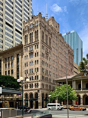
Central Plaza 1, Brisbane
Skyscraper in the city of Brisbane, Queensland, Australia
Distance: Approx. 117 meters
Latitude and longitude: -27.46706,153.0291117
Central Plaza One a skyscraper in the city of Brisbane, Queensland, Australia, was designed by renowned Japanese architect Kurokawa Kisho. The height of the tower is 174 m (571 ft) and it contains 44 floors. Construction was completed in 1988 and it became synonymous with Australian Bicentenary and World Expo '88 Brisbane.

ANZAC Square, Brisbane
Heritage-listed war memorial in Brisbane, Queensland
Distance: Approx. 140 meters
Latitude and longitude: -27.4665,153.0266
ANZAC Square is a heritage-listed town square and war memorial located between Ann Street and Adelaide Street (opposite Post Office Square), in Brisbane, Queensland, Australia. It is a state memorial to the men and women who participated in overseas armed service and is named in honour of the Australian and New Zealand Army Corps. ANZAC Square is adjacent to ANZAC Square Arcade.

Post Office Square, Brisbane
Distance: Approx. 134 meters
Latitude and longitude: -27.4679,153.0279
Post Office Square is a public square in Brisbane, Australia. It is located between Queen Street and Adelaide Street in the Brisbane CBD, and has an area of 3,300 m2. Under the square is a shopping arcade and six-level car park.

Adelaide Street, Brisbane
Street in Brisbane, Queensland
Distance: Approx. 51 meters
Latitude and longitude: -27.466774,153.027492
Adelaide Street is a major street in Brisbane, Queensland, Australia. It runs between and parallel to Queen Street and Ann Street.
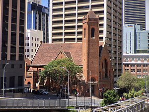
St Andrew's Uniting Church, Brisbane
Heritage-listed building in Brisbane, Queensland
Distance: Approx. 142 meters
Latitude and longitude: -27.4655,153.0275
St Andrew's Uniting Church is a heritage-listed Uniting church at 131 Creek Street (corner with Ann Street), Brisbane CBD, City of Brisbane, Queensland, Australia. It was designed by George David Payne and built in 1905 by Alexander Lind & Son. Initially St Andrew's Presbyterian Church, it became part of the Uniting Church following the merger of the Presbyterian, Methodist and Congregational Churches in 1977.
Manor Apartment Hotel
Heritage-listed hotel in Brisbane, Queensland
Distance: Approx. 115 meters
Latitude and longitude: -27.4677,153.0283
Manor Apartment Hotel is a heritage-listed former office building and now apartment hotel at 289 Queen Street, Brisbane City, City of Brisbane, Queensland, Australia. It was designed by Hennessey, Hennessey & Co and built from 1930 to 1931 by Concrete Constructions (QLD) Limited. It is also known as Colonial Mutual Life Building and Newspaper House.

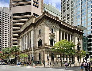
Commonwealth Government Offices, Brisbane
Heritage-listed building in Brisbane, Queensland
Distance: Approx. 95 meters
Latitude and longitude: -27.4664,153.0271
Commonwealth Government Offices is a heritage-listed office building at 232 Adelaide Street, Brisbane City, City of Brisbane, Queensland, Australia. It was designed by John Smith Murdoch and built from 1933 to 1936 by relief workers. It was added to the Queensland Heritage Register on 21 October 1992.

South African War Memorial, Brisbane
War memorial in Queensland, Australia
Distance: Approx. 129 meters
Latitude and longitude: -27.4666,153.0267
South African War Memorial is a heritage-listed memorial at ANZAC Square, 228 Adelaide Street, Brisbane City, City of Brisbane, Queensland, Australia. It was sculpted by James Laurence Watts from 1912 to 1919. It is also known as Boer War Memorial and The Scout.
National Mutual Life Building, Brisbane
Historic site in Queensland, Australia
Distance: Approx. 108 meters
Latitude and longitude: -27.4676,153.0284
National Mutual Life Building is a heritage-listed office building at 299 Queen Street, Brisbane City, City of Brisbane, Queensland, Australia. It was designed by Gibbs, Finlay & Morsby in conjunction with Thomas Blair Moncrieff Wightman and was built in 1926 by J L Green & Sons. It is also known as Metway Chambers and Custom Credit House.
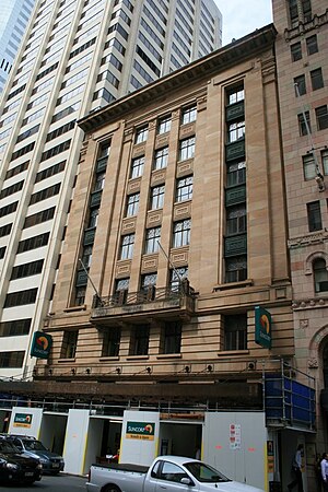
National Australia Bank (308 Queen Street)
Heritage-listed building
Distance: Approx. 39 meters
Latitude and longitude: -27.467,153.0282
National Australia Bank is a heritage-listed bank building at 308 Queen Street, Brisbane City, City of Brisbane, Queensland, Australia. It was designed by Francis Drummond Greville Stanley and built from 1881–1924 by Southall & Tracey. It is also known as Queensland National Bank.

First World War Honour Board, National Australia Bank (308 Queen Street)
Heritage-listed war memorial in Brisbane, Queensland
Distance: Approx. 39 meters
Latitude and longitude: -27.467,153.0282
First World War Honour Board is a heritage-listed memorial at the National Australia Bank, 308 Queen Street, in the Brisbane central business district, City of Brisbane, Queensland, Australia. It was added to the Queensland Heritage Register on 21 October 1992.
Weather in this IP's area
clear sky
28 Celsius
27 Celsius
26 Celsius
30 Celsius
1011 hPa
34 %
1011 hPa
1007 hPa
10000 meters
4.12 m/s
30 degree
05:39:57
17:42:54