203.24.106.105 - IP Lookup: Free IP Address Lookup, Postal Code Lookup, IP Location Lookup, IP ASN, Public IP
Country:
Region:
City:
Location:
Time Zone:
Postal Code:
ISP:
ASN:
language:
User-Agent:
Proxy IP:
Blacklist:
IP information under different IP Channel
ip-api
Country
Region
City
ASN
Time Zone
ISP
Blacklist
Proxy
Latitude
Longitude
Postal
Route
db-ip
Country
Region
City
ASN
Time Zone
ISP
Blacklist
Proxy
Latitude
Longitude
Postal
Route
IPinfo
Country
Region
City
ASN
Time Zone
ISP
Blacklist
Proxy
Latitude
Longitude
Postal
Route
IP2Location
203.24.106.105Country
Region
kosrae
City
lelu
Time Zone
Pacific/Kosrae
ISP
Language
User-Agent
Latitude
Longitude
Postal
ipdata
Country
Region
City
ASN
Time Zone
ISP
Blacklist
Proxy
Latitude
Longitude
Postal
Route
Popular places and events near this IP address

Kosrae
State in Federated States of Micronesia
Distance: Approx. 4733 meters
Latitude and longitude: 5.31666667,162.98333333
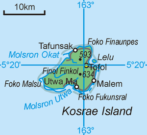
Kosrae ( koh-SHY), formerly known as Kusaie or Strong's Island, is an island and state in the Federated States of Micronesia. It includes the main island of Kosrae and a few nearby islands and islets, the most significant of which (Lelu Island) is inhabited by 1,500 people. Kosrae's land area is 110 square kilometers (42 square miles), making it the smallest state by area.
Lelu, Federated States of Micronesia
Town in Federated States of Micronesia
Distance: Approx. 156 meters
Latitude and longitude: 5.33222222,163.02277778
Lelu or Lelu Town is a municipality of the state of Kosrae, in the Federated States of Micronesia. The municipality of Lelu consists of Lelu Island (a small satellite island of Kosrae Island) and a big part of the northeastern portion of Kosrae Island. Its capital is Lelu Village, located on Lelu island.

Tafunsak
Distance: Approx. 5444 meters
Latitude and longitude: 5.3675,162.9871
Tafunsak (formerly transliterated as Tahfuhnsahk) is the largest settlement on the island of Kosrae in the Federated States of Micronesia. Its population was 2,457 at the 2000 census. This includes Walung, which had been incorporated into the municipality of Tafunsak since the 1980s.

Kosrae International Airport
Airport in Okat, the Federated States of Micronesia
Distance: Approx. 7572 meters
Latitude and longitude: 5.35694444,162.95833333
Kosrae International Airport (IATA: KSA, ICAO: PTSA, FAA LID: TTK) is an airport serving Kosrae, the easternmost state of the Federated States of Micronesia. It is located on an artificial island within the fringing reef about 150 meters from the coast and is connected to the main island by a causeway. The airport has been continuously served by the United Airlines (formerly Continental Micronesia) Island Hopper service between Guam and Honolulu, which stops twice weekly at Kosrae in each direction.

Malem, Federated States of Micronesia
Distance: Approx. 4968 meters
Latitude and longitude: 5.289,163.024
Malem, which literally translates to "Moon", is one of the five municipalities that comprise the state of Kosrae in the Federated States of Micronesia. The village gets its name from the fact that the full moon rises every month out of the ocean directly in front of the rocky beach at the edge of the village. Malem has an elementary school housing close to 400 students in grades KG-9.

Tofol
Distance: Approx. 1766 meters
Latitude and longitude: 5.32583333,163.00861111
Tofol village in Lelu Town municipality is the seat of government of the state of Kosrae in Micronesia, according to the provisions of the Kosrae State Code, Title 2, Chap. 2. It is the most easterly point of Micronesia.
Lelu Island
Island in Kosrae, Federated States of Micronesia
Distance: Approx. 1201 meters
Latitude and longitude: 5.33333333,163.03333333
Lelu Island is a small island in Lelu Harbour, in the Lelu municipality of Kosrae. It is home to the Leluh archaeological site.
Mount Finkol
Mountain in Kosrae, Micronesia
Distance: Approx. 4327 meters
Latitude and longitude: 5.3112,162.9906
Mount Finkol includes the highest point on the island of Kosrae in the Federated States of Micronesia. It rises to a height of 2064 ft (619 m).

Leluh archaeological site
United States historic place
Distance: Approx. 303 meters
Latitude and longitude: 5.3325,163.025
Leluh is a major prehistoric and historic archaeological site, encompassing the remains of a city on Lelu Island, a satellite of the larger island of Kosrae in the Federated States of Micronesia. The remains are those of a civilization that peaked around the 14th and 15th centuries, with elements still visible at the time of European contact in the early 19th century. The rulers of Leluh gradually conquered and thus unified the island of Kosrae.
Yela Ka Forest
Tree conservation area
Distance: Approx. 7959 meters
Latitude and longitude: 5.327,162.951
Yela Ka Forest is a conservation area of ka trees (Terminalia carolinensis) in the Yela Valley on the island of Kosrae in the Federated States of Micronesia. The trees are also found on the island of Pohnpei. A conservation easement, the first achieved outside the Americas, protects 78 acres (32 ha) of the 1,400 acre (570 ha) valley.
Kosrae High School
High school in Tofol, Kosrae, Federated States of Micronesia
Distance: Approx. 1682 meters
Latitude and longitude: 5.32638889,163.00916667
Kosrae High School (KHS) is a secondary school in Tofol, Lelu municipality, Kosrae State, Federated States of Micronesia. It is a part of the Kosrae State Department of Education and is the island's sole high school. It opened in the 1960s.
Kosrae State Museum
Museum in Tofol, Federated States of Micronesia
Distance: Approx. 1807 meters
Latitude and longitude: 5.32519444,163.00855556
Kosrae State Museum is a museum in Tofol in Kosrae State in the Federated States of Micronesia.
Weather in this IP's area
light rain
26 Celsius
26 Celsius
26 Celsius
26 Celsius
1008 hPa
94 %
1008 hPa
1008 hPa
10000 meters
2.06 m/s
130 degree
75 %
