203.24.105.16 - IP Lookup: Free IP Address Lookup, Postal Code Lookup, IP Location Lookup, IP ASN, Public IP
Country:
Region:
City:
Location:
Time Zone:
Postal Code:
ISP:
ASN:
language:
User-Agent:
Proxy IP:
Blacklist:
IP information under different IP Channel
ip-api
Country
Region
City
ASN
Time Zone
ISP
Blacklist
Proxy
Latitude
Longitude
Postal
Route
db-ip
Country
Region
City
ASN
Time Zone
ISP
Blacklist
Proxy
Latitude
Longitude
Postal
Route
IPinfo
Country
Region
City
ASN
Time Zone
ISP
Blacklist
Proxy
Latitude
Longitude
Postal
Route
IP2Location
203.24.105.16Country
Region
gilbert islands
City
temaiku village
Time Zone
Pacific/Tarawa
ISP
Language
User-Agent
Latitude
Longitude
Postal
ipdata
Country
Region
City
ASN
Time Zone
ISP
Blacklist
Proxy
Latitude
Longitude
Postal
Route
Popular places and events near this IP address

Bonriki International Airport
Airport in Bonriki, South Tarawa, Kiribati
Distance: Approx. 2699 meters
Latitude and longitude: 1.38166667,173.14694444
Bonriki International Airport (IATA: TRW, ICAO: NGTA) is an international airport in Kiribati, serving as the main gateway to the country. It is located in its capital, South Tarawa, which is a group of islets in the atoll of Tarawa in the Gilbert Islands, precisely on Bonriki. Fiji's national carrier, Fiji Airways connects Kiribati with Nadi, which is Fiji Airways' hub and Fiji's main international gateway.

Bikenibeu
Place in Gilbert Islands, Kiribati
Distance: Approx. 4065 meters
Latitude and longitude: 1.367,173.126
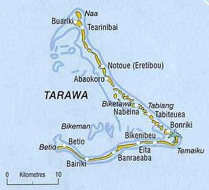
Bikenibeu is a settlement in Kiribati. It is located close to the southeastern corner of the Tarawa atoll, part of the island country of Kiribati. It is part of a nearly continuous chain of settlements along the islands of South Tarawa, which are now linked by causeways.
Te Umanibong
Museum in Kiribati
Distance: Approx. 4569 meters
Latitude and longitude: 1.36638889,173.12138889
Te Umanibong (also Te Umwanibong) or the Kiribati Cultural Museum, or Kiribati Museum and Cultural Centre, is a museum in Bikenibeu on the atoll of Tarawa in Kiribati. It displays artefacts and other items of cultural and historic significance.

Bonriki
Distance: Approx. 1505 meters
Latitude and longitude: 1.37222222,173.1525
Bonriki is a settlement on Tarawa atoll, Kiribati, near Temwaiku and is part of the municipality of South Tarawa. It is in the south-east of South Tarawa. Bonriki International Airport, one of two international airports in Kiribati, is located here.

Temwaiku
Distance: Approx. 131 meters
Latitude and longitude: 1.36388889,173.16166667
Temwaiku is a town and settlement in South Tarawa in Kiribati. It is part of a nearly continuous chain of settlements along the islands of South Tarawa, which are linked by causeways, in the same islet of Bonriki. Temwaiku had 4,072 inhabitants at the 2015 census, making it the fourth most populated area in Kiribati]and the third in South Tarawa Teinanano Urban Council (TUC), after Bikenibeu and Teaoraereke.
Weather in this IP's area
few clouds
26 Celsius
26 Celsius
26 Celsius
26 Celsius
1009 hPa
89 %
1009 hPa
1009 hPa
10000 meters
4.12 m/s
80 degree
20 %