203.24.104.142 - IP Lookup: Free IP Address Lookup, Postal Code Lookup, IP Location Lookup, IP ASN, Public IP
Country:
Region:
City:
Location:
Time Zone:
Postal Code:
IP information under different IP Channel
ip-api
Country
Region
City
ASN
Time Zone
ISP
Blacklist
Proxy
Latitude
Longitude
Postal
Route
Luminati
Country
Region
11
City
davaocity
ASN
Time Zone
Asia/Manila
ISP
Kacific Broadband Satellites Pte Ltd
Latitude
Longitude
Postal
IPinfo
Country
Region
City
ASN
Time Zone
ISP
Blacklist
Proxy
Latitude
Longitude
Postal
Route
IP2Location
203.24.104.142Country
Region
surigao del norte
City
mat-i
Time Zone
ISP
Language
User-Agent
Latitude
Longitude
Postal
db-ip
Country
Region
City
ASN
Time Zone
ISP
Blacklist
Proxy
Latitude
Longitude
Postal
Route
ipdata
Country
Region
City
ASN
Time Zone
ISP
Blacklist
Proxy
Latitude
Longitude
Postal
Route
Popular places and events near this IP address

San Francisco, Surigao del Norte
Municipality in Surigao del Norte, Philippines
Distance: Approx. 7160 meters
Latitude and longitude: 9.7778,125.4231
San Francisco, officially the Municipality of San Francisco (Surigaonon: Lungsod nan San Francisco; Tagalog: Bayan ng San Francisco), is a municipality in the province of Surigao del Norte, Philippines. According to the 2020 census, it has a population of 15,347 people.
Surigao City
Capital of Surigao del Norte, Philippines
Distance: Approx. 6790 meters
Latitude and longitude: 9.7897,125.4958
Surigao City, officially the City of Surigao (Surigaonon: Siyudad nan Surigao; Cebuano: Dakbayan sa Surigao; Filipino: Lungsod ng Surigao), is a component city and capital of the province of Surigao del Norte, Philippines. It is the most populous in the province with a population of 171,107 people according to the 2020 census. The city is located at the north-easternmost tip of Mindanao with a total land area of 245.34 km2 which is roughly 1.4% of the Caraga region.

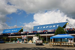
Surigao Airport
Airport in Surigao City, Philippines
Distance: Approx. 2793 meters
Latitude and longitude: 9.7575,125.47944444
Surigao Airport (IATA: SUG, ICAO: RPMS) is an airport serving the general area of Surigao City, located in the province of Surigao del Norte in the Philippines. The airport is classified as a Class 2 principal (minor domestic) airport by the Civil Aviation Authority of the Philippines, a body of the Department of Transportation that is responsible for the operations of not only this airport but also of all other airports in the Philippines except the major international airports.

Roman Catholic Diocese of Surigao
Latin Catholic diocese in the Philippines
Distance: Approx. 6722 meters
Latitude and longitude: 9.78987,125.4938
The Diocese of Surigao (Lat: Dioecesis Surigensis) is a diocese of the Latin Church of the Catholic Church in the Philippines. Erected in 1939, the diocese is one of the older ecclesiastical territories in the Philippines. The diocese was split off from the Archdiocese of Cagayan de Oro.
Caraga Regional Science High School
Public high school in Surigao del Norte, Philippines
Distance: Approx. 6151 meters
Latitude and longitude: 9.78842,125.47993
Caraga Regional Science High School is a public school in San Juan, Surigao City, Philippines. It is the leading school in the Division of Surigao City with high MPS during the annual National Achievement Tests (NAT), and has been consistent in making its name in Division, Regional, National and International level contests.
Surigao del Norte State University
Public university in Surigao del Norte, Philippines
Distance: Approx. 6476 meters
Latitude and longitude: 9.78724,125.49437
Surigao del Norte State University (SNSU), formerly the Surigao State College of Technology, is a public university in the Philippines. It is mandated to provide advance education, higher technological, professional instruction and training in the fields of agriculture and environment studies, fishery, engineering, forestry, industrial technology, education, law, medicine and other health-related programs, information technology, arts and sciences, and other related courses. It is also mandated to undertake research and extension services, and provide progressive leadership in its areas of specialization.
Caraga Regional Hospital
Government hospital in Surigao del Norte, Philippines
Distance: Approx. 5995 meters
Latitude and longitude: 9.78431,125.49002
Caraga Regional Hospital is located in Surigao City, on the northeastern tip of the Philippine island of Mindanao. The government hospital is one of at least three hospitals serving the area. The three (Caraga, Miranda Hospital and Surigao Medical Center) all are located within 1+1⁄2 miles (2.4 km) of each other on National Road, which leads from the city proper south to the city airport.
Saint Paul University Surigao
Roman Catholic university in Surigao del Norte, Philippines
Distance: Approx. 6704 meters
Latitude and longitude: 9.78956,125.49414
The Saint Paul University Surigao, also referred to as SPUS or SPU Surigao, is a private, Catholic basic and higher education institution run by the Sisters of St. Paul of Chartres (SPC) in Surigao City, Surigao del Norte, Philippines. It has two campuses: the main campus in the heart of Surigao City houses the college academic units, graduate school and offices and the satellite campus at Brgy.
St. Jude Thaddeus Institute of Technology
Private college in Surigao del Norte, Philippines
Distance: Approx. 6606 meters
Latitude and longitude: 9.78676,125.49816
St. Jude Thaddeus Institute of Technology is a private college in the Philippines. Its main campus is located along Borromeo St., Brgy Taft., Surigao City.

Surigao Cathedral
Roman Catholic church in Surigao del Norte, Philippines
Distance: Approx. 6705 meters
Latitude and longitude: 9.789722,125.49375
San Nicolas de Tolentino Cathedral, commonly known as Surigao Cathedral, is a Roman Catholic cathedral located at Surigao City in the Philippines. It is the seat of the Diocese of Surigao.
1879 Surigao earthquake
Earthquake in the Philippines
Distance: Approx. 8025 meters
Latitude and longitude: 9.8,125.5
The 1879 Surigao earthquake occurred on June 30 at 18:38 02:55 local time on the northeastern tip of Mindanao. The earthquake with a moment magnitude (Mw ) of 7.4 struck with an epicenter just south of Lake Mainit. Extensive damage occurred but there were no reports of casualties.
Weather in this IP's area
broken clouds
25 Celsius
26 Celsius
25 Celsius
25 Celsius
1012 hPa
91 %
1012 hPa
1002 hPa
10000 meters
4.08 m/s
6.91 m/s
94 degree
71 %
