203.22.108.206 - IP Lookup: Free IP Address Lookup, Postal Code Lookup, IP Location Lookup, IP ASN, Public IP
Country:
 Australia
Region:
City:
Location:
Time Zone:
Postal Code:
ISP:
ASN:
language:
User-Agent:
Proxy IP:
Blacklist:
IP information under different IP Channel
ip-api
Country
Region
City
ASN
Time Zone
ISP
Blacklist
Proxy
Latitude
Longitude
Postal
Route
db-ip
Country
Region
City
ASN
Time Zone
ISP
Blacklist
Proxy
Latitude
Longitude
Postal
Route
IPinfo
Country
Region
City
ASN
Time Zone
ISP
Blacklist
Proxy
Latitude
Longitude
Postal
Route
IP2Location
203.22.108.206Country
auRegion
australian capital territory
City
mitchell
Time Zone
Australia/Sydney
ISP
Language
User-Agent
Latitude
Longitude
Postal
ipdata
Country
Region
City
ASN
Time Zone
ISP
Blacklist
Proxy
Latitude
Longitude
Postal
Route
Popular places and events near this IP address

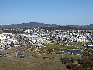
Mitchell, Australian Capital Territory
Suburb of Canberra, Australian Capital Territory
Distance: Approx. 741 meters
Latitude and longitude: -35.2192874,149.134957
Mitchell (postcode: 2911) is a light-industrial estate of Canberra, Australia in the district of Gungahlin. Mitchell was named in honour of Major Sir Thomas Livingstone Mitchell, an explorer of inland New South Wales and Surveyor-General of New South Wales. The streets in Mitchell are named after Australian industrialists.
Crace, Australian Capital Territory
Suburb of Canberra, Australian Capital Territory
Distance: Approx. 2492 meters
Latitude and longitude: -35.20222222,149.10638889
Crace () is a suburb of Canberra, Australia in the district of Gungahlin. It was named after Edward Kendall Crace an original settler in the Gungahlin area. Streets in Crace are named after parishes and land divisions from colonial times.

Franklin, Australian Capital Territory
Suburb of Canberra, Australian Capital Territory
Distance: Approx. 2012 meters
Latitude and longitude: -35.2,149.1425
Franklin (postcode: 2913) is a suburb of Canberra, Australia in the district of Gungahlin. It is named after the novelist Miles Franklin. Most streets in Franklin are named after female Australian writers.

Kenny, Australian Capital Territory
Suburb of Canberra, Australian Capital Territory
Distance: Approx. 2343 meters
Latitude and longitude: -35.213,149.155
Kenny is a designated suburb in the Canberra, Australia district of Gungahlin. The suburb is named in honour of Elizabeth Kenny, an Australian who pioneered muscle rehabilitation practices which serve as the foundation of physiotherapy. It is adjacent to the suburbs of Watson, Lyneham, the Mitchell industrial estate, Harrison and Throsby and bounded by the Federal Highway to the east and Horse Park Drive to the north.
National Folk Festival (Australia)
Music festival in Canberra, Australia
Distance: Approx. 2442 meters
Latitude and longitude: -35.231,149.147
The National Folk Festival (NFF) is held every year at Easter in the Australian capital, Canberra. First held in Melbourne in 1967, from 1969 the NFF was held in various states in city and regional venues. Since 1992 the festival had been staged at Exhibition Park in Canberra (EPIC) at Easter from Easter Thursday – Easter Monday.
Gungahlin Cemetery
Cemetery in Canberra, Australia
Distance: Approx. 703 meters
Latitude and longitude: -35.215,149.137
The Gungahlin Cemetery is a major cemetery in Canberra, the capital of Australia. It is located in Mitchell, Australian Capital Territory. The cemetery opened in 1979.

Treloar Resource Centre
Distance: Approx. 1429 meters
Latitude and longitude: -35.215,149.145
The Treloar Resource Centre, also known as the Treloar Centre and Treloar Technology Centre, is the Australian War Memorial's (AWM's) storage and conservation facility. It is located in the industrial suburb of Mitchell, Australian Capital Territory. The AWM describes the Treloar Resource Centre as "the Memorial's conservation facility and store for large objects of military technology, including aircraft, vehicles, boats, missiles and guns".
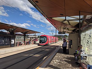
EPIC and Racecourse light rail station
Canberra Metro station
Distance: Approx. 2085 meters
Latitude and longitude: -35.2286687,149.1442876
EPIC and Racecourse is a light rail station on the Canberra Metro R1 Civic to Gungahlin line. Although technically located in the suburb of Lyneham, the station primarily serves Exhibition Park in Canberra (EPIC) - home to major annual events including Summernats, the National Folk Festival and Royal Canberra Show as well as Thoroughbred Park, the city's main venue for horse racing. The station is generally quiet outside of major events at these venues, serving the least passengers of any station on the line in the first 10 months of operation.

Well Station Drive light rail station
Distance: Approx. 1746 meters
Latitude and longitude: -35.20888889,149.14722222
Well Station Drive is a light rail station on the Canberra Metro R1 Civic to Gungahlin line, located at the intersection of Well Station Drive and Flemington Road. It serves the residential suburb of Harrison, the Shirley Smith High School in Kenny and is the closest station to many businesses in Mitchell. The station's location and lack of suitable footpaths makes access to the industrial area difficult for pedestrians, leading to safety concerns within the community.

Nullarbor Avenue light rail station
Distance: Approx. 2422 meters
Latitude and longitude: -35.20027778,149.14944444
Nullarbor Avenue is a light rail station on the Canberra Metro R1 Civic to Gungahlin line, located at the intersection of Nullarbor Avenue and Flemington Road. The station was a key location during construction and testing of the light rail route and serves the suburbs of Franklin and Harrison. A crossover track is located immediately north of the platforms, making it possible for light rail vehicles to terminate here, however currently all services continue through the station.

Sandford Street light rail station
Canberra Metro station
Distance: Approx. 1621 meters
Latitude and longitude: -35.22180278,149.14472222
Sandford Street is a light rail station in Australia on the Canberra Metro R1 Civic to Gungahlin line, located at the intersection of Flemington Road, Sandford Street and Morriset Road in Mitchell. The station serves the surrounding business and industrial precinct, and will support future residential development in the neighbouring suburb of Kenny. Bicycle racks are provided around the intersection adjacent to the station.
Canberra Racecourse
Horse racing venue in Canberra, Australia
Distance: Approx. 2196 meters
Latitude and longitude: -35.23214167,149.14010833
Canberra Racecourse, also known as Thoroughbred Park, is the major racecourse in Canberra, Australian Capital Territory, Australia. It is located in the suburb of Lyneham, 6 kilometers north of Canberra's central business district. The Thoroughbred Park turf track proper has a circumference of 1,815 metres (5,955 ft), while the smaller all-weather Acton Track, built in 2004, has a circumference of 1,597 metres (5,240 ft).
Weather in this IP's area
clear sky
17 Celsius
17 Celsius
17 Celsius
18 Celsius
1015 hPa
83 %
1015 hPa
941 hPa
10000 meters
2.18 m/s
5.24 m/s
127 degree