Country:
 Japan
JapanRegion:
City:
Latitude and Longitude:
Time Zone:
Postal Code:
IP information under different IP Channel
ip-api
Country
Region
City
ASN
Time Zone
ISP
Blacklist
Proxy
Latitude
Longitude
Postal
Route
IPinfo
Country
Region
City
ASN
Time Zone
ISP
Blacklist
Proxy
Latitude
Longitude
Postal
Route
MaxMind
Country
Region
City
ASN
Time Zone
ISP
Blacklist
Proxy
Latitude
Longitude
Postal
Route
Luminati
Country
JPRegion
40
City
fukuoka
ASN
Time Zone
Asia/Tokyo
ISP
Nagasaki Cable Media Inc.
Latitude
Longitude
Postal
db-ip
Country
Region
City
ASN
Time Zone
ISP
Blacklist
Proxy
Latitude
Longitude
Postal
Route
ipdata
Country
Region
City
ASN
Time Zone
ISP
Blacklist
Proxy
Latitude
Longitude
Postal
Route
Popular places and events near this IP address
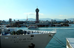
Hakata-ku, Fukuoka
Ward in Kyushu, Japan
Distance: Approx. 1720 meters
Latitude and longitude: 33.59138889,130.41472222
Hakata-ku (博多区) is a ward of the city of Fukuoka in Fukuoka Prefecture, Japan. Many of Fukuoka Prefecture and Fukuoka City's principal government, commercial, retail and entertainment establishments are located in the district. Hakata-ku is also the location of Fukuoka's main train station, Hakata Station, Fukuoka Airport and the Hakata Port international passenger ship terminal.

Fukuoka Airport
Airport serving Fukuoka–Kitakyushu, Japan
Distance: Approx. 1829 meters
Latitude and longitude: 33.58444444,130.45166667
Fukuoka Airport (福岡空港, Fukuoka Kūkō) (IATA: FUK, ICAO: RJFF), formerly known as Itazuke Air Base, is an international and domestic airport located 1.6 NM (3.0 km; 1.8 mi) east of Hakata Station in Hakata-ku, Fukuoka, Japan. The facility has one 2,800 m (9,186 ft) runway and covers 355 hectares (877 acres) of land. Fukuoka Airport is the principal airport on the island of Kyushu and is the fourth busiest passenger airport in Japan, serving 25 million passengers in 2018.

Hakata Station
Major railway and metro station in Fukuoka, Japan
Distance: Approx. 1141 meters
Latitude and longitude: 33.589803,130.420681
Hakata Station (博多駅, Hakata-eki) is a major railway station in Hakata-ku, Fukuoka, Japan. It is the largest and busiest railway terminal in Kyushu, and is a gateway to other cities in Kyushu for travelers coming from Honshu by rail travel. The San'yō Shinkansen from Osaka ends at this station.
Takeshita Station
Railway station in Fukuoka, Japan
Distance: Approx. 1904 meters
Latitude and longitude: 33.5687,130.4315
Takeshita Station (竹下駅, Takeshita-eki) is a passenger railway station located in Hakata-ku, Fukuoka, Fukuoka City, Fukuoka Prefecture, Japan. IT is operated by JR Kyushu.
Fukuoka Prefectural Fukuoka High School
Public secondary school in Fukuoka City, Fukuoka Prefecture, Japan
Distance: Approx. 1979 meters
Latitude and longitude: 33.59944444,130.41833333
Fukuoka Prefectural Fukuoka High School (福岡県立福岡高等学校, Fukuoka Kenritsu Fukuoka Kōtōgakkō) is a co-educational public senior high school located in Hakata ward, Fukuoka city, Fukuoka prefecture, Japan. It is often called "Fukkō" (福高) for short. Note, however, that there are several high schools with similar names in Saitama Prefecture in Eastern Japan and Iwate Prefecture in Northern Japan, Toyama Prefecture in central Japan.

Gion Station (Fukuoka)
Metro station in Fukuoka, Japan
Distance: Approx. 1854 meters
Latitude and longitude: 33.59416667,130.41472222
Gion Station (祇園駅, Gion-eki) is a train station located in Hakata-ku, Fukuoka in Japan. Its station symbol is a young male dressed in happi, representing the famous Hakata Gion Yamakasa, held in July each year.

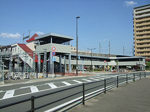
Higashi-Hie Station
Metro station in Fukuoka, Japan
Distance: Approx. 444 meters
Latitude and longitude: 33.5897,130.431
Higashi-Hie Station (東比恵駅, Higashi-Hie-eki) is a train station located in Hakata-ku, Fukuoka in Japan. The station's symbol mark is Hie's initials "ひ" looks like earthenware, because Hie remains, and "ひ"'s each edges circle mean Hakata and Airport.

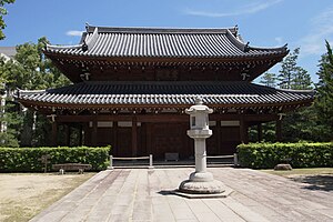
Tōchō-ji
Distance: Approx. 1946 meters
Latitude and longitude: 33.595,130.41416667
Tōchō-ji (東長寺) is a Shingon temple in Hakata, Fukuoka, Japan. Its honorary sangō prefix is Nangakuzan (南岳山). It was founded by Kūkai in 806, making it the oldest Shingon temple on the island of Kyushu.
Jōten-ji
Buddhist temple in Fukuoka Prefecture, Japan
Distance: Approx. 1751 meters
Latitude and longitude: 33.59527778,130.41694444
Jōten-ji (承天寺) is a Rinzai temple in Hakata, Fukuoka, Japan. Its honorary sangō prefix is Banshōsan (萬松山). It was founded by Enni-Ben'en upon his return from China, with support from Xie Guo Ming, a Chinese merchant.

Rakusui-en
Distance: Approx. 1732 meters
Latitude and longitude: 33.58697222,130.41338889
Rakusui-en (楽水園) is a garden in Hakata-ku, Fukuoka, Japan. It was originally built in 1906 for Shimozawa Zenemon Chikamasa, a Hakata merchant. In 1995, Fukuoka City overhauled the structure and reopened it as a Japanese garden where visitors can experience a tea ceremony; with four tea rooms (two of which are available for use by general visitors) it is often used for tea ceremonies and related training.

Sumiyoshi Shrine (Fukuoka)
Shinto shrine in Fukuoka Prefecture, Japan
Distance: Approx. 1698 meters
Latitude and longitude: 33.58590556,130.41370278
Sumiyoshi Shrine (住吉神社) is a Shinto shrine in the Sumiyoshi neighborhood of Hakata-ku, Fukuoka in Fukuoka Prefecture, Japan. It is the ichinomiya of former Chikuzen Province. The main festival of the shrine is held annually on October 13.
Hie Site
Distance: Approx. 1035 meters
Latitude and longitude: 33.57780556,130.42630556
Hie Site (比恵遺跡, Hie iseki) is a complex archeological site entered on the remains of a group of raised-floor warehouses built in the late Kofun period (6th to 7th century), located in Hakata-ku, Fukuoka, Japan. It was designated as a National Historic Site in 2001.
Weather in this IP's area
few clouds
30 Celsius
32 Celsius
29 Celsius
30 Celsius
1012 hPa
60 %
1012 hPa
1012 hPa
10000 meters
4.63 m/s
360 degree
20 %
05:57:02
18:35:17