Country:
 Bangladesh
Region:
City:
Latitude and Longitude:
Time Zone:
Postal Code:
IP information under different IP Channel
ip-api
Country
Region
City
ASN
Time Zone
ISP
Blacklist
Proxy
Latitude
Longitude
Postal
Route
IPinfo
Country
Region
City
ASN
Time Zone
ISP
Blacklist
Proxy
Latitude
Longitude
Postal
Route
MaxMind
Country
Region
City
ASN
Time Zone
ISP
Blacklist
Proxy
Latitude
Longitude
Postal
Route
Luminati
Country
BDRegion
e
City
bogra
ASN
Time Zone
Asia/Dhaka
ISP
Daffodil Online Ltd.
Latitude
Longitude
Postal
db-ip
Country
Region
City
ASN
Time Zone
ISP
Blacklist
Proxy
Latitude
Longitude
Postal
Route
ipdata
Country
Region
City
ASN
Time Zone
ISP
Blacklist
Proxy
Latitude
Longitude
Postal
Route
Popular places and events near this IP address

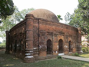
Sonargaon
Historic city in central Bangladesh
Distance: Approx. 1949 meters
Latitude and longitude: 23.6475,90.59777778
Sonargaon (Bengali: সোনারগাঁও; Bengali pronunciation: [ˈʃonaɾɡãʋ]; lit. Golden Hamlet) is a historic city in central Bangladesh. It corresponds to the Sonargaon Upazila of Narayanganj District in Dhaka Division.

Langalbandh
Distance: Approx. 5477 meters
Latitude and longitude: 23.6468,90.5631
Langalbandh (Bengali: লাঙ্গলবন্দ, literally, the place where the plough stopped), is a holy Hindu pilgrimage site located on the banks of the Brahmaputra River in Narayanganj District of Bangladesh. Punyasnan is held on the eighth tithi of Shukla Paksha of Chaitra month. At this time, many pilgrims come here for holy bath.
Sonargaon Upazila
Upazila in Dhaka, Bangladesh
Distance: Approx. 1260 meters
Latitude and longitude: 23.65833333,90.60833333
Sonargaon (Bengali: সোনারগাঁও) is an upazila of Narayanganj District in the Division of Dhaka, Bangladesh.
Marikhali Bridge
Distance: Approx. 2677 meters
Latitude and longitude: 23.6339,90.5972
Marikhali Bridge is a pair of parallel prestressed concrete girder bridges in Bangladesh. It is located along the Dhaka-Chittagong Highway, about 3.2 kilometres (2 mi) north of the more famous Meghna Bridge.
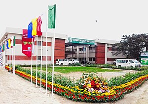
Hamdard University Bangladesh
Distance: Approx. 3930 meters
Latitude and longitude: 23.6152,90.6102
Hamdard University Bangladesh (Bengali: হামদর্দ বিশ্ববিদ্যালয় বাংলাদেশ) is a newly established private university in Bangladesh.
Baorkhola
Village in Bangladesh
Distance: Approx. 7425 meters
Latitude and longitude: 23.6177,90.6804
Dakshin Baorkhola is a village in Meghna Upazila in Comilla District, Bangladesh. It has one side flowing by a canal and other side by a straight road. There are two government primary schools and a private high school.

Panam Nagar
Ancient city in Bangladesh
Distance: Approx. 1439 meters
Latitude and longitude: 23.656,90.6042
Panam Nagar (Bengali: পানাম নগর, romanized: panam nogor, lit. 'Panam City') was an ancient settlement in Bangladesh, a portion of archaeological remains of which is situated at Sonargaon Upazila in Narayanganj District. Panam Nagar traces its origins to the 13th century. Once a thriving commercial centre, it declined in the 17th century following the relocation of the capital from Sonargaon.
Mograpara
Distance: Approx. 3514 meters
Latitude and longitude: 23.634,90.587
Mograpara is medieval settlement in Sonargaon in present-day Bangladesh. It is believed to be the oldest Muslim settlement in Sonargaon.
Mugra Para Union
Union in Dhaka Division, Narayanganj Bangladesh
Distance: Approx. 3304 meters
Latitude and longitude: 23.6343,90.5892
Mugra Para is a union parishad, the smallest administrative body of Bangladesh, located in Sonargaon Upazila, Narayanganj District, Bangladesh. The total population is 24,115.
Baidyer Bazar Union
Union in Dhaka Division, Bangladesh
Distance: Approx. 2125 meters
Latitude and longitude: 23.6669,90.6264
Baidyer Bazar Union is a union, the smallest administrative body of Bangladesh, located in Sonargaon Upazila, Narayanganj District, Bangladesh. The total population is 19,797.
Dhamgar Union
Place in Dhaka Division, Bangladesh
Distance: Approx. 8556 meters
Latitude and longitude: 23.6704,90.5358
Dhamgar Union (Bengali: ধামগড় ইউনিয়ন) is a union parishad of Bandar Upazila in Narayanganj District of the Division of Dhaka, Bangladesh. It has a population of 13,362 men and 12,848 women. The union has a literacy rate of 54.3 per cent.
Musapur Union
Place in Dhaka Division, Bangladesh
Distance: Approx. 5323 meters
Latitude and longitude: 23.6503,90.5645
Musapur Union (Bengali: মুছাপুর ইউনিয়ন) is a union parishad of Bandar Upazila in Narayanganj District of the Division of Dhaka, Bangladesh. It has a population of 13,171 men and 12,762 women. The union has a literacy rate of 47.6 per cent.
Weather in this IP's area
few clouds
31 Celsius
38 Celsius
31 Celsius
31 Celsius
1003 hPa
74 %
1003 hPa
1002 hPa
10000 meters
2.29 m/s
3.01 m/s
284 degree
16 %
05:45:16
17:57:28