Country:
Region:
City:
Latitude and Longitude:
Time Zone:
Postal Code:
IP information under different IP Channel
ip-api
Country
Region
City
ASN
Time Zone
ISP
Blacklist
Proxy
Latitude
Longitude
Postal
Route
Luminati
Country
ASN
Time Zone
Asia/Bangkok
ISP
Thailand Public backbone Network
Latitude
Longitude
Postal
IPinfo
Country
Region
City
ASN
Time Zone
ISP
Blacklist
Proxy
Latitude
Longitude
Postal
Route
db-ip
Country
Region
City
ASN
Time Zone
ISP
Blacklist
Proxy
Latitude
Longitude
Postal
Route
ipdata
Country
Region
City
ASN
Time Zone
ISP
Blacklist
Proxy
Latitude
Longitude
Postal
Route
Popular places and events near this IP address

Baiyoke Tower II
Hotel skyscraper in Bangkok, Thailand
Distance: Approx. 496 meters
Latitude and longitude: 13.754167,100.540556
Baiyoke Tower II (Thai: อาคารใบหยก 2, RTGS: Akhan Baiyok Song, pronounced [ʔāː.kʰāːn bāj.jòk sɔ̌ːŋ]) is an 88-story, 309 m (1,014 ft) skyscraper hotel at 222 Ratchaprarop Road in the Ratchathewi District of Bangkok, Thailand. It is the third tallest completed building in the city, after MahaNakhon and Magnolias Waterfront Residences at ICONSIAM. The building comprises the Baiyoke Sky Hotel, the tallest hotel in Southeast Asia and the seventh-tallest all-hotel structure in the world. With the antenna included, the building's height is 328.4 m (1,077 ft), and features a public observatory on the 77th floor, a bar called "Roof Top Bar & Music Lounge" on the 83rd floor, a 360-degree revolving roof deck on the 84th floor (309 m) and the hotel offers 673 guest rooms.

Ratchathewi district
Khet in Bangkok, Thailand
Distance: Approx. 710 meters
Latitude and longitude: 13.75888889,100.53444444
Ratchathewi (Thai: ราชเทวี, pronounced [râːt.t͡ɕʰā.tʰēː.wīː]) is a district (khet) in central Bangkok, Thailand. Clockwise from the north, its neighboring districts are Phaya Thai, Din Daeng, Huai Khwang, Watthana, Pathum Wan and Dusit.

Victory Monument (Bangkok)
Military monument in Bangkok, Thailand
Distance: Approx. 729 meters
Latitude and longitude: 13.76472222,100.53861111
Victory Monument (Thai: อนุสาวรีย์ชัยสมรภูมิ, RTGS: Anusawari Chai Samoraphum) is a military monument in Bangkok, Thailand. The monument was erected in June 1941 to commemorate the Thai victory in the Franco-Thai War. The monument is in Ratchathewi District, northeast of central Bangkok, at the center of a traffic circle at the intersection of Phahonyothin, Phaya Thai, and Ratchawithi roads.

Suan Pakkad Palace
Museum in Thailand
Distance: Approx. 435 meters
Latitude and longitude: 13.75666667,100.5375
Suan Pakkad Palace or Suan Pakkard Palace (Thai: สวนผักกาด, RTGS: Suan Phak Kat, pronounced [sǔan pʰàk kàːt]) is a museum in Bangkok, Thailand. It is located on Sri Ayutthaya Road, south of the Victory Monument. The museum has Thai antiques on display, including Ban Chiang pottery which are over 4,000 years old.
Bangkok Doll Museum
Museum in Bangkok, Thailand
Distance: Approx. 629 meters
Latitude and longitude: 13.7594,100.54676
Bangkok Doll Museum is a museum in Ratchathewi District, Bangkok, Thailand. The Bangkok Dolls Museum was established in 1957 by Khunying Thongkorn Chanthawimol, who was a renowned doll maker who trained in the Ozawa Doll School, in Tokyo, Japan. The museum has a collection of more than 400 Thai handmade dolls and the museum is recognised internationally, being the recipient of the first prize at the International Folklore Dolls Competition in Kraków, Poland in 1978.

Victory Monument BTS station
Railway station in Bangkok, Thailand
Distance: Approx. 626 meters
Latitude and longitude: 13.76274444,100.53708694
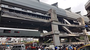
Victory Monument station (Thai: สถานีอนุสาวรีย์ชัยสมรภูมิ; RTGS: Sathani Anusaowari Chai Samoraphum) is a BTS skytrain station, on the Sukhumvit Line in Ratchathewi District, Bangkok, Thailand. The station is located on Phaya Thai Road to the south of the Victory Monument, one of the landmark and major traffic intersection of Bangkok. The station is linked to all four corners of the traffic circle by a skybridge which almost traverses around the monument.

Santiphap Park
Park in Bangkok, Thailand
Distance: Approx. 509 meters
Latitude and longitude: 13.763151,100.541489
Santiphap Park (Thai: สวนสันติภาพ, RTGS: Suan Santiphap, literally "Peace Park") is an 8-acre (0.032 km2) park in Bangkok, Thailand. It is located between Ratchawithi Road and Rang Nam Road in Ratchathewi district. The land on which Santiphap Park is built is leased from the Crown Property Bureau by the Bangkok Metropolitan Administration (BMA).

Ratchaprarop station (Airport Rail Link)
Airport Rail Link station in Bangkok, Thailand
Distance: Approx. 475 meters
Latitude and longitude: 13.7548,100.543
Ratchaprarop Station (Thai: สถานีราชปรารภ) is an Airport Rail Link station on the Ratchaprarop Road. In the future, it will become an interchange station for the MRT Orange Line following the opening of the western extension in 2030. The station serves the Pratunam area.

Makkasan
Khwaeng in Thailand
Distance: Approx. 327 meters
Latitude and longitude: 13.75599167,100.5424
Makkasan (Thai: มักกะสัน, pronounced [mák.kā.sǎn]) is the name of an intersection and the surrounding neighbourhood in Bangkok's Ratchathewi district. It is one of the 180 sub-districts in Bangkok. Makkasan Intersection is divided into two closely located intersections.
Sam Liam Din Daeng
Distance: Approx. 504 meters
Latitude and longitude: 13.76279167,100.54275556
Sam Liam Din Daeng or Din Daeng Junction (Thai: สามเหลี่ยมดินแดง, แยกดินแดง) is a road junction in the area of Thanon Phaya Thai Subdistrict, Ratchathewi District in downtown Bangkok. It is a three-way junction of Ratchawithi Road, Ratchaprarop Road and Din Daeng Road, being considered the beginning of the former two. The name of the junction refers to its triangular shape (sam liam, สามเหลี่ยม is Thai for triangle).
College of Medicine, Rangsit University
Medical school in Thailand
Distance: Approx. 668 meters
Latitude and longitude: 13.763033,100.536831
The College of Medicine, Rangsit University (Thai: วิทยาลัยแพทยศาสตร์ มหาวิทยาลัยรังสิต) is the first private medical school and the ninth oldest medical school in Thailand.

Rajavithi Hospital
Hospital in Bangkok, Thailand
Distance: Approx. 791 meters
Latitude and longitude: 13.76388889,100.53611111
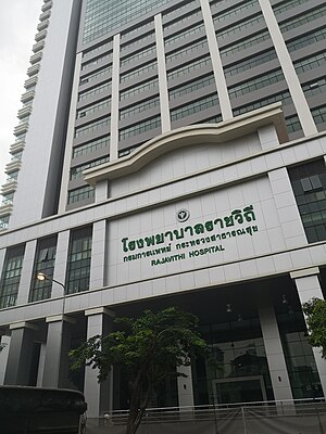
Rajavithi Hospital (Thai: โรงพยาบาลราชวิถี) is large public hospital located in Ratchathewi District, Bangkok, Thailand. It was founded in 1951 as the Women's Hospital, and is operated by the Ministry of Public Health's Department of Medical Services. With an inpatient capacity of 1,200 beds, it is one of the largest hospitals in Thailand.
Weather in this IP's area
light rain
30 Celsius
33 Celsius
30 Celsius
30 Celsius
1011 hPa
62 %
1011 hPa
1010 hPa
10000 meters
2.57 m/s
70 degree
40 %
06:14:47
17:48:26