Country:
 Hong Kong (China)
Region:
City:
Latitude and Longitude:
Time Zone:
Postal Code:
IP information under different IP Channel
ip-api
Country
Region
City
ASN
Time Zone
ISP
Blacklist
Proxy
Latitude
Longitude
Postal
Route
IPinfo
Country
Region
City
ASN
Time Zone
ISP
Blacklist
Proxy
Latitude
Longitude
Postal
Route
MaxMind
Country
Region
City
ASN
Time Zone
ISP
Blacklist
Proxy
Latitude
Longitude
Postal
Route
Luminati
Country
HKASN
Time Zone
Asia/Hong_Kong
ISP
HGC Global Communications Limited
Latitude
Longitude
Postal
db-ip
Country
Region
City
ASN
Time Zone
ISP
Blacklist
Proxy
Latitude
Longitude
Postal
Route
ipdata
Country
Region
City
ASN
Time Zone
ISP
Blacklist
Proxy
Latitude
Longitude
Postal
Route
Popular places and events near this IP address
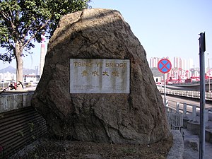
Tsing Yi South Bridge
Bridge in New Territories, Hong Kong
Distance: Approx. 172 meters
Latitude and longitude: 22.34865,114.11365
Tsing Yi South Bridge, opened as the Tsing Yi Bridge on 28 February 1974, was the first bridge to Tsing Yi, Hong Kong. It spans the Rambler Channel, linking Tsing Yi Island to the former Pillar Island, Kwai Chung. The bridge spans 610 metres (about 2,000 feet) and is 26 metres (85 feet) high.
Pillar Island
Former island of Hong Kong
Distance: Approx. 514 meters
Latitude and longitude: 22.3502,114.1166
Pillar Island or Tsing Chau was an island in the Kwai Chung area of Hong Kong, sitting at the mouth of Gin Drinkers Bay, by the side of the Rambler Channel, opposite Tsing Yi Island. In the 1960s, the bay was reclaimed and Tsing Chau became a land extension of Kwai Chung, the south of which is Kwai Tsing Container Terminals. In the early 1970s, a cross-channel bridge, Tsing Yi Bridge, was built landing on Kwai Chung where the island once was.
Tsing Yi Tong
Former lagoon in Tsing Yi, Hong Kong
Distance: Approx. 532 meters
Latitude and longitude: 22.3509,114.1076
Tsing Yi Lagoon, or Tsing Yi Tong, was a lagoon on the east shore of Tsing Yi Island in Hong Kong. Its water came from a stream in the nearby valley of Liu To and its outlet was at Tsing Yi Bay. It acted as the shelter for nearby boat people, especially after large-scale land reclamation in Tsuen Wan and Kwai Chung.
Tsing Leng Tsui
Distance: Approx. 539 meters
Latitude and longitude: 22.3527,114.1096
Tsing Leng Tsui (Chinese: 青嶺嘴) is a former cape on Tsing Yi Island, Hong Kong between the former Tsing Yi Bay and the Rambler Channel. After several phases of reclamation, the cape lost its shape and became the location of the Hong Kong Cement Plant belonging to Hong Kong Cement Manufacturing Company Limited. The area changed to a promenade and the Grand Horizon residential estate after the plant was relocated to Ngau Kok Wan (牛角灣), northwest of the island, owing to environmental concerns voiced by residents of neighbouring Greenfield Garden.

Cheung Tsing Bridge
Bridge in New Territories, Hong Kong
Distance: Approx. 189 meters
Latitude and longitude: 22.34944444,114.11344444
Cheung Tsing Bridge, formerly Rambler Channel Bridge, is a bridge crossing Rambler Channel in Hong Kong, connecting Cheung Tsing Tunnel on Tsing Yi Island and Kwai Chung section of Tsing Kwai Highway. It is part of Tsing Kwai Highway of Route 3. It is also a part of the Airport Core Programme, being a part of Route 3.
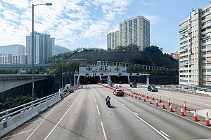
Cheung Tsing Tunnel
Distance: Approx. 43 meters
Latitude and longitude: 22.34877,114.11188
Cheung Tsing Tunnel, also spelled Cheung Ching Tunnel, is a dual tube 3-lane tunnel on Tsing Yi Island, Hong Kong. It is part of Route 3. Its east end connects to Cheung Tsing Bridge and west Cheung Tsing Highway.

Duplicate Tsing Yi South Bridge
Bridge in Hong Kong
Distance: Approx. 207 meters
Latitude and longitude: 22.34858333,114.114
Duplicate Tsing Yi South Bridge or Duplicate Tsing Yi Bridge or Kwai Tsing Bridge is a 640-metre long bridge connecting Tsing Yi Island and Kwai Chung over the Rambler Channel of Hong Kong in parallel to Tsing Yi Bridge, which deteriorated owing to years of heavy usage. The duplicated bridge was built to relieve the overburdened Tsing Yi Bridge and opened on 26 July 1999 before the commencement of Tsing Yi Bridge renovation. This is the fourth vehicular bridge connecting Kwai Chung and Tsing Yi.

Kwai Chung Incineration Plant
Incinerator in New Territories, Hong Kong
Distance: Approx. 442 meters
Latitude and longitude: 22.350999,114.115241
Kwai Chung Incineration Plant (Chinese: 葵涌焚化爐) was one of four incineration plants in Hong Kong. The plant was built on a 1.4 hectares (3.5 acres) of reclaimed land along Gin Drinkers Bay, Kwai Chung, near Pillar Island and the Rambler Channel. The plant was opened in 1978 to process solid waste from Hong Kong to reduce the need to put waste into landfills.

Tsing Yi Heung Sze Wui Road
Distance: Approx. 393 meters
Latitude and longitude: 22.35009,114.10865
Tsing Yi Heung Sze Wui Road (Chinese: 青衣鄉事會路; Cantonese Yale: ching1 yi1 heung1 si6 wui2 lou6) is one of the oldest roads on the Tsing Yi Island, Hong Kong. It was built to connect Tsing Yi Town and Tsing Yi Bridge when the bridge was being built. The name "Tsing Yi Heung Sze Wui" derives from the local Cantonese pronunciation of Tsing Yi Rural Committee.

Chan Lai So Chun Memorial School
Distance: Approx. 409 meters
Latitude and longitude: 22.3461,114.1089
The Hong Kong Sze Yap Commercial & Industrial Association Chan Lai So Chun Memorial School (Chinese: 香港四邑商工總會陳黎繡珍紀念學校) or simply Chan Lai So Chun Memorial School was a primary school founded by the Hong Kong Sze Yap Commercial & Industrial Association in Cheung Ching Estate on the Tsing Yi Island, Hong Kong.

Tsing Yi Fire Station
Oldest fire station on the Tsing Yi Island, Hong Kong
Distance: Approx. 506 meters
Latitude and longitude: 22.350956,114.107933
Tsing Yi Fire Station (Chinese: 青衣消防局) is the first fire station on the Tsing Yi Island, New Territories, Hong Kong. Located at the T-junction of Tsing Yi Heung Sze Wui Road and Cheung Wan Street on east side of the island, the station was once the sole station to cater the need for the rapid increase of population since late 1970s and the oil storage and heavy industries in the south and west. To relieve the burden of the station, a new station, Tsing Yi South Fire Station, was established in the southwest at Tsing Yi Road near Nam Wan, handling fire for industries and increasing number of oil depot.

Buddhist Yip Kei Nam Memorial College
Secondary school in Tsing Yi, Hong Kong
Distance: Approx. 356 meters
Latitude and longitude: 22.349,114.1086
Buddhist Yip Kei Nam Memorial College (Chinese: 佛敎葉紀南紀念中學) is the first secondary school on Tsing Yi Island in the New Territories of Hong Kong. Located in Cheung Ching Estate, the school was founded by Hong Kong Buddhist Association in September 1978 with buildings from Hong Kong Government and funds from Yip Hon (葉漢), a tycoon in Hong Kong and Macau. The school was named after Yip Hon's father, Yip Kei Nam (葉紀南).
Weather in this IP's area
few clouds
31 Celsius
38 Celsius
30 Celsius
32 Celsius
1015 hPa
71 %
1015 hPa
1015 hPa
10000 meters
2.24 m/s
300 degree
24 %
06:21:21
17:55:21