Country:
Region:
City:
Latitude and Longitude:
Time Zone:
Postal Code:
IP information under different IP Channel
ip-api
Country
Region
City
ASN
Time Zone
ISP
Blacklist
Proxy
Latitude
Longitude
Postal
Route
Luminati
Country
ASN
Time Zone
Asia/Karachi
ISP
NetSol Connect
Latitude
Longitude
Postal
IPinfo
Country
Region
City
ASN
Time Zone
ISP
Blacklist
Proxy
Latitude
Longitude
Postal
Route
db-ip
Country
Region
City
ASN
Time Zone
ISP
Blacklist
Proxy
Latitude
Longitude
Postal
Route
ipdata
Country
Region
City
ASN
Time Zone
ISP
Blacklist
Proxy
Latitude
Longitude
Postal
Route
Popular places and events near this IP address

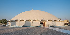
Masjid-e-Tooba
Mosque in Karachi, Pakistan
Distance: Approx. 2412 meters
Latitude and longitude: 24.84301667,67.05445
Masjid-e-Tooba or Tooba Mosque (Urdu: مسجد طوبٰی) also known as Gol Masjid, is located in the city of Karachi, Sindh the province of Pakistan. It is situated in the phase 2 of DHA (Defence Housing Authority), Karachi. The construction of the mosque began in 1966 and completed in 1969.
Mohammad Ali Jinnah University
University in Karachi, Pakistan
Distance: Approx. 440 meters
Latitude and longitude: 24.8602,67.0699
The Mohammad Ali Jinnah University (Urdu: جامعہ محمد علی جناح), abbreviated as MAJU) is a private university located in Karachi, Sindh, Pakistan. Established in 1998, the university offers undergraduate and post-graduate programs with a strong emphasis on business management, applied sciences, engineering and computer science.

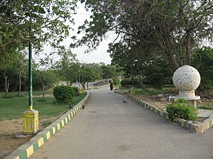
Hill Park, Karachi
Urban park in Pakistan
Distance: Approx. 1137 meters
Latitude and longitude: 24.86722222,67.07111111
Hill Park (Urdu: باغ کوہ) is situated on a hilltop surrounded by a residential area known as PECHS neighborhood of Jamshed Town in Karachi, Sindh, Pakistan. The park is spread over 62 acres (25 ha) and of this only 25% area has been developed as park.
Azam Basti
Residential neighborhood of Karachi, Pakistan
Distance: Approx. 992 meters
Latitude and longitude: 24.85,67.06666667
Azam Basti (Urdu: اعظم بستی) is a neighborhood in Karachi East district of Karachi, Pakistan. It was previously administered as part of Jamshed Town, which was disbanded in 2011. There are several ethnic groups in Azam Basti including Muhajirs, Punjabis, Sindhis, Kashmiris, Seraikis, Pakhtuns, Balochis, Memons, Bohras, Ismailis.
Chanesar Town
Neighbourhood in Karachi, Karachi East
Distance: Approx. 2416 meters
Latitude and longitude: 24.85,67.05
Chanesar Town (Urdu: چنیسر گوٹھ) is a neighborhood in Karachi East district of Karachi, Pakistan. It is led by The Pakistan Peoples Party by Chairman Mohammad Asif B and Saeed Ghani, and all of the Sindh Province. It was previously administered as part of Jamshed Town, which was disbanded in 2011.

P.E.C.H.S Block 2
Neighbourhood in Karachi, Karachi East
Distance: Approx. 1783 meters
Latitude and longitude: 24.8694,67.0613
Pakistan Employees Cooperative Housing Society (PECHS), Block 2 (biggest block of PECHS) is a neighborhood in Karachi East district of Karachi, Pakistan. It was founded by Mehmood Ahmad Nizami in the year 1950, three years after Pakistan was founded by Quaid-e-Azam Mohammad Ali Jinnah. Mehmood Ahmad Nizami lived in this same society and also created the first house in PECHS where some of his descendants now live.

Jheel Park
Park in Karachi, Pakistan
Distance: Approx. 1740 meters
Latitude and longitude: 24.8702,67.0632
The Jheel Park or Society Jheel Park (Urdu: جھیل پارک یا سوسائٹی جھیل پارک ), is situated near Tariq Road in P.E.C.H Society, Karachi, Sindh, Pakistan. The park is constructed on 25 acres (100,000 m2) of land.

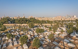
Gora Qabaristan, Karachi
Christian cemetery in Pakistan
Distance: Approx. 2299 meters
Latitude and longitude: 24.8556,67.0499
The Gora Qabaristan (Urdu: گورا قبرِستان; also spelled as Gora Kabristan), or Gora Cemetery, literally transliterated as White (man's) graveyard is Karachi, Pakistan's only operational Christian cemetery.
Abyssinia Lines
Place in Karachi, Sindh, Pakistan
Distance: Approx. 2416 meters
Latitude and longitude: 24.85,67.05
Abyssinia Lines is one of the neighbourhoods of Jamshed Town in Karachi, Sindh, Pakistan. There are several ethnic groups including Muhajirs, Punjabis, Sindhis, Kashmiris, Seraikis, Pakhtuns, Balochis, Memons, Bohras Ismailis, Baltis Nagaris commonly call Gilgitis and Christians. It is established as a refugee Colony for muhajirs.
Tabani's School of Accountancy
Distance: Approx. 1569 meters
Latitude and longitude: 24.863436,67.058722
Tabani's School of Accountancy (Urdu: تابانی اسکول آف اکاؤنٹنسی, abbreviated as: TSA) is a privately owned tertiary institution which provides professional chartered accountancy education in Karachi, Pakistan. The school has three campuses throughout Karachi, with over 4,000 students studying at three differentiated campuses located at P.E.C.H.S, North Nazimabad and Clifton.

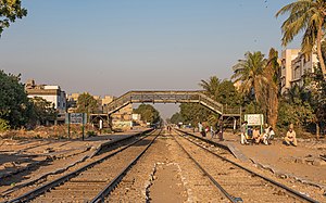
Chanesar railway station
Railway station in Pakistan
Distance: Approx. 556 meters
Latitude and longitude: 24.8573,67.0671
Chanesar Halt railway station (Urdu: چینیسر ریلوے اسٹیشن, Sindhi: چنيسر ريلوي اسٽيشن), is an abandoned train station located in Karachi, Pakistan, near the village of Chanesar Goth.

Nasla Tower
Residential building in Karachi
Distance: Approx. 1474 meters
Latitude and longitude: 24.860266,67.058425
Nasla Tower (نسلہ ٹاور) was a seventeen storey building located on Shahrah-e-Faisal, Karachi. In the encroachment case pending in the Supreme Court of Pakistan, the Supreme Court has ordered immediate demolition of Nasla Tower, a residential project in Plot No. 193 Sindhi Muslim Housing Society at the confluence of Shahra-e-Qaedin and Shahra-e-Faisal.
Weather in this IP's area
clear sky
26 Celsius
26 Celsius
26 Celsius
26 Celsius
1014 hPa
78 %
1014 hPa
1013 hPa
6000 meters
2.06 m/s
240 degree
06:43:28
17:47:31