203.170.24.46 - IP Lookup: Free IP Address Lookup, Postal Code Lookup, IP Location Lookup, IP ASN, Public IP
Country:
Region:
City:
Location:
Time Zone:
Postal Code:
IP information under different IP Channel
ip-api
Country
Region
City
ASN
Time Zone
ISP
Blacklist
Proxy
Latitude
Longitude
Postal
Route
Luminati
Country
ASN
Time Zone
Australia/Sydney
ISP
RackCorp
Latitude
Longitude
Postal
IPinfo
Country
Region
City
ASN
Time Zone
ISP
Blacklist
Proxy
Latitude
Longitude
Postal
Route
IP2Location
203.170.24.46Country
Region
queensland
City
crows nest
Time Zone
Australia/Brisbane
ISP
Language
User-Agent
Latitude
Longitude
Postal
db-ip
Country
Region
City
ASN
Time Zone
ISP
Blacklist
Proxy
Latitude
Longitude
Postal
Route
ipdata
Country
Region
City
ASN
Time Zone
ISP
Blacklist
Proxy
Latitude
Longitude
Postal
Route
Popular places and events near this IP address

Crows Nest National Park
Protected area in Queensland, Australia
Distance: Approx. 2331 meters
Latitude and longitude: -27.25388889,152.07416667
Crows Nest National Park is a national park on the edge of the Darling Downs of southern Queensland, Australia. It is divided into a number of sections which are located in both Crows Nest and Grapetree, 40 km west of Esk in the South East Queensland bioregion. A 236 ha national park was first declared in 1967.

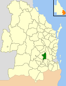
Shire of Crows Nest
Local government area in Queensland, Australia
Distance: Approx. 450 meters
Latitude and longitude: -27.26208889,152.05542222
The Shire of Crows Nest was a local government area in the Darling Downs region of Queensland, Australia, immediately northeast of the regional city of Toowoomba. The shire, administered from the town of Crows Nest, covered an area of 1,629.9 square kilometres (629.3 sq mi), and existed as a local government entity from 1913 until 2008, when it amalgamated with several other councils in the Toowoomba area to form the Toowoomba Region. Its growth in later years has been fuelled by the expansion of Toowoomba, particularly the suburbs of Highfields and Blue Mountain Heights which, with a combined population of 7,333 in 2006, were home to over half the shire's population.

Crows Nest, Queensland
Town in Queensland, Australia
Distance: Approx. 912 meters
Latitude and longitude: -27.2658,152.058
Crows Nest is a rural town and locality in the Toowoomba Region, Queensland, Australia. The town is located in the Darling Downs on the New England Highway, 158 kilometres (98 mi) from the state capital, Brisbane and 43 kilometres (27 mi) from the nearby city of Toowoomba. In the 2021 census, the locality of Crows Nest had a population of 2,212 people.
Perseverance Dam
Reservoir in km Northeast of Toowoomba, Queensland
Distance: Approx. 7229 meters
Latitude and longitude: -27.287,152.118
Perseverance Creek Dam (also known as Perseverance Dam) is a reservoir in Crows Nest, Toowoomba Region, Queensland, Australia. It creates Lake Perseverance which is the second largest (in terms of storage capacity) and the second oldest reservoir of Toowoomba city's three water supply dams. The other two storages used for Toowoomba are Cooby Dam and Cressbrook Dam which is located downstream of Perseverance.

Pechey, Queensland
Town in Queensland, Australia
Distance: Approx. 5945 meters
Latitude and longitude: -27.3133,152.0511
Pechey is a rural locality in the Toowoomba Region, Queensland, Australia. In the 2021 census, the locality of Pechey had a population of 98 people.

Crows Nest Post Office
Historic site in Queensland, Australia
Distance: Approx. 488 meters
Latitude and longitude: -27.2622,152.0558
Crows Nest Post Office is a heritage-listed post office at 19 Curnow Street, Crows Nest, Toowoomba Region, Queensland, Australia. It was built in 1911. It was added to the Queensland Heritage Register on 27 June 2003.

Pechey Forestry Arboretum
Heritage-listed forest reserve at Pechey, Toowoomba Region, Queensland, Australia
Distance: Approx. 5689 meters
Latitude and longitude: -27.311,152.0508
Pechey Forestry Arboretum is a heritage-listed forest reserve at Pechey State Forest, New England Highway, Pechey, Toowoomba Region, Queensland, Australia. It was added to the Queensland Heritage Register on 23 July 1999.

Grapetree, Queensland
Suburb of Toowoomba Region, Queensland, Australia
Distance: Approx. 8339 meters
Latitude and longitude: -27.3216,152.0994
Grapetree is a rural locality in the Toowoomba Region, Queensland, Australia. In the 2021 census, Grapetree had a population of 42 people.

Whichello, Queensland
Suburb of Toowoomba Region, Queensland, Australia
Distance: Approx. 6528 meters
Latitude and longitude: -27.2941,151.998
Whichello is a rural locality in the Toowoomba Region, Queensland, Australia. In the 2021 census, Whichello had a population of 31 people.
Pinelands, Queensland
Suburb of Toowoomba Region, Queensland, Australia
Distance: Approx. 5752 meters
Latitude and longitude: -27.2305,152.0038
Pinelands is a rural locality in the Toowoomba Region, Queensland, Australia. In the 2021 census, Pinelands had a population of 81 people.

Plainby, Queensland
Suburb of Toowoomba Region, Queensland, Australia
Distance: Approx. 8025 meters
Latitude and longitude: -27.27,151.9713
Plainby is a rural locality in the Toowoomba Region, Queensland, Australia. In the 2021 census, Plainby had a population of 56 people.
Mountain Camp, Queensland
Suburb of Toowoomba Region, Queensland, Australia
Distance: Approx. 6513 meters
Latitude and longitude: -27.203,152.0363
Mountain Camp is a rural locality in the Toowoomba Region, Queensland, Australia. In the 2021 census, Mountain Camp had a population of 24 people.
Weather in this IP's area
clear sky
18 Celsius
18 Celsius
18 Celsius
18 Celsius
1019 hPa
73 %
1019 hPa
957 hPa
10000 meters
3.16 m/s
6.93 m/s
91 degree