203.17.93.4 - IP Lookup: Free IP Address Lookup, Postal Code Lookup, IP Location Lookup, IP ASN, Public IP
Country:
 Australia
Region:
City:
Location:
Time Zone:
Postal Code:
ISP:
ASN:
language:
User-Agent:
Proxy IP:
Blacklist:
IP information under different IP Channel
ip-api
Country
Region
City
ASN
Time Zone
ISP
Blacklist
Proxy
Latitude
Longitude
Postal
Route
db-ip
Country
Region
City
ASN
Time Zone
ISP
Blacklist
Proxy
Latitude
Longitude
Postal
Route
IPinfo
Country
Region
City
ASN
Time Zone
ISP
Blacklist
Proxy
Latitude
Longitude
Postal
Route
IP2Location
203.17.93.4Country
auRegion
western australia
City
leederville
Time Zone
Australia/Perth
ISP
Language
User-Agent
Latitude
Longitude
Postal
ipdata
Country
Region
City
ASN
Time Zone
ISP
Blacklist
Proxy
Latitude
Longitude
Postal
Route
Popular places and events near this IP address
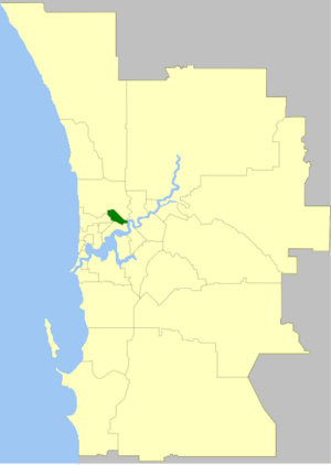
City of Vincent
Local government area in Western Australia
Distance: Approx. 748 meters
Latitude and longitude: -31.936,115.834
The City of Vincent is a local government area of Western Australia. It covers an area of approximately 10.4 square kilometres (4.0 sq mi) in metropolitan Perth, the capital of Western Australia, and lies about 3 km from the Perth CBD. The City of Vincent maintains 139 km of roads and 104 ha of parks and gardens. It had a population of over 33,000 at the 2016 Census.

Leederville, Western Australia
Suburb of Perth, Western Australia
Distance: Approx. 748 meters
Latitude and longitude: -31.936,115.834
Leederville is a suburb within the City of Vincent in the Perth metropolitan region of Western Australia. It is home to Aranmore Catholic College, the School of Isolated and Distance Education, North Metropolitan TAFE, Trinity Theological College, and St Mary's Church. The suburb was named after William Henry Leeder, the original grantee of land that encompassed the area.
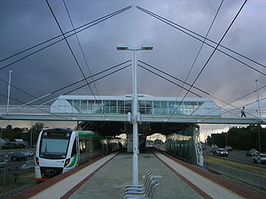
City West railway station
Railway station in West Perth, Western Australia
Distance: Approx. 988 meters
Latitude and longitude: -31.944752,115.845444
City West railway station is a railway station on the Transperth network in Western Australia. It is located on the Fremantle line and Airport line, 1.6 kilometres from Perth station serving the suburb of West Perth.

West Leederville, Western Australia
Suburb of Perth, Western Australia
Distance: Approx. 952 meters
Latitude and longitude: -31.938,115.832
West Leederville is a suburb 3 kilometres (1.9 mi) northwest of the central business district of Perth, the capital of Western Australia, and is within the Town of Cambridge. It used to be integrated with Leederville prior to the construction of the Mitchell Freeway through the suburb in 1972. The tiny section east of Southport Street is a commercial area with several warehouses, taking advantage of its location at the end of the Graham Farmer Freeway.
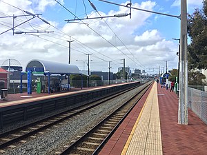
Leederville railway station
Railway station in Perth, Western Australia
Distance: Approx. 319 meters
Latitude and longitude: -31.938907,115.840273
Leederville railway station is a suburban railway station on the boundary of Leederville and West Leederville, suburbs of Perth, Western Australia. The station is on the Yanchep line and is part of the Transperth network. Located within the median strip of the Mitchell Freeway, Leederville station consists of an island platform connected to either side of the freeway by a footbridge.

Aranmore Catholic College
School in Western Australia
Distance: Approx. 974 meters
Latitude and longitude: -31.9277,115.843
The Aranmore Catholic College is a co-educational school for ages 7–12, located in Leederville in Perth, Western Australia. It was founded in 1903 by Sisters of Mercy, Mother Berchmans and Mother Aquin.
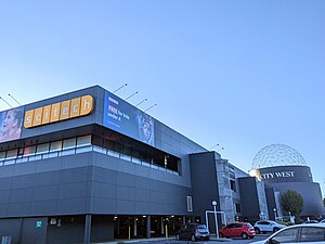
Scitech
Science museum in Perth, Western Australia
Distance: Approx. 1003 meters
Latitude and longitude: -31.9443,115.847
Scitech is a not-for-profit company encompassing the Scitech Discovery Centre, an interactive science centre in West Perth, Western Australia, outreach programs, professional learning programs and digital content. The organisation's purpose is to inspire engagement by all Western Australians in science, technology, engineering and mathematics.

Leederville Oval
Football stadium in Perth, Western Australia
Distance: Approx. 226 meters
Latitude and longitude: -31.93527778,115.84388889
Leederville Oval (known as Medibank Stadium under a naming rights agreement between 2006 and 2016) is an Australian rules football ground located in Leederville, a suburb of Perth, Western Australia. The ground is used as a home ground by two clubs: the East Perth Football Club and the Subiaco Football Club, both competing in the West Australian Football League (WAFL). The ground was previously home to the West Perth Football Club from 1915 to 1993, before the club moved to Arena Joondalup, its current home ground.

Beatty Park
Swimming pool in Perth, Western Australia
Distance: Approx. 667 meters
Latitude and longitude: -31.93555556,115.84888889
Beatty Park Leisure Centre is a swimming pool complex in the suburb of North Perth, Western Australia. Originally known as the Beatty Park Aquatic Centre, it was built for the 1962 British Empire and Commonwealth Games as the major swimming event venue, along with the Perry Lakes Stadium athletics complex. Prior to the construction of the centre, the area was part of a large reserve known as Beatty Park.

Luna Leederville
Cinema in Perth, Western Australia
Distance: Approx. 88 meters
Latitude and longitude: -31.936231,115.840985
Luna Leederville (formerly New Oxford Theatre, Nickelodeon, Olympia, Star Theatre and Luna Cinema) is a cinema complex located at the corner of Oxford and Vincent streets in Leederville, a suburb of Perth, Western Australia.

Trinity Theological College, Perth
Theological college in Leederville, Perth, Australia
Distance: Approx. 311 meters
Latitude and longitude: -31.93846,115.84413
Trinity Theological College, located in Leederville, Perth, Western Australia, is an independent theological college which provides tertiary education within the evangelical and reformed Christian traditions. Its courses are accredited through the Australian College of Theology (ACT), and range from undergraduate diplomas through to postgraduate research degrees. As a non-denominational theological college, Trinity provides education to both men and women across a range of denominations, including Anglican, Baptist, and Presbyterian.

The Nostalgia Box
Video game museum in Perth
Distance: Approx. 967 meters
Latitude and longitude: -31.9442,115.8464
The Nostalgia Box is a video game museum located in Perth, Western Australia. It is the first interactive video game console museum in Australia and was founded by Jessie Yeoh. The entire venue may be booked for private functions.
Weather in this IP's area
clear sky
23 Celsius
23 Celsius
22 Celsius
23 Celsius
1004 hPa
68 %
1004 hPa
1002 hPa
10000 meters
7.72 m/s
90 degree