Country:
 Thailand
Region:
City:
Latitude and Longitude:
Time Zone:
Postal Code:
IP information under different IP Channel
ip-api
Country
Region
City
ASN
Time Zone
ISP
Blacklist
Proxy
Latitude
Longitude
Postal
Route
IPinfo
Country
Region
City
ASN
Time Zone
ISP
Blacklist
Proxy
Latitude
Longitude
Postal
Route
MaxMind
Country
Region
City
ASN
Time Zone
ISP
Blacklist
Proxy
Latitude
Longitude
Postal
Route
Luminati
Country
THASN
Time Zone
Asia/Bangkok
ISP
T.C.C. Technology Co., Ltd.
Latitude
Longitude
Postal
db-ip
Country
Region
City
ASN
Time Zone
ISP
Blacklist
Proxy
Latitude
Longitude
Postal
Route
ipdata
Country
Region
City
ASN
Time Zone
ISP
Blacklist
Proxy
Latitude
Longitude
Postal
Route
Popular places and events near this IP address

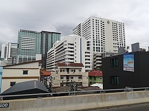
Ratchathewi district
Khet in Bangkok, Thailand
Distance: Approx. 392 meters
Latitude and longitude: 13.75888889,100.53444444
Ratchathewi (Thai: ราชเทวี, pronounced [râːt.t͡ɕʰā.tʰēː.wīː]) is a district (khet) in central Bangkok, Thailand. Clockwise from the north, its neighboring districts are Phaya Thai, Din Daeng, Huai Khwang, Watthana, Pathum Wan and Dusit.
Amnuay Silpa School
Private school in Bangkok, Thailand
Distance: Approx. 529 meters
Latitude and longitude: 13.760207,100.527787
Amnuay Silpa School (Thai: โรงเรียนอำนวยศิลป์; RTGS: Rong Rian Amnuai Sin) is a coeducational private school in Bangkok, Thailand. It teaches kindergarten, primary and secondary levels. The school was founded in 1926, formerly as an all-boy school in the early years.

Ministry of Industry (Thailand)
Distance: Approx. 638 meters
Latitude and longitude: 13.7641,100.527
The Ministry of Industry (Abrv: M-Industry; Thai: กระทรวงอุตสาหกรรม, RTGS: Krasuang Utsahakam) is a cabinet ministry in the Government of Thailand. The ministry is responsible for the promotion and regulation of industries.

Victory Monument BTS station
Railway station in Bangkok, Thailand
Distance: Approx. 518 meters
Latitude and longitude: 13.76274444,100.53708694
Victory Monument station (Thai: สถานีอนุสาวรีย์ชัยสมรภูมิ; RTGS: Sathani Anusaowari Chai Samoraphum) is a BTS skytrain station, on the Sukhumvit Line in Ratchathewi District, Bangkok, Thailand. The station is located on Phaya Thai Road to the south of the Victory Monument, one of the landmark and major traffic intersection of Bangkok. The station is linked to all four corners of the traffic circle by a skybridge which almost traverses around the monument.

Phaya Thai station
Railway station in Bangkok, Thailand
Distance: Approx. 563 meters
Latitude and longitude: 13.75694167,100.53384444
Phaya Thai station (Thai: สถานีพญาไท, pronounced [sā.tʰǎː.nīː pʰā.jāː tʰāj]) is a rapid transit station on the Airport Rail Link, BTS Sukhumvit Line and a railway halt on the Eastern Line in Ratchathewi District, Bangkok, Thailand. The Airport Rail Link station is located above the intercity Eastern Line at a level crossing on Phaya Thai Road. The station is surrounded by the government buildings, office towers and condominiums along Phaya Thai and Si Ayutthaya Road.
Armed Forces Research Institute of Medical Sciences
United States Army collaboration with the Thai Government to fight the Bangkok Cholera Outbreak
Distance: Approx. 633 meters
Latitude and longitude: 13.76656,100.53561
The Armed Forces Research Institute of Medical Sciences (AFRIMS) (Thai: สถาบันวิจัยวิทยาศาสตร์การแพทย์ทหาร) is a United States Army project that started as a collaboration with the Government of Thailand to fight a cholera outbreak in Bangkok in 1958 and 1959. It subsequently expanded to conduct military medical research, primarily involving infectious diseases, across much of Southeast Asia and the Indian Subcontinent.
Phramongkutklao Hospital
Hospital in Bangkok, Thailand
Distance: Approx. 653 meters
Latitude and longitude: 13.767407,100.534178
Phramongkutklao Hospital (Thai: โรงพยาบาลพระมงกุฎเกล้า) is a hospital located in Ratchathewi District, Bangkok, Thailand. It is a military hospital for the Royal Thai Army and a teaching hospital for Phramongkutklao College of Medicine which trains doctors for the Royal Thai Armed Forces, as well as the Royal Thai Army Nursing College.
College of Medicine, Rangsit University
Medical school in Thailand
Distance: Approx. 498 meters
Latitude and longitude: 13.763033,100.536831
The College of Medicine, Rangsit University (Thai: วิทยาลัยแพทยศาสตร์ มหาวิทยาลัยรังสิต) is the first private medical school and the ninth oldest medical school in Thailand.
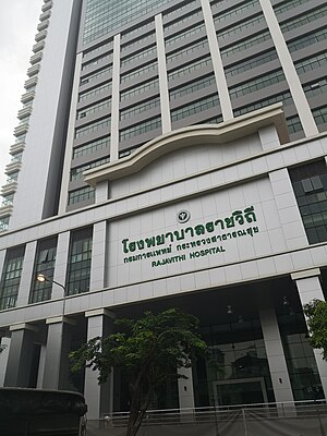
Rajavithi Hospital
Hospital in Bangkok, Thailand
Distance: Approx. 464 meters
Latitude and longitude: 13.76388889,100.53611111
Rajavithi Hospital (Thai: โรงพยาบาลราชวิถี) is large public hospital located in Ratchathewi District, Bangkok, Thailand. It was founded in 1951 as the Women's Hospital, and is operated by the Ministry of Public Health's Department of Medical Services. With an inpatient capacity of 1,200 beds, it is one of the largest hospitals in Thailand.
Queen Sirikit National Institute of Child Health
Hospital in Bangkok, Thailand
Distance: Approx. 565 meters
Latitude and longitude: 13.766079,100.535214
Queen Sirikit National Institute of Child Health (Thai: สถาบันสุขภาพเด็กแห่งชาติมหาราชินี) is large public hospital located in Ratchathewi District, Bangkok, Thailand. It serves as a teaching hospital for the College of Medicine, Rangsit University.
Hospital for Tropical Diseases (Thailand)
Hospital in Bangkok , Thailand
Distance: Approx. 536 meters
Latitude and longitude: 13.766444,100.533699
The Hospital for Tropical Diseases (Thai: โรงพยาบาลเวชศาสตร์เขตร้อน) is a hospital in Ratchathewi District, Bangkok. It is a public hospital operated by the Faculty of Tropical Medicine, Mahidol University. It specialises in tropical medicine and, since 2012, travel medicine.
Iron and Steel Institute of Thailand
Distance: Approx. 482 meters
Latitude and longitude: 13.7625,100.528
The Iron and Steel Institute of Thailand (ISIT) is a not-for-profit entity under the Foundation for Industrial Development (FID), which itself falls under the Ministry of Industry (Thailand).
Weather in this IP's area
light rain
29 Celsius
33 Celsius
28 Celsius
29 Celsius
1003 hPa
70 %
1003 hPa
1002 hPa
10000 meters
5.14 m/s
260 degree
20 %
06:06:53
18:18:02