Country:
 Thailand
Region:
City:
Latitude and Longitude:
Time Zone:
Postal Code:
IP information under different IP Channel
ip-api
Country
Region
City
ASN
Time Zone
ISP
Blacklist
Proxy
Latitude
Longitude
Postal
Route
IPinfo
Country
Region
City
ASN
Time Zone
ISP
Blacklist
Proxy
Latitude
Longitude
Postal
Route
MaxMind
Country
Region
City
ASN
Time Zone
ISP
Blacklist
Proxy
Latitude
Longitude
Postal
Route
Luminati
Country
THASN
Time Zone
Asia/Bangkok
ISP
T.C.C. Technology Co., Ltd.
Latitude
Longitude
Postal
db-ip
Country
Region
City
ASN
Time Zone
ISP
Blacklist
Proxy
Latitude
Longitude
Postal
Route
ipdata
Country
Region
City
ASN
Time Zone
ISP
Blacklist
Proxy
Latitude
Longitude
Postal
Route
Popular places and events near this IP address

Bang Kwang Central Prison
Prison in Thailand
Distance: Approx. 2196 meters
Latitude and longitude: 13.84666667,100.49305556
Bang Kwang Central Prison (Thai: เรือนจำกลางบางขวาง; RTGS: Rueancham Klang Bang Khwang) is a men's prison in Nonthaburi Province, Thailand, on the Chao Phraya River about 11 km north of Bangkok. It is a part of the Department of Corrections. Bang Kwang is the site of the men's death row and the execution chamber of Thailand.

Maha Chesadabodindranusorn Bridge
Bridge in Nonthaburi, Thailand
Distance: Approx. 593 meters
Latitude and longitude: 13.854331,100.479841
Maha Chesadabodindranusorn Bridge (Thai: สะพานมหาเจษฎาบดินทรานุสรณ์, RTGS: Saphan Mahachetsadabodinthranuson, pronounced [sa.pʰāːn ma.hǎː.t͡ɕèːt.sa.dāː.bɔ̄(ː).dīn.tʰrāː.nú.sɔ̌ːn]) is an extradosed bridge in area of Mueang Nonthaburi District in Nonthaburi Province, Thailand, over the Chao Phraya River. The bridge is the first extradosed bridge in Thailand. It is located between Phra Nangklao Bridge (upstream) and Rama V Bridge (downstream), connects Nonthaburi 1 Road, on the east side of the river, and Bang Si Mueang - Wat Bot Don Phrom Road and Ratchaphruek Road, on the west side of the river.
Central Rattanathibet
Shopping mall in Nonthaburi , Thailand
Distance: Approx. 2370 meters
Latitude and longitude: 13.866143,100.497862
Central Rattanathibet (previously known as CentralPlaza Rattanathibet) is a shopping mall located on Rattanathibet Road in Mueang Nonthaburi District, Nonthaburi.
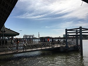
Nonthaburi Pier
Pier on the Chao Phraya River, Thailand
Distance: Approx. 2391 meters
Latitude and longitude: 13.84216667,100.49094444
Nonthaburi Pier or Nonthaburi Pier (Pibul 3) (Thai: ท่าน้ำนนทบุรี, ท่าน้ำนนทบุรี (พิบูล 3); often called short: ท่าน้ำนนท์), with designated pier number N30, is a pier on Chao Phraya River located in the Tambon Suan Yai, Amphoe Mueang Nonthaburi, Nonthaburi Province, Thailand, considered as another main pier of Nonthaburi, apart from Pak Kret Pier.

Khlong Om Non
Canal in Greater Bangkok, Thailand
Distance: Approx. 2697 meters
Latitude and longitude: 13.84465556,100.49731111
Khlong Om Non (Thai: คลองอ้อมนนท์, pronounced [kʰlɔ̄ːŋ ʔɔ̂ːm nōn]) is a branch of the Chao Phraya River in Nonthaburi Province, part of Greater Bangkok. It is now regarded as a continuation of Khlong Bangkok Noi. The khlong was originally the river's main watercourse, but became reduced when a bypass canal was dug in accordance with the orders of King Prasat Thong in the middle of the late Ayutthaya period to reduce the distance between Ayutthaya and the sea.

Wat Chaloem Phra Kiat Worawihan
Buddhist temple in Nonthaburi, Thailand
Distance: Approx. 1455 meters
Latitude and longitude: 13.8479,100.4843
Wat Chaloem Phra Kiat Worawihan (Thai: วัดเฉลิมพระเกียรติวรวิหาร; literally: "Glorify Grand Temple"), or simply known as Wat Chaloem Phra Kiat is a Thai temple in the area of Bang Si Mueang Subdistrict, Mueang Nonthaburi District, Nonthaburi Province on the Chao Phraya River, regarded as an ancient temple that is older than 160 years old. The temple is classified as the second rank of royal temple of province alike Wat Paramaiyikawat of Ko Kret. It was built in 1849 by King Nangklao (Rama III) in dedication to his mother (Queen Consort Sri Sulalai) and grandparents who resided in this area.

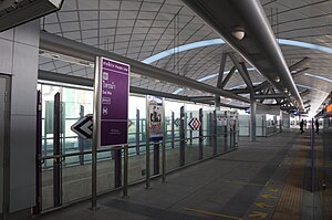
Bang Rak Noi Tha It MRT station
Bangkok MRT station on the Purple Line
Distance: Approx. 2897 meters
Latitude and longitude: 13.8748,100.4559
Bang Rak Noi Tha It station (Thai: สถานีบางรักน้อยท่าอิฐ, pronounced [sā.tʰǎː.nīː bāːŋ rák nɔ́ːj tʰâː ʔìt]) is a Bangkok MRT station on the Purple Line. The station opened on 6 August 2016 and is located on Rattanathibet road in Nonthaburi Province. The station has four entrances.
Sai Ma MRT station
Monorail station in Thailand
Distance: Approx. 1718 meters
Latitude and longitude: 13.8705,100.4666
Sai Ma station (Thai: สถานีไทรม้า, pronounced [sā.tʰǎː.nīː sāj máː]) is a Bangkok MRT station on the Purple Line. The station opened on 6 August 2016 and is located on Rattanathibet road in Nonthaburi Province. The station has four entrances.

Phra Nang Klao Bridge MRT station
Monorail station in Thailand
Distance: Approx. 1302 meters
Latitude and longitude: 13.8703,100.4803
Phra Nang Klao Bridge station (Thai: สถานีสะพานพระนั่งเกล้า, RTGS: Sathani Saphan Phra Nang Klao) is a Bangkok MRT station on the Purple Line. The station opened on 6 August 2016 and is located on Rattanathibet road on the eastern end of Phra Nang Klao Bridge crossing the Chao Phraya River in Nonthaburi Province. The station has three entrances.

Yaek Nonthaburi 1 MRT station
Monorail station Thailand
Distance: Approx. 2001 meters
Latitude and longitude: 13.8659,100.4943
Yaek Nonthaburi 1 station (Thai: สถานีแยกนนทบุรี 1, RTGS: Sathani Yaek Nonthaburi Nuang) is a Bangkok MRT station on the Purple Line. The station opened on 6 August 2016 and is located on Rattanathibet road in Nonthaburi Province. The station has four entrances.
Phra Nang Klao Hospital
Hospital in Nonthaburi , Thailand
Distance: Approx. 836 meters
Latitude and longitude: 13.865289,100.481428
Phra Nang Klao Hospital (Thai: โรงพยาบาลพระนั่งเกล้า) is the main public hospital of Nonthaburi Province, Thailand and is classified under the Ministry of Public Health as a regional hospital. It is capable of initial tertiary-level care. Its closest rapid transit station is Phra Nang Klao Bridge MRT station on the MRT Purple Line.
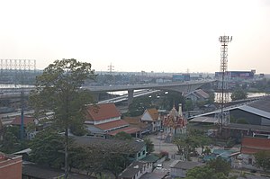
Phra Nang Klao Bridge
Bridge in Thailand
Distance: Approx. 1269 meters
Latitude and longitude: 13.870362,100.476194
Phra Nang Klao Bridge (Thai: สะพานพระนั่งเกล้า, RTGS: Saphan Phra Nangklao, pronounced [sā.pʰāːn pʰráʔ nâŋ.klâːw]) is a 4-lane bridge over Chao Phraya River in the area of Mueang Nonthaburi District, Nonthaburi Province. In addition to crossing Chao Phraya River, the bridge also connects the area between Sai Ma and Bang Kraso with Suan Yai Subdistricts together along Rattanathibet Road (Highway 302). At present, there is a 6-lane parallel bridge straddling over the bridge.
Weather in this IP's area
light rain
29 Celsius
32 Celsius
28 Celsius
29 Celsius
1003 hPa
70 %
1003 hPa
1003 hPa
10000 meters
5.14 m/s
260 degree
20 %
06:07:05
18:18:16