Country:
 Hong Kong (China)
Region:
City:
Latitude and Longitude:
Time Zone:
Postal Code:
IP information under different IP Channel
ip-api
Country
Region
City
ASN
Time Zone
ISP
Blacklist
Proxy
Latitude
Longitude
Postal
Route
IPinfo
Country
Region
City
ASN
Time Zone
ISP
Blacklist
Proxy
Latitude
Longitude
Postal
Route
MaxMind
Country
Region
City
ASN
Time Zone
ISP
Blacklist
Proxy
Latitude
Longitude
Postal
Route
Luminati
Country
HKASN
Time Zone
Asia/Hong_Kong
ISP
Hutchison Telephone Company Limited
Latitude
Longitude
Postal
db-ip
Country
Region
City
ASN
Time Zone
ISP
Blacklist
Proxy
Latitude
Longitude
Postal
Route
ipdata
Country
Region
City
ASN
Time Zone
ISP
Blacklist
Proxy
Latitude
Longitude
Postal
Route
Popular places and events near this IP address
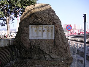
Tsing Yi South Bridge
Bridge in New Territories, Hong Kong
Distance: Approx. 513 meters
Latitude and longitude: 22.34865,114.11365
Tsing Yi South Bridge, opened as the Tsing Yi Bridge on 28 February 1974, was the first bridge to Tsing Yi, Hong Kong. It spans the Rambler Channel, linking Tsing Yi Island to the former Pillar Island, Kwai Chung. The bridge spans 610 metres (about 2,000 feet) and is 26 metres (85 feet) high.

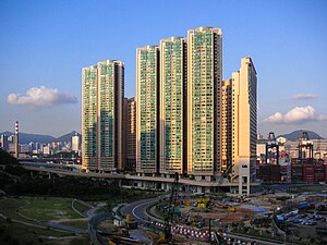
Mayfair Gardens
Distance: Approx. 520 meters
Latitude and longitude: 22.34422,114.10695
Mayfair Gardens (Chinese: 美景花園) is the first private housing estate on Tsing Yi, Hong Kong. It was built by Sun Hung Kai Properties and established between 1982 and 1984. The estate is composed of eight residential buildings, namely Blocks 5 to 12.
Rambler Crest
Housing estate in Tsing Yi, New Territories
Distance: Approx. 248 meters
Latitude and longitude: 22.34305556,114.11
Rambler Crest (Chinese: 藍澄灣) is a housing development on Tsing Yi Island, Hong Kong, which includes a private housing estate, shopping mall and 3 hotels, namely Rambler Garden Hotel (華逸酒店), Rambler Oasis Hotel (青逸酒店) and Winland 800 Hotel (永倫800酒店). It was developed by Cheung Kong Holdings. The name Rambler comes from the name of nearby channel, Rambler Channel.
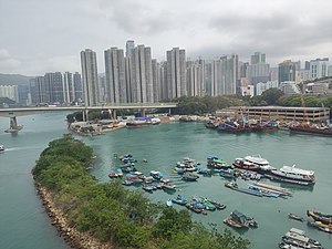
Rambler Channel Typhoon Shelter
Distance: Approx. 607 meters
Latitude and longitude: 22.3453,114.1178
Rambler Channel Typhoon Shelter (Chinese: 藍巴勒海峽避風塘) is a typhoon shelter in the Rambler Channel, near Kwai Chung, Hong Kong. It was built in 1966 with a size of 16 hectares (40 acres). In 2004 the typhoon shelter was 13 hectares (32 acres) in size.

Cheung Tsing Bridge
Bridge in New Territories, Hong Kong
Distance: Approx. 592 meters
Latitude and longitude: 22.34944444,114.11344444
Cheung Tsing Bridge, formerly Rambler Channel Bridge, is a bridge crossing Rambler Channel in Hong Kong, connecting Cheung Tsing Tunnel on Tsing Yi Island and Kwai Chung section of Tsing Kwai Highway. It is part of Tsing Kwai Highway of Route 3. It is also a part of the Airport Core Programme, being a part of Route 3.
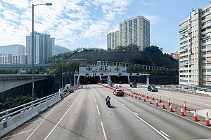
Cheung Tsing Tunnel
Distance: Approx. 498 meters
Latitude and longitude: 22.34877,114.11188
Cheung Tsing Tunnel, also spelled Cheung Ching Tunnel, is a dual tube 3-lane tunnel on Tsing Yi Island, Hong Kong. It is part of Route 3. Its east end connects to Cheung Tsing Bridge and west Cheung Tsing Highway.

Duplicate Tsing Yi South Bridge
Bridge in Hong Kong
Distance: Approx. 519 meters
Latitude and longitude: 22.34858333,114.114
Duplicate Tsing Yi South Bridge or Duplicate Tsing Yi Bridge or Kwai Tsing Bridge is a 640-metre long bridge connecting Tsing Yi Island and Kwai Chung over the Rambler Channel of Hong Kong in parallel to Tsing Yi Bridge, which deteriorated owing to years of heavy usage. The duplicated bridge was built to relieve the overburdened Tsing Yi Bridge and opened on 26 July 1999 before the commencement of Tsing Yi Bridge renovation. This is the fourth vehicular bridge connecting Kwai Chung and Tsing Yi.

Tsing Yi Heung Sze Wui Road
Distance: Approx. 731 meters
Latitude and longitude: 22.35009,114.10865
Tsing Yi Heung Sze Wui Road (Chinese: 青衣鄉事會路; Cantonese Yale: ching1 yi1 heung1 si6 wui2 lou6) is one of the oldest roads on the Tsing Yi Island, Hong Kong. It was built to connect Tsing Yi Town and Tsing Yi Bridge when the bridge was being built. The name "Tsing Yi Heung Sze Wui" derives from the local Cantonese pronunciation of Tsing Yi Rural Committee.

Chan Lai So Chun Memorial School
Distance: Approx. 377 meters
Latitude and longitude: 22.3461,114.1089
The Hong Kong Sze Yap Commercial & Industrial Association Chan Lai So Chun Memorial School (Chinese: 香港四邑商工總會陳黎繡珍紀念學校) or simply Chan Lai So Chun Memorial School was a primary school founded by the Hong Kong Sze Yap Commercial & Industrial Association in Cheung Ching Estate on the Tsing Yi Island, Hong Kong.

Buddhist Yip Kei Nam Memorial College
Secondary school in Tsing Yi, Hong Kong
Distance: Approx. 630 meters
Latitude and longitude: 22.349,114.1086
Buddhist Yip Kei Nam Memorial College (Chinese: 佛敎葉紀南紀念中學) is the first secondary school on Tsing Yi Island in the New Territories of Hong Kong. Located in Cheung Ching Estate, the school was founded by Hong Kong Buddhist Association in September 1978 with buildings from Hong Kong Government and funds from Yip Hon (葉漢), a tycoon in Hong Kong and Macau. The school was named after Yip Hon's father, Yip Kei Nam (葉紀南).

Sai Shan Village
Distance: Approx. 620 meters
Latitude and longitude: 22.3438,114.106
Sai Shan Village is a village on Tsing Yi Island, Hong Kong. The village was beneath the valley of Sai Shan and Tsing Yi Peak near Mayfair Gardens and the Hong Kong Institute of Vocational Education (Tsing Yi). A stream runs from the valley was water source for agriculture in the village.

Technological and Higher Education Institute of Hong Kong
Public college in Hong Kong
Distance: Approx. 632 meters
Latitude and longitude: 22.341,114.107
The Technological and Higher Education Institute of Hong Kong (THEi) is a public vocational college in Chai Wan, Hong Kong Island, Hong Kong. The institute is a member institution of the Vocational Training Council, a public institution provides vocationally-oriented bachelor's degree programmes for HKDSE candidates. Programmes offered by the six departments featuring a fine balance of theory, practice and general education with a focus on real-life projects and industrial attachments to develop competent professionals for the industry.
Weather in this IP's area
light rain
29 Celsius
35 Celsius
27 Celsius
30 Celsius
1008 hPa
86 %
1008 hPa
1008 hPa
10000 meters
2.68 m/s
100 degree
100 %
06:08:30
18:34:22