Country:
Region:
City:
Latitude and Longitude:
Time Zone:
Postal Code:
IP information under different IP Channel
ip-api
Country
Region
City
ASN
Time Zone
ISP
Blacklist
Proxy
Latitude
Longitude
Postal
Route
Luminati
Country
ASN
Time Zone
Australia/Sydney
ISP
Field Solutions Group Pty Ltd
Latitude
Longitude
Postal
IPinfo
Country
Region
City
ASN
Time Zone
ISP
Blacklist
Proxy
Latitude
Longitude
Postal
Route
db-ip
Country
Region
City
ASN
Time Zone
ISP
Blacklist
Proxy
Latitude
Longitude
Postal
Route
ipdata
Country
Region
City
ASN
Time Zone
ISP
Blacklist
Proxy
Latitude
Longitude
Postal
Route
Popular places and events near this IP address

Silverdome (Launceston)
Distance: Approx. 730 meters
Latitude and longitude: -41.47527778,147.14
The Silverdome, Australia's first indoor velodrome, is an indoor sporting and entertainment venue located in Launceston, Tasmania built in 1984. The capacity of the venue is 5,000.

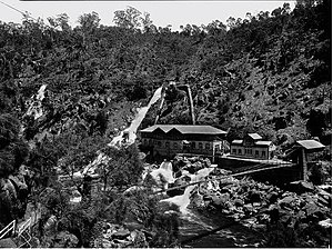
Duck Reach Power Station
Former power station in Launceston, Tasmania,
Distance: Approx. 2289 meters
Latitude and longitude: -41.45916667,147.11111111
Duck Reach Power Station was the first publicly owned hydro-electric plant in the Southern Hemisphere, and provided the Tasmanian city of Launceston with hydro-electric power from its construction in 1895 to its closure in 1955.
Summerhill, Tasmania
Suburb of Launceston, Tasmania, Australia
Distance: Approx. 535 meters
Latitude and longitude: -41.467,147.1296
Summerhill is a residential locality in the local government areas (LGA) of Launceston (96%) and Meander Valley (4%) in the Launceston LGA region of Tasmania. The locality is about 6 kilometres (3.7 mi) south of the town of Launceston. The 2016 census recorded a population of 3135 for the state suburb of Summerhill.
South Esk River
River in Tasmania, Australia
Distance: Approx. 2702 meters
Latitude and longitude: -41.45,147.11666667
The South Esk River, the longest river in Tasmania, is a major perennial river located in the northern region of Tasmania, Australia.
St Patrick's College, Launceston
Independent, day school in Prospect Vale, Launceston, Tasmania, Australia
Distance: Approx. 685 meters
Latitude and longitude: -41.4736,147.1269
St Patrick's College is a coeducational Catholic secondary school located in Launceston, Tasmania. The college has close to 1500 students enrolled and caters to Years 7 to 12.
Kings Meadows High School
School in Launceston, Tasmania, Australia
Distance: Approx. 2191 meters
Latitude and longitude: -41.47333333,147.16
Kings Meadows High School is a government co-educational comprehensive secondary school located in Kings Meadows, a southern suburb of Launceston, Tasmania, Australia. Established in 1960, the school caters to approximately 550 students from Years 7 to 12. The school is administered by the Tasmanian Department of Education.
South Launceston, Tasmania
Suburb of Launceston, Tasmania, Australia
Distance: Approx. 1986 meters
Latitude and longitude: -41.4548,147.1453
South Launceston is a residential locality in the local government area (LGA) of Launceston in the Launceston LGA region of Tasmania. The locality is about 3 kilometres (1.9 mi) south of the town of Launceston. The 2016 census recorded a population of 4592 for the state suburb of South Launceston.

Kings Meadows, Tasmania
Suburb of Launceston, Tasmania, Australia
Distance: Approx. 2427 meters
Latitude and longitude: -41.4706,147.1631
Kings Meadows is a residential locality in the local government area (LGA) of Launceston in the Launceston LGA region of Tasmania. The locality is about 5 kilometres (3.1 mi) south of the town of Launceston. The 2016 census has a population of 3670 for the state suburb of Kings Meadows.
West Launceston, Tasmania
Suburb of Launceston, Tasmania, Australia
Distance: Approx. 2196 meters
Latitude and longitude: -41.45111111,147.12916667
West Launceston is a residential locality in the local government area (LGA) of Launceston in the Launceston LGA region of Tasmania. The locality is about 3 kilometres (1.9 mi) south-west of the town of Launceston. The 2016 census recorded a population of 4212 for the state suburb of West Launceston.
Prospect, Tasmania
Suburb of Launceston, Tasmania, Australia
Distance: Approx. 8 meters
Latitude and longitude: -41.4705,147.1339
Prospect is a residential locality in the local government area (LGA) of Launceston in the Launceston LGA region of Tasmania. The locality is about 8 kilometres (5.0 mi) south of the town of Launceston. The 2016 census recorded a population of 1722 for the state suburb of Prospect.
Prospect Vale, Tasmania
Suburb of Launceston, Tasmania, Australia
Distance: Approx. 1453 meters
Latitude and longitude: -41.4753,147.1178
Prospect Vale is a rural/residential locality in the local government areas (LGA) of Launceston (1%) and Meander Valley (99%) in the Launceston LGA region of Tasmania. The locality is about 7 kilometres (4.3 mi) south-west of the town of Launceston. The 2016 census recorded a population of 5067 for the state suburb of Prospect Vale.
Youngtown Barracks
Distance: Approx. 2629 meters
Latitude and longitude: -41.4784,147.1637
Youngtown Barracks is an Australian Defence Force barracks in central Launceston, Tasmania.
Weather in this IP's area
overcast clouds
11 Celsius
10 Celsius
11 Celsius
13 Celsius
1024 hPa
71 %
1024 hPa
1005 hPa
10000 meters
7.72 m/s
150 degree
100 %
05:42:30
20:09:49
