203.131.71.29 - IP Lookup: Free IP Address Lookup, Postal Code Lookup, IP Location Lookup, IP ASN, Public IP
Country:
 The Philippines
Region:
City:
Location:
Time Zone:
Postal Code:
ISP:
ASN:
language:
User-Agent:
Proxy IP:
Blacklist:
IP information under different IP Channel
ip-api
Country
Region
City
ASN
Time Zone
ISP
Blacklist
Proxy
Latitude
Longitude
Postal
Route
db-ip
Country
Region
City
ASN
Time Zone
ISP
Blacklist
Proxy
Latitude
Longitude
Postal
Route
IPinfo
Country
Region
City
ASN
Time Zone
ISP
Blacklist
Proxy
Latitude
Longitude
Postal
Route
IP2Location
203.131.71.29Country
phRegion
rizal
City
rodriguez
Time Zone
Asia/Manila
ISP
Language
User-Agent
Latitude
Longitude
Postal
ipdata
Country
Region
City
ASN
Time Zone
ISP
Blacklist
Proxy
Latitude
Longitude
Postal
Route
Popular places and events near this IP address

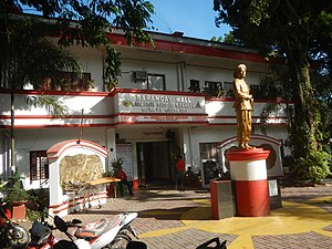
Rodriguez, Rizal
Municipality in Rizal, Philippines
Distance: Approx. 2659 meters
Latitude and longitude: 14.72,121.12
Rodriguez, officially the Municipality of Rodriguez (Tagalog: Bayan ng Rodriguez) and still commonly known by its former name Montalban, is a municipality in the province of Rizal, Philippines. According to the 2020 census, it has a population of 443,954 people making it the most populous municipality in the country. Pending an affirmation through plebiscite, Republic Act No.
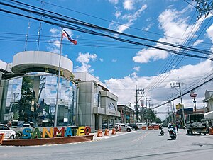
San Mateo, Rizal
Municipality in Rizal, Philippines
Distance: Approx. 4387 meters
Latitude and longitude: 14.69694,121.12194
San Mateo, officially the Municipality of San Mateo (Tagalog: Bayan ng San Mateo), is a municipality in the province of Rizal, Philippines. According to the 2020 census, it has a population of 273,306. Conurbated to the urban agglomeration of the Greater Manila Area, San Mateo is one of the fastest-growing municipalities in Rizal Province, according to the Metropolitan Manila Development Authority (MMDA) and the Provincial Government of Rizal.

Avilon Zoo
Zoo in Rizal, Philippines.
Distance: Approx. 1830 meters
Latitude and longitude: 14.74472222,121.15166667
Avilon Zoo is a 7.5-hectare (19-acre) zoo located in Barrio San Isidro, Rodriguez, Rizal, Philippines. It is operated by the Avilon Wildlife Conservation Foundation, which also operated the Ark Avilon Zoo in Pasig.
Bagong Silangan
Barangay in Quezon City, Metro Manila, Philippines
Distance: Approx. 5112 meters
Latitude and longitude: 14.70944444,121.1
Bagong Silangan is a barangay located in the 2nd district of Quezon City, Philippines. Nearby barangays are Commonwealth, Batasan Hills and Payatas. Separated by a river in the east, the barangay leads to the Municipality of San Mateo in the province of Rizal.

Colegio de Montalban
Public college in Rizal, Philippines
Distance: Approx. 2117 meters
Latitude and longitude: 14.75042,121.14166
Colegio de Montalban (CdM; formerly as the Pamantasan ng Montalban) is a government-funded university in Kasiglahan Village, Rodriguez, Rizal, Philippines. It was established on September 25, 2003 by virtue of Municipal Ordinance No. 03-24, and approved by the Sangguniang Bayan ng Rodriguez to provide vocational-technical and higher education to help alleviate poverty.
Payatas
Barangay in Quezon City, Metro Manila, Philippines
Distance: Approx. 5120 meters
Latitude and longitude: 14.70988889,121.09966667
Payatas is an administrative division in eastern Metro Manila, the Philippines. It is an urban barangay located in the 2nd district of Quezon City adjacent to the barangays of Commonwealth, Batasan Hills and Bagong Silangan.
San Mateo National High School
Public high school in Rizal, Philippines
Distance: Approx. 4653 meters
Latitude and longitude: 14.69469,121.12103
San Mateo National High School (SMNHS) is a government-funded secondary educational institution located in the Municipality of San Mateo, Rizal in the Philippines.

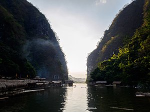
Wawa Dam
Dam in Rizal, Philippines
Distance: Approx. 5395 meters
Latitude and longitude: 14.72777778,121.19166667
Wawa Dam, also known as Montalban Dam, is a gravity dam constructed over the Marikina River in the municipality of Rodriguez, Rizal, Philippines. The slightly arched dam is situated in the 360-metre (1,180 ft) high Montalban Gorge or Wawa Gorge, a water gap in the Sierra Madre Mountains, east of Manila. Construction of the dam began in 1904, and it became operational in 1909, during the American colonial era, to provide the water needs for Manila.

Pamitinan Cave
Distance: Approx. 5209 meters
Latitude and longitude: 14.731821,121.19008383
Pamitinan Cave is a limestone cave in the foothills of the Sierra Madre mountain range near Wawa Dam in Rizal, the Philippines. It is located in the Pamitinan Protected Landscape, in the barangay of San Rafael, municipality of Rodriguez. The cave was formerly known as the '"Cave of Bernardo Carpio"'.

La Mesa Watershed Reservation
Protected area in Metro Manila, Philippines
Distance: Approx. 4605 meters
Latitude and longitude: 14.74361111,121.10083333
The La Mesa Watershed Reservation is a protected area that preserves the only major watershed in Metro Manila, Philippines. Also known as the Novaliches Watershed, it contains the last remaining rainforest of its size in Metro Manila surrounding the La Mesa Dam and Reservoir, the primary source of potable drinking water for 12 million residents in the Manila metropolitan area. The area is under jointly controlled and supervised by the Department of Environment and Natural Resources and the Metropolitan Waterworks and Sewerage System.
Pamitinan Protected Landscape
Protected area in Philippines
Distance: Approx. 4663 meters
Latitude and longitude: 14.73027778,121.185
The Pamitinan Protected Landscape is a Philippine protected area of approximately 608 hectares (1,500 acres) in the Sierra Madre mountain range, just 34 kilometres (21 mi) northeast of Manila. It contains and protects the Montalban Gorge formed by the Marikina River that separates Mount Pamitinan and Mount Binacayan in the municipality of Rodriguez in Rizal. Established in 1996 through Proclamation No.

Payatas dumpsite
Former open dumpsite in Quezon City, the Philippines
Distance: Approx. 4221 meters
Latitude and longitude: 14.71683333,121.1055
The Payatas dumpsite, also known as the Payatas Controlled Disposal Facility (PCDF), is a former garbage dump in the barangay of the same name in Quezon City, Metro Manila, the Philippines. Originally established in the 1970s, the former open dumpsite was home to scavengers who migrated to the area after the closure of the Smokey Mountain landfill in Tondo, Manila. After the Payatas landslide happened in 2000, the newly passed Ecological Solid Waste Management Act mandated the closure of open and controlled dumpsites.
Weather in this IP's area
overcast clouds
23 Celsius
24 Celsius
23 Celsius
23 Celsius
1012 hPa
90 %
1012 hPa
985 hPa
10000 meters
4.4 m/s
13.19 m/s
33 degree
99 %