203.130.10.216 - IP Lookup: Free IP Address Lookup, Postal Code Lookup, IP Location Lookup, IP ASN, Public IP
Country:
Region:
City:
Location:
Time Zone:
Postal Code:
IP information under different IP Channel
ip-api
Country
Region
City
ASN
Time Zone
ISP
Blacklist
Proxy
Latitude
Longitude
Postal
Route
Luminati
Country
ASN
Time Zone
Asia/Karachi
ISP
Supernet Limited Transit Autonomous System Number
Latitude
Longitude
Postal
IPinfo
Country
Region
City
ASN
Time Zone
ISP
Blacklist
Proxy
Latitude
Longitude
Postal
Route
IP2Location
203.130.10.216Country
Region
sindh
City
hyderabad
Time Zone
Asia/Karachi
ISP
Language
User-Agent
Latitude
Longitude
Postal
db-ip
Country
Region
City
ASN
Time Zone
ISP
Blacklist
Proxy
Latitude
Longitude
Postal
Route
ipdata
Country
Region
City
ASN
Time Zone
ISP
Blacklist
Proxy
Latitude
Longitude
Postal
Route
Popular places and events near this IP address
Firdous Colony
Residential neighbourhood within the city of Karachi, Pakistan
Distance: Approx. 1287 meters
Latitude and longitude: 25.4,68.38333333
Firdous Colony (Urdu: فردوس کالونی), officially Firdous Cooperative Housing Society, is a neighborhood in the Karachi Central district of Karachi, Pakistan. This society was formed by Mr. Shah Masood Ahmad, who came from Bihar-India and purchased this land for his people.

Saddar (Hyderabad)
Hyderabad neighbourhood
Distance: Approx. 980 meters
Latitude and longitude: 25.394,68.364
Saddar, literally meaning "cardinal", is the central area in the city of Hyderabad, Sindh, Pakistan. Saddar hosts the district and city's main governing bodies. It constitutes the centre of the city geographically and joins the suburbs at each end.

St Bonaventure's High School
Private primary and secondary school in Hyderabad, Sindh, Pakistan
Distance: Approx. 620 meters
Latitude and longitude: 25.393515,68.367534
St Bonaventure's High School (formerly St Bonaventure's Boys' High School) is a private Catholic primary and secondary school, located on Foujdari Road in Saddar, Hyderabad in the Sindh province of Pakistan. The school has another branch in the Hyderabad town of Qasimabad. The school is operated by the Roman Catholic diocese of Hyderabad.
St Mary's Convent High School, Hyderabad
Private primary and secondary school in Pakistan
Distance: Approx. 716 meters
Latitude and longitude: 25.393517,68.366565
St Mary's Convent High School (alternatively St Mary's Convent Girl's High School) is a private Catholic primary and secondary school for girls located on Foujdari Road in Hyderabad in the Sindh province of Pakistan. It was founded as a part of St Bonaventure's High School specifically aimed at the educational needs of girls in the city. The convent is run by resident nuns of the Catholic Diocese of Hyderabad.

Roman Catholic Diocese of Hyderabad in Pakistan
Roman Catholic diocese in Pakistan
Distance: Approx. 658 meters
Latitude and longitude: 25.3932,68.3671
The Roman Catholic Diocese of Hyderabad (Lat: Dioecesis Hyderabadensis in Pakistan) is a diocese of the Latin Church of the Roman Catholic Church in Pakistan.
Ilyasabad
Pakistani town
Distance: Approx. 364 meters
Latitude and longitude: 25.39538889,68.37530556
Ilyasabad (Urdu: الياس آباد) is a town in the southern suburbs of the city of Hyderabad, in Sindh, Pakistan.

Pacco Qillo
18 century fort Hyderabad, Sindh
Distance: Approx. 902 meters
Latitude and longitude: 25.38443889,68.37268611
Pakko Qillo (Sindhi: پڪو قلعو, Strong Fort) is a fort in Hyderabad, Sindh, Pakistan. It was built in the 18th century, and served as a strategic military base and played a crucial role in the city's history.

Hyderabad Junction railway station
Railway station in Sindh, Pakistan
Distance: Approx. 1269 meters
Latitude and longitude: 25.3811,68.37349892
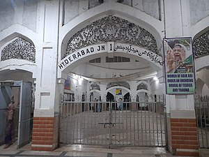
Hyderabad Junction Railway Station (Sindhi: حيدرآباد جنڪشن ريلوي اسٽيشن) is located in the city of Hyderabad, Sindh, Pakistan and serves as a major railway junction.
Civil Hospital, Hyderabad
Pakistani hospital
Distance: Approx. 1072 meters
Latitude and longitude: 25.4002,68.3672
The Civil Hospital, Hyderabad, also known as Liaquat University Hospital (LUH), is a 2200-bed tertiary care hospital in Hyderabad, Sindh. It is one of the largest teaching hospitals affiliated with Liaquat University of Medical and Health Sciences, Jamshoro, the first medical university of public sector in Pakistan. The hospital serves Sindh and the neighboring province of Balochistan.

Mukhi House
Museum in Hyderabad, Sindh, Pakistan
Distance: Approx. 756 meters
Latitude and longitude: 25.3862,68.3708
The Mukhi House, also known as Mukhi Mahal, is a museum located in Hyderabad, Sindh, Pakistan. For a brief period, it housed a government school named Khadija Girls School.

Hasrat Mohani Library
Public library in Hyderabad, Pakistan
Distance: Approx. 785 meters
Latitude and longitude: 25.385722,68.371441
Hasrat Mohani Library, also known as Hasrat Mohani District Central Library, Hyderabad, and formerly known as Holm Stead Free Readers Hall, (Urdu: حسرت موہانی لائبریری) is a public library located in Hyderabad, Sindh, Pakistan, adjacent to Pacco Qillo. It is the oldest library in the city of Hyderabad.

Navalrai Clock Tower, Hyderabad
Clock tower located in Hyderabad
Distance: Approx. 831 meters
Latitude and longitude: 25.39884,68.36924
Navalrai Clock Tower, Hyderabad, also known as Ghanta Ghar, Hyderabad, and Market Clock Tower, Hyderabad, (Urdu: نول رائے کلاک ٹاور) is a clock tower located in Hyderabad, Sindh.
Weather in this IP's area
clear sky
16 Celsius
14 Celsius
16 Celsius
16 Celsius
1018 hPa
18 %
1018 hPa
1014 hPa
10000 meters
1.97 m/s
2.02 m/s
79 degree