203.129.61.254 - IP Lookup: Free IP Address Lookup, Postal Code Lookup, IP Location Lookup, IP ASN, Public IP
Country:
Region:
City:
Location:
Time Zone:
Postal Code:
IP information under different IP Channel
ip-api
Country
Region
City
ASN
Time Zone
ISP
Blacklist
Proxy
Latitude
Longitude
Postal
Route
Luminati
Country
Region
vic
City
melbourne
ASN
Time Zone
Australia/Melbourne
ISP
TPG Telecom Limited
Latitude
Longitude
Postal
IPinfo
Country
Region
City
ASN
Time Zone
ISP
Blacklist
Proxy
Latitude
Longitude
Postal
Route
IP2Location
203.129.61.254Country
Region
victoria
City
clifton springs
Time Zone
Australia/Melbourne
ISP
Language
User-Agent
Latitude
Longitude
Postal
db-ip
Country
Region
City
ASN
Time Zone
ISP
Blacklist
Proxy
Latitude
Longitude
Postal
Route
ipdata
Country
Region
City
ASN
Time Zone
ISP
Blacklist
Proxy
Latitude
Longitude
Postal
Route
Popular places and events near this IP address

Clifton Springs, Victoria
Town in Victoria, Australia
Distance: Approx. 1258 meters
Latitude and longitude: -38.15,144.56666667
Clifton Springs is a coastal town located on the Bellarine Peninsula, near Geelong, Victoria, Australia.
Wallington, Victoria
Town in Victoria, Australia
Distance: Approx. 7917 meters
Latitude and longitude: -38.2,144.48333333
Wallington is a locality in the Rural City of Geelong. At the 2016 census, the town and surrounding area had a population of 1,353. The township was settled in the early 1870s, the Post Office opening on 22 February 1872.

Drysdale, Victoria
Suburb of Geelong, Victoria, Australia
Distance: Approx. 1502 meters
Latitude and longitude: -38.16666667,144.56666667
Drysdale is a rural township near Geelong, Victoria, Australia, located on the Bellarine Peninsula. The town has an approximate population of over 3,700. Drysdale forms part of an urban area, along with nearby Clifton Springs, that had an estimated population of 13,494 at June 2016.
Bellarine Peninsula
Peninsula in Victoria, Australia
Distance: Approx. 6629 meters
Latitude and longitude: -38.212,144.527
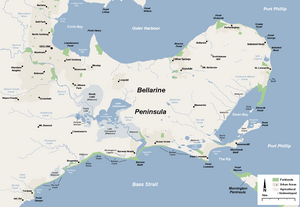
The Bellarine Peninsula (Wadawurrung: Balla-wein or Biteyong) is a peninsula located south-west of Melbourne in Victoria, Australia, surrounded by Port Phillip, Corio Bay and Bass Strait. The peninsula, together with the Mornington Peninsula, separates Port Phillip Bay from Bass Strait. The peninsula itself was originally occupied by Indigenous Australian clans of the Wadawurrung nation, prior to European settlement in the early 19th century.
Mannerim, Victoria
Town in Victoria, Australia
Distance: Approx. 7118 meters
Latitude and longitude: -38.21666667,144.58333333
Mannerim is a semi-rural locality on the Bellarine Peninsula of Victoria, Australia. Characterised by hobby farms and wineries, it is centred on the Grubb Road-Bellarine Highway intersection.

Drysdale railway station
Railway station in Victoria, Australia
Distance: Approx. 2600 meters
Latitude and longitude: -38.18,144.55722222
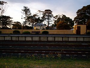
Drysdale is a railway station on the Queenscliff branch line off the main Warrnambool line in Victoria, Australia. It is 110 km (68 mi) from Melbourne, and 65 m (212 ft) above sea level. The station lies next to Lake Lorne and was first opened on 21 May 1879.
Saint Ignatius College, Geelong
Independent secondary day school in Drysdale, Victoria, Australia
Distance: Approx. 3617 meters
Latitude and longitude: -38.18916667,144.55666667
Saint Ignatius College is an independent Catholic secondary day school for boys and girls, located in the rural hinterland of the Bellarine Peninsula near Geelong, Victoria, Australia. The school provides education from Year 7 to Year 12, conducted in the Jesuit tradition, and operates with oversight from the Roman Catholic Archdiocese of Melbourne. The college is part of the international network of Jesuit schools begun in Messina, Sicily in 1548.
Adventure Park, Geelong
Amusement and water park in Wallington, Victoria, Australia
Distance: Approx. 6806 meters
Latitude and longitude: -38.209188,144.515212
Adventure Park is Victoria's biggest water theme park. The park offers many rides and attractions such as water slides, water playgrounds, action rides and family rides. The park was the first water park in Victoria, though has since also installed dry theme park attractions, such as a Crazy Coaster and a Ferris wheel.
Curlewis, Victoria
Suburb of Geelong, Victoria, Australia
Distance: Approx. 5661 meters
Latitude and longitude: -38.18333333,144.5
Curlewis is a locality in the City of Greater Geelong local government area on the Bellarine Peninsula, Victoria, Australia. At the 2021 census, Curlewis had a population of 4,175. Its surrounding suburbs are Drysdale, Leopold and Wallington, with waterfront access to Port Phillip Bay to the north.
Bellarine Secondary College
School in Victoria, Australia
Distance: Approx. 3789 meters
Latitude and longitude: -38.19072222,144.55644444
Bellarine Secondary College is a multi-campus school on the Bellarine Peninsula, Australia. The college consists of 2 campuses, one in Ocean Grove, and the main campus in Drysdale.

Lake Lorne
Lake in Victoria, Australia
Distance: Approx. 2822 meters
Latitude and longitude: -38.18194444,144.55805556
Lake Lorne, a small 12-hectare (30-acre) freshwater lake on the Bellarine Peninsula, Victoria, Australia, is located immediately south-west of the township of Drysdale.
Bellarine, Victoria
Suburb of Geelong, Victoria, Australia
Distance: Approx. 6280 meters
Latitude and longitude: -38.13222222,144.61972222
Bellarine is a locality in the City of Greater Geelong, Victoria, Australia. In the 2011 census, the population of Bellarine was too low to separately report; however in June 2014 the Victorian Electoral Commission recorded 134 enrolled voters in Bellarine, living in 81 properties.
Weather in this IP's area
broken clouds
14 Celsius
13 Celsius
10 Celsius
14 Celsius
1011 hPa
67 %
1011 hPa
1010 hPa
10000 meters
3.6 m/s
210 degree
75 %
