Country:
 New Zealand
Region:
City:
Latitude and Longitude:
Time Zone:
Postal Code:
IP information under different IP Channel
ip-api
Country
Region
City
ASN
Time Zone
ISP
Blacklist
Proxy
Latitude
Longitude
Postal
Route
IPinfo
Country
Region
City
ASN
Time Zone
ISP
Blacklist
Proxy
Latitude
Longitude
Postal
Route
MaxMind
Country
Region
City
ASN
Time Zone
ISP
Blacklist
Proxy
Latitude
Longitude
Postal
Route
Luminati
Country
NZRegion
mwt
City
palmerstonnorth
ASN
Time Zone
Pacific/Auckland
ISP
InSPire Net Ltd
Latitude
Longitude
Postal
db-ip
Country
Region
City
ASN
Time Zone
ISP
Blacklist
Proxy
Latitude
Longitude
Postal
Route
ipdata
Country
Region
City
ASN
Time Zone
ISP
Blacklist
Proxy
Latitude
Longitude
Postal
Route
Popular places and events near this IP address
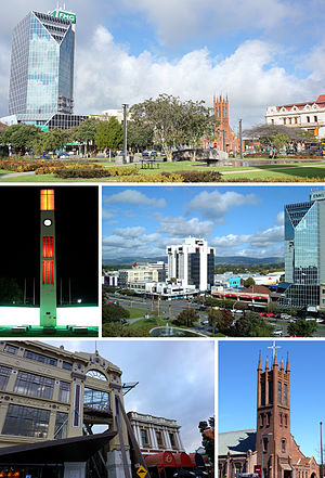
Palmerston North
City in North Island, New Zealand
Distance: Approx. 892 meters
Latitude and longitude: -40.355,175.61166667
Palmerston North (; Māori: Te Papa-i-Oea, known colloquially as Palmy) is a city in the North Island of New Zealand and the seat of the Manawatū-Whanganui region. Located in the eastern Manawatu Plains, the city is near the north bank of the Manawatu River, 35 km (22 mi) from the river's mouth, and 12 km (7 mi) from the end of the Manawatū Gorge, about 140 km (87 mi) north of the capital, Wellington. Palmerston North is the country's eighth-largest urban area, with an urban population of 82,500 (June 2023).

Universal College of Learning
Technical school in Palmerston North, New Zealand
Distance: Approx. 901 meters
Latitude and longitude: -40.35256,175.61271
The Universal College of Learning (UCOL) is a New Zealand Government ITP (Industry Training Provider/Polytechnic) with campuses located in Palmerston North, Whanganui, Masterton and Levin. Jasmine Groves is the institute's current Operational Lead.
Papaioea
Suburb of Palmerston North
Distance: Approx. 957 meters
Latitude and longitude: -40.3479,175.622
Papaioea is a suburb of Palmerston North on New Zealand's North Island. Its name comes from the name of the original settlement in a clearing in forest which was purchased from local Māori (Ngāti Rangitāne) in 1864. The name was used to describe Palmerston North also.

Palmerston North Central
Central business district of Palmerston North
Distance: Approx. 934 meters
Latitude and longitude: -40.356,175.611
Palmerston North Central is the central suburb and central business district of Palmerston North, on New Zealand's North Island. State Highway 3 passes through the area along Rangitikei Street, Main Street East, Grey Street and Princess Street.
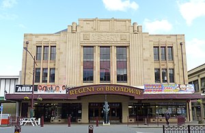
Regent on Broadway
Theatre in Palmerston North, New Zealand
Distance: Approx. 834 meters
Latitude and longitude: -40.35388889,175.61277778
The Regent on Broadway is a large theatre in Palmerston North, New Zealand, named so because it is the Regent Theatre on Broadway Avenue.
Swampfest
New Zealand annual musical festival
Distance: Approx. 892 meters
Latitude and longitude: -40.355,175.61166667
Swampfest is an annual musical festival that showcases Palmerston North bands. Swampfest was originally timed to coincide with New Zealand Music Month (May), but in 2009 switched to September to match the 21st birthday of The Stomach's, which is a music performing and rehearsal space in the city. Swampfest showcases local up-and-coming and established artists who play original music.
2XS FM
New Zealand radio station
Distance: Approx. 836 meters
Latitude and longitude: -40.355746,175.61219
2XS FM was a radio station in Palmerston North, New Zealand. 2XS started on 29 May 1981 at 8:28 in the morning, broadcasting on 828AM, the name was taken from the stations call sign 2XS. In 1986 2XS began broadcasting on 92.2FM with the call sign 2XXS and the station became known as 92.2XS FM. The 828AM frequency was later used by 2XS FM to start a second station Bright and Easy 828AM, this station was later known as Classic Hits 828 (no connection to Classic Hits FM network) before becoming Magic 828 & 98.6FM. The station has enjoyed a significant market share, anchored by local long-serving breakfast host Mike West, since the early 1990s. A string of personalities have worked on the station, including Stu Tolan (MORE FM network), Dom Harvey (under his pseudonym Baldrick; The Edge Breakfast), Mark Smith (Sound/Magic Network), Robert Scott (The Breeze Drive), Martin Good (Classic Hits Hawkes Bay Breakfast), Hamish McKay (Newshub sports presenter) and others.

The Plaza Shopping Centre
Shopping mall in Palmerston North, New Zealand
Distance: Approx. 763 meters
Latitude and longitude: -40.35696,175.613019
The Plaza Shopping Centre is a shopping mall in the central area of Palmerston North, New Zealand owned by Kiwi Property. It is the largest shopping mall in the Manawatu region.
Carncot Independent School for Girls and Boys
School
Distance: Approx. 750 meters
Latitude and longitude: -40.34977,175.621691
Carncot Independent School is a coeducational independent day school serving Years 1 to 8. It is located close to the center of the city of Palmerston North, in the Manawatū District, New Zealand. Europeans make up 70% of the roll, with Māori, Pacific Island, European, South African, Middle, and Far Eastern families represented.

Cathedral of the Holy Spirit, Palmerston North
Church in Palmerston North, New Zealand
Distance: Approx. 671 meters
Latitude and longitude: -40.35166,175.61728
The Cathedral of the Holy Spirit is the cathedral of the Roman Catholic Diocese of Palmerston North, New Zealand. It opened in 1925 as St Patrick's Church and was rededicated to the Holy Spirit as the cathedral when the diocese was established in 1980. In 1988, the cathedral was renovated, expanded and reordered.

2ZA
Radio station in Palmerston North
Distance: Approx. 608 meters
Latitude and longitude: -40.3518459,175.6182481
2ZA was a radio station in Palmerston North, New Zealand.

All Saints Church, Palmerston North
Church in Palmerston North, New Zealand
Distance: Approx. 970 meters
Latitude and longitude: -40.35819444,175.61077778
All Saints Church in Palmerston North, New Zealand, is an Anglican heritage-registered church designed by eminent architect Frederick de Jersey Clere. The church has been closed since 2013 over concerns about earthquake resistance but there are plans to strengthen the structure.
Weather in this IP's area
broken clouds
7 Celsius
7 Celsius
7 Celsius
7 Celsius
991 hPa
96 %
991 hPa
987 hPa
10000 meters
0.28 m/s
1.64 m/s
325 degree
63 %
06:15:34
18:08:47