Country:
 Japan
JapanRegion:
City:
Latitude and Longitude:
Time Zone:
Postal Code:
IP information under different IP Channel
ip-api
Country
Region
City
ASN
Time Zone
ISP
Blacklist
Proxy
Latitude
Longitude
Postal
Route
IPinfo
Country
Region
City
ASN
Time Zone
ISP
Blacklist
Proxy
Latitude
Longitude
Postal
Route
MaxMind
Country
Region
City
ASN
Time Zone
ISP
Blacklist
Proxy
Latitude
Longitude
Postal
Route
Luminati
Country
JPRegion
39
City
kochi
ASN
Time Zone
Asia/Tokyo
ISP
STNet, Incorporated
Latitude
Longitude
Postal
db-ip
Country
Region
City
ASN
Time Zone
ISP
Blacklist
Proxy
Latitude
Longitude
Postal
Route
ipdata
Country
Region
City
ASN
Time Zone
ISP
Blacklist
Proxy
Latitude
Longitude
Postal
Route
Popular places and events near this IP address
Ōhashidōri Station
Tram station in Kōchi, Kōchi Prefecture, Japan
Distance: Approx. 603 meters
Latitude and longitude: 33.5589,133.536389
Ōhashidōri Station (大橋通駅, Ōhashidōri-eki) is a tram station in Kōchi, Kōchi Prefecture, Japan.

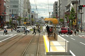
Kōchijō-mae Station
Tram station in Kōchi, Kōchi Prefecture, Japan
Distance: Approx. 464 meters
Latitude and longitude: 33.558438,133.534222
Kōchijō-mae Station (高知城前停留場, Kōchijō-mae-teiryujō) is a tram station in Kōchi, Kōchi Prefecture, Japan. It is operated by Tosaden Kōtsū.

Kenchō-mae Station (Kōchi)
Tram station in Kōchi, Kōchi Prefecture, Japan
Distance: Approx. 396 meters
Latitude and longitude: 33.558043,133.532236
Kenchō-mae Station (県庁前駅, Kenchō-mae-eki) is a tram station in Kōchi, Kōchi Prefecture, Japan.
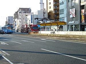
Gurando-dōri Station
Tram station in Kōchi, Kōchi Prefecture, Japan
Distance: Approx. 453 meters
Latitude and longitude: 33.557579,133.529389
Gurando-dōri Station (グランド通駅, Gurando-dōri-eki) is a tram station in Kōchi, Kōchi Prefecture, Japan.
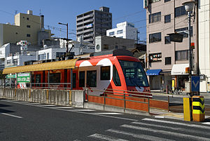
Masugata Station
Tram station in Kōchi, Kōchi Prefecture, Japan
Distance: Approx. 592 meters
Latitude and longitude: 33.557324,133.527181
Masugata Station (枡形駅, Masugata-eki) is a tram station in Kōchi, Kōchi Prefecture, Japan.

Kamimachi-itchōme Station
Tram station in Kōchi, Kōchi Prefecture, Japan
Distance: Approx. 764 meters
Latitude and longitude: 33.557312,133.525083
Kamimachi-itchōme Station (上町一丁目停留場, Kamimachi-itchōme-teiryujō) is a tram station in Kōchi, Kōchi Prefecture, Japan. It is operated by Tosaden Kōtsū.
Tosa Yamauchi Family Treasury and Archives
Distance: Approx. 163 meters
Latitude and longitude: 33.55544444,133.53125
The Tosa Yamauchi Family Treasury and Archives (土佐山内家宝物資料館, Tosa Yamauchi-ke Hōmotsu Shiryōkan) in Takajō-machi, Kōchi, Kōchi Prefecture, Japan, now permanently closed, formerly housed historical materials related to the Yamauchi clan, rulers of the Tosa Domain. Going back to an agreement between the Yamauchi family and Kōchi Prefecture from December 9, 1994, this foundation was formally established as a collaboration between Kōchi city and Kōchi Prefecture on April 26, 1995, with the aim of preserving and exhibiting the family's ancestral heritage of historical records, arts and crafts items. On May 1 of the same year the museum hall was opened.
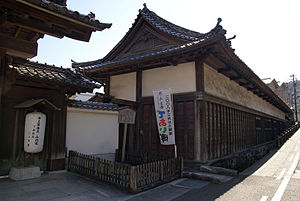
Former Yamauchi Residence
Distance: Approx. 181 meters
Latitude and longitude: 33.55555556,133.53111111
The Former Yamauchi Residence (旧山内家下屋敷長屋, Kyū Yamauchike shimoyashiki nagaya) in Kōchi, Kōchi Prefecture, Japan belonged to the Yamauchi daimyō of Tosa Domain. The nagaya of 1864, 33.4m x 5.7m, twin storey, with a hip-and-gable tiled roof, is an Important Cultural Property.
Kōchi, Kōchi
City in Japan
Distance: Approx. 501 meters
Latitude and longitude: 33.55888889,133.53138889
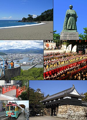
Kōchi (高知市, Kōchi-shi, pronounced [koːtɕi ꜜɕi]) is the capital city of Kōchi Prefecture located on the island of Shikoku in Japan. With over 40% of the prefectural population, Kōchi is the main commercial and industrial centre and the "primate city" of the prefecture. As of 1 April 2023, the city had an estimated population of 318,520 in 154,048 households, and a population density of 1,000 persons per km2.
Kōda River (Kōchi)
Distance: Approx. 544 meters
Latitude and longitude: 33.5531,133.526971
The Kōda (神田川, こうだがわ, kōdagawa) or Koda is a second class river in Kōchi City, Kōchi Prefecture It is a tributary on the right (south) side of the Kagami River (鏡川) The characters 神田川 can be read in many ways, including "Kanda River" (かんだがわ, kandagawa), and that is how the river is named on some English sources.
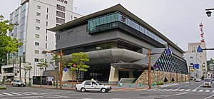
Kōchi Castle Museum of History
Building in Kōchi Prefecture, Japan
Distance: Approx. 650 meters
Latitude and longitude: 33.560213,133.53402
Kōchi Castle Museum of History (高知県立高知城歴史博物館, Kōchi Kenritsu Kōchi-jō Rekishi Hakubutsukan) opened in Kōchi, Kōchi Prefecture, Japan, in 2017. Located beside the main gate of Kōchi Castle, the collection tells the history of the Tosa Domain and of the Prefecture, and comprises the 67,000 items formerly preserved, researched, and exhibited at the Tosa Yamauchi Family Treasury and Archives.

Ryōma's Birthplace Memorial Museum
Museum in Kōchi, Japan
Distance: Approx. 782 meters
Latitude and longitude: 33.556491,133.524508
Ryōma's Birthplace Memorial Museum (高知市立龍馬の生まれたまち記念館, Kōchi Shiritsu Ryōma no Umareta Machi Kinenkan) opened in Kōchi, Kōchi Prefecture, Japan in 2004. It is dedicated to the life and times of Sakamoto Ryōma and to the local area of Kami-machi and Kōchi more generally during the Bakumatsu period.
Weather in this IP's area
overcast clouds
26 Celsius
26 Celsius
26 Celsius
26 Celsius
1017 hPa
89 %
1017 hPa
1016 hPa
10000 meters
0.75 m/s
1.18 m/s
342 degree
89 %
05:52:33
18:06:13