Country:
 Australia
Region:
City:
Latitude and Longitude:
Time Zone:
Postal Code:
IP information under different IP Channel
ip-api
Country
Region
City
ASN
Time Zone
ISP
Blacklist
Proxy
Latitude
Longitude
Postal
Route
IPinfo
Country
Region
City
ASN
Time Zone
ISP
Blacklist
Proxy
Latitude
Longitude
Postal
Route
MaxMind
Country
Region
City
ASN
Time Zone
ISP
Blacklist
Proxy
Latitude
Longitude
Postal
Route
Luminati
Country
AUASN
Time Zone
Australia/Sydney
ISP
Western Australian Land Information Authority
Latitude
Longitude
Postal
db-ip
Country
Region
City
ASN
Time Zone
ISP
Blacklist
Proxy
Latitude
Longitude
Postal
Route
ipdata
Country
Region
City
ASN
Time Zone
ISP
Blacklist
Proxy
Latitude
Longitude
Postal
Route
Popular places and events near this IP address
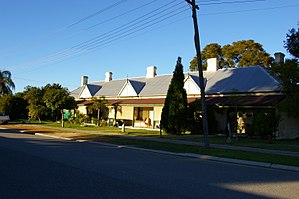
Bellevue, Western Australia
Suburb of Perth, Western Australia
Distance: Approx. 1623 meters
Latitude and longitude: -31.899,116.023
Bellevue is an eastern suburb of Perth, Western Australia in the local government areas of the City of Swan and the Shire of Mundaring. It is at the foot of the slopes of Greenmount, a landmark on the Darling Scarp that is noted in the earliest of travel journals of the early Swan River Colony.

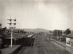
Midland railway station, Perth
Railway station in Perth, Western Australia
Distance: Approx. 1424 meters
Latitude and longitude: -31.891605,116.001399
Midland railway station is the terminus of the Midland line in Perth. Western Australia. It is operated by Transperth and is connected with the feeder bus services that utilise the adjacent bus terminal in Midland.

Midland Railway Workshops
Railway workshops in Midland, Western Australia
Distance: Approx. 1339 meters
Latitude and longitude: -31.8947,116.0051
The Midland Railway Workshops in Midland, Western Australia, were the main workshops for the Western Australian Government Railways (WAGR) for over 80 years.

Midvale, Western Australia
Suburb of Perth, Western Australia
Distance: Approx. 1061 meters
Latitude and longitude: -31.888,116.026
Midvale is a suburb of Perth, Western Australia, which is split between the City of Swan and the Shire of Mundaring. Its postcode is 6056. Developed in the early 1950s, the area was named as a composite of Midland and the former Helena Vale Racecourse.
Viveash, Western Australia
Suburb of Perth, Western Australia
Distance: Approx. 1876 meters
Latitude and longitude: -31.879,115.997
Viveash is an eastern suburb of Perth, Western Australia, in the City of Swan. It was named after Samuel Waterman Viveash, the owner of the land in this area in the 1840s. He came to the Swan River Colony on Britomart, which sailed from Spithead on 3 July 1838 and arrived at Fremantle on 5 December 1838, and took up land in the Avon Land District.
Midland Junction railway station
Former railway station in Perth, Western Australia
Distance: Approx. 1147 meters
Latitude and longitude: -31.8932,116.0062
The Midland Junction railway station was an important junction station on the Eastern Railway of Western Australia until its closure in 1966. Its history started on 1 March 1886 when Frederick Broome, then Governor of Western Australia, turned the first sod. It was the first railway station in Midland Junction and was replaced by the Midland station 300 metres (980 ft) west, across the tracks from the Midland Railway Workshops.

Bellevue railway station, Perth
Former railway station in Perth, Western Australia
Distance: Approx. 1867 meters
Latitude and longitude: -31.8988,116.0279
Bellevue railway station (also known as Bellevue Junction) was a junction station on the Eastern Railway in the Perth suburb of Bellevue.
Midland Gate
Shopping mall in Western Australia
Distance: Approx. 595 meters
Latitude and longitude: -31.889612,116.010261
Midland Gate is a shopping centre located in Midland, Western Australia. It is north of Great Eastern Highway, and east of the earlier Midland Junction shopping area that was focused on the Great Northern Highway. Midland Gate is one of three shopping centres in Western Australia with all three discount department stores – Kmart, Target and Big W, with the other two being Mandurah Forum and Lakeside Joondalup.
Swan District Hospital
Former hospital in Perth, Western Australia
Distance: Approx. 827 meters
Latitude and longitude: -31.88,116.01
The former Swan District Hospital was a general public hospital in Middle Swan, in Perth's north-eastern suburbs. The hospital had an emergency department, 193 beds, and also provided outpatient services. It closed on 24 November 2015 following the opening of the Midland Health Campus.

St John of God Midland Public and Private Hospitals
Hospital in Perth, Western Australia
Distance: Approx. 1113 meters
Latitude and longitude: -31.8948,116.0092
St John of God Midland Public and Private Hospitals is a health care facility in Midland, Western Australia which opened in November 2015. St John of God Health Care built and operates the hospitals under a public-private partnership with the Western Australian state government. St John of God Midland Public Hospital has replaced the nearby Swan District Hospital.

Midland, Western Australia
Suburb of Perth, Western Australia
Distance: Approx. 518 meters
Latitude and longitude: -31.888,116.01
Midland is a suburb and historic town of Perth, Western Australia, located 15 km (9.3 mi) northeast of Perth's central business district. It is the administrative seat and commercial centre of the City of Swan local government area. It is also a designated strategic metropolitan centre for the larger Perth metropolitan area.

La Salle College, Perth
School in Perth, Western Australia
Distance: Approx. 1261 meters
Latitude and longitude: -31.879,116.0046
La Salle College is a Roman Catholic co-educational secondary school in Middle Swan, Western Australia, an eastern suburb of Perth. It caters for approximately 1400 Year 7–12 students, including about 40 Aboriginal boarding students from regional and remote Western Australia.
Weather in this IP's area
clear sky
16 Celsius
15 Celsius
15 Celsius
17 Celsius
1025 hPa
52 %
1025 hPa
1023 hPa
10000 meters
5.66 m/s
160 degree
05:43:21
18:22:46