203.11.114.250 - IP Lookup: Free IP Address Lookup, Postal Code Lookup, IP Location Lookup, IP ASN, Public IP
Country:
Region:
City:
Location:
Time Zone:
Postal Code:
IP information under different IP Channel
ip-api
Country
Region
City
ASN
Time Zone
ISP
Blacklist
Proxy
Latitude
Longitude
Postal
Route
Luminati
Country
Region
eng
City
london
ASN
Time Zone
Europe/London
ISP
Jump Networks Ltd
Latitude
Longitude
Postal
IPinfo
Country
Region
City
ASN
Time Zone
ISP
Blacklist
Proxy
Latitude
Longitude
Postal
Route
IP2Location
203.11.114.250Country
Region
tasmania
City
george town
Time Zone
Australia/Hobart
ISP
Language
User-Agent
Latitude
Longitude
Postal
db-ip
Country
Region
City
ASN
Time Zone
ISP
Blacklist
Proxy
Latitude
Longitude
Postal
Route
ipdata
Country
Region
City
ASN
Time Zone
ISP
Blacklist
Proxy
Latitude
Longitude
Postal
Route
Popular places and events near this IP address

George Town, Tasmania
Town in Tasmania, Australia
Distance: Approx. 1007 meters
Latitude and longitude: -41.1,146.81666667
George Town (palawa kani: kinimathatakinta) is a large town in north-east Tasmania, on the eastern bank of the mouth of the Tamar River. The Australian Bureau of Statistics records the George Town Municipal Area had a population of 6,764 as of 30 June 2016. It is the regional centre of the George Town Council local government area and is well served with a Regional Hospital, supermarkets, and infrastructure.
Low Head
Town in Tasmania, Australia
Distance: Approx. 4856 meters
Latitude and longitude: -41.06666667,146.8
Low Head is a rural residential locality in the local government area (LGA) of George Town in the Launceston LGA region of Tasmania. The locality is about 5 kilometres (3.1 mi) north of the town of George Town. The 2016 census recorded a population of 572 for the state suburb of Low Head.
Bell Bay aluminium smelter
Distance: Approx. 4126 meters
Latitude and longitude: -41.12388889,146.86888889
The Bell Bay aluminium smelter is located on the Tamar River at Bell Bay, Tasmania, Australia. The smelter has a production capacity of 178,000 tonnes of aluminium per year. It is owned and operated by Pacific Aluminium, a wholly owned subsidiary of Rio Tinto Alcan.
Bell Bay, Tasmania
Port
Distance: Approx. 3619 meters
Latitude and longitude: -41.11666667,146.86666667
Bell Bay is an industrial centre and port located on the eastern shore of the Tamar River, in northern Tasmania, Australia. It lies just south of George Town. In the year ended June 2021, 3.6 million tonnes of exports and imports passed through Bell Bay.
Star of the Sea College, George Town
School in Australia
Distance: Approx. 395 meters
Latitude and longitude: -41.10819444,146.82930556
Star of the Sea College is a Catholic School in George Town, Tasmania founded by the Presentation Sisters in 1957.
Kelso, Tasmania
Town in Tasmania, Australia
Distance: Approx. 3587 meters
Latitude and longitude: -41.10555556,146.78333333
Kelso is a rural locality in the local government area (LGA) of West Tamar in the Launceston LGA region of Tasmania. The locality is about 14 kilometres (8.7 mi) north of the town of Beaconsfield. The 2016 census has a population of 146 for the state suburb of Kelso.
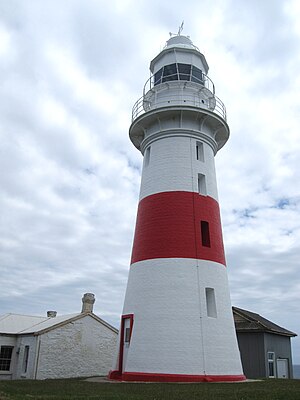
Low Head Lighthouse
Lighthouse in Tasmania, Australia
Distance: Approx. 6870 meters
Latitude and longitude: -41.05041667,146.78944444
Low Head Lighthouse is in Low Head, Tasmania, about 7 kilometres (4.3 mi) north of George Town on the east side of the mouth of the Tamar River. It was the third lighthouse to be constructed in Australia, and it is also Australia's oldest continuously used pilot station. This light is now unmanned and automated.
George Town Aerodrome
Airport in Tasmania, Australia
Distance: Approx. 3079 meters
Latitude and longitude: -41.08,146.84
George Town Aerodrome (IATA: GEE, ICAO: YGTO), also known as George Town Airport, is a minor airport serving George Town, Tasmania, Australia which is operated by George Town Airport Association.
Garden Island (Tamar River)
Tied island
Distance: Approx. 1406 meters
Latitude and longitude: -41.114573,146.814311
Garden Island is a tied island 2 kilometres (1.2 mi) from Clarence Point, near the mouth of the Tamar River in Tasmania. It is accessed by a dirt road off Bevic Road, which runs between West Tamar Highway, Kelso and Clarence Point Road. This large area is owned by TasPorts.
Clarence Point
Town in Tasmania, Australia
Distance: Approx. 3094 meters
Latitude and longitude: -41.12972222,146.80777778
Clarence Point is a locality in northern Tasmania about 3 kilometres (2 mi) southwest of George Town across the Tamar River. Most of its population is settled along the riverbank. Clarence Point is also the name of the regional area that includes the village, which is part of the West Tamar Municipal Area.

British and Tasmanian Charcoal Iron Company
Iron mining and smelting company
Distance: Approx. 4642 meters
Latitude and longitude: -41.14530556,146.80916667
The British and Tasmanian Charcoal Iron Company (BTCIC) was an iron mining and smelting company that operated from 1874 to 1878 in Northern Tasmania, Australia. It was formed by floating the operations of a private company, the Tasmanian Charcoal Iron Company that operated between 1871 and 1874. This venture was the largest of the four that smelted iron from local iron ore in Tasmania during the 1870s.
Notley Hills, Tasmania
Town in Tasmania, Australia
Distance: Approx. 3981 meters
Latitude and longitude: -41.1262,146.7873
Notley Hills is a rural locality in the local government area of West Tamar in the Launceston region of Tasmania. It is located about 24 kilometres (15 mi) north-west of the town of Launceston. The 2016 census determined a population of 46 for the state suburb of Notley Hills.
Weather in this IP's area
few clouds
16 Celsius
15 Celsius
16 Celsius
16 Celsius
1021 hPa
49 %
1021 hPa
1011 hPa
10000 meters
1.29 m/s
1.34 m/s
280 degree
19 %

