203.1.110.179 - IP Lookup: Free IP Address Lookup, Postal Code Lookup, IP Location Lookup, IP ASN, Public IP
Country:
Region:
City:
Location:
Time Zone:
Postal Code:
IP information under different IP Channel
ip-api
Country
Region
City
ASN
Time Zone
ISP
Blacklist
Proxy
Latitude
Longitude
Postal
Route
Luminati
Country
ASN
Time Zone
Australia/Sydney
ISP
Australian Academic and Research Network AARNet
Latitude
Longitude
Postal
IPinfo
Country
Region
City
ASN
Time Zone
ISP
Blacklist
Proxy
Latitude
Longitude
Postal
Route
IP2Location
203.1.110.179Country
Region
victoria
City
epping
Time Zone
Australia/Melbourne
ISP
Language
User-Agent
Latitude
Longitude
Postal
db-ip
Country
Region
City
ASN
Time Zone
ISP
Blacklist
Proxy
Latitude
Longitude
Postal
Route
ipdata
Country
Region
City
ASN
Time Zone
ISP
Blacklist
Proxy
Latitude
Longitude
Postal
Route
Popular places and events near this IP address

Epping, Victoria
Suburb of Melbourne, Victoria, Australia
Distance: Approx. 1491 meters
Latitude and longitude: -37.63777778,145.02638889
Epping is a suburb in Melbourne, Victoria, Australia, 18 km (11 mi) north of Melbourne's central business district, located within the City of Whittlesea local government area. Epping recorded a population of 33,489 at the 2021 census.

Lalor, Victoria
Suburb of Melbourne, Victoria, Australia
Distance: Approx. 2226 meters
Latitude and longitude: -37.667,145.02
Lalor () is a suburb in Melbourne, Victoria, Australia, 17 km (11 mi) north of Melbourne's Central Business District, located within the City of Whittlesea local government area. Lalor recorded a population of 23,219 at the 2021 census. Lalor was named in honour of Peter Lalor, a leader of the Eureka Stockade rebellion and later a member of the Victorian parliament.

Lalor railway station
Railway station in Melbourne, Australia
Distance: Approx. 2263 meters
Latitude and longitude: -37.6659,145.0173
Lalor railway station is a commuter railway station on the Mernda line, which is part of the Melbourne railway network. It serves the northern suburb of Lalor, in Melbourne, Victoria, Australia. Lalor is a ground-level staffed station, featuring an island platform with two faces.

Epping railway station, Melbourne
Railway station in Melbourne, Australia
Distance: Approx. 321 meters
Latitude and longitude: -37.6521,145.0308
Epping railway station is a commuter railway station on the Mernda line, which is part of the Melbourne railway network, and serves the northern suburb of the same name in Melbourne, Victoria, Australia. It opened on 23 December 1889 and, since 2011, it has been a below-ground, premium station, with an island platform.

Division of Scullin
Australian federal electoral division
Distance: Approx. 2260 meters
Latitude and longitude: -37.663,145.053
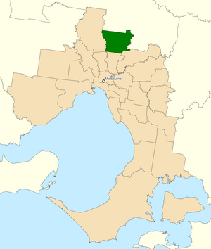
The Division of Scullin is an Australian Electoral Division in the state of Victoria. It is located in the outer northern suburbs of Melbourne, including Epping, Lalor, Mill Park, South Morang, Thomastown, Wollert and Bundoora.
St Monica's College
Catholic secondary school in Melbourne, Victoria, Australia
Distance: Approx. 294 meters
Latitude and longitude: -37.65111111,145.03027778
St Monica's College is a Catholic co-educational secondary school which was established in 1964. Located across two main campuses, it is situated just north of Melbourne, Australia in the suburb of Epping. The College also includes a small country campus in Strath Creek which is used as a retreat and by visiting class groups.
Pacific Epping
Shopping mall in Victoria, Australia
Distance: Approx. 928 meters
Latitude and longitude: -37.652004,145.023085
Pacific Epping is a shopping centre in Epping, Victoria, a suburb of Melbourne, Australia. It opened in 1996. It is located on the corner of High Street and Cooper Street, 500 m (1,600 ft) away from Epping railway station, Melbourne, and approximately 20 km (12 mi) north of the Melbourne CBD. Until September 2013, the shopping centre was known as Epping Plaza.
Mill Park Secondary College
Public state-run high school in Victoria, Australia
Distance: Approx. 2639 meters
Latitude and longitude: -37.64583333,145.06277778
Mill Park Secondary College is a government high school located in Epping, Victoria, Australia with its Junior Campus located on Moorhead Drive Mill Park and its Senior Campus located on Civic Drive. The high school was built in the early 1990s for the residents of Mill Park, however due to population growth, a Senior campus was established around 1997 for students entering the years of 10, 11 and 12. In the current day, Mill Park Secondary College has approximately 1,820 students.
Epping Stadium
Distance: Approx. 2884 meters
Latitude and longitude: -37.625,145.02472222
Epping Stadium is an Australian soccer ground on Harvest Home Rd in Epping, a suburb of Melbourne, Victoria. Opened in 1999 the stadium has a capacity of 10,000, with approximately 1000 seats in its sole grandstand. The venue was host to several National Soccer League matches during the final days of Carlton SC, and has also hosted A-League clubs Melbourne Heart and Melbourne Victory in pre-season matches, as well as W-League Matches and National Youth League matches.

The Northern Hospital, Epping
Hospital in Victoria, Australia
Distance: Approx. 1727 meters
Latitude and longitude: -37.65333333,145.01416667
The Northern Hospital (TNH) in Epping, Melbourne, Australia, is major community hospital. It lies in the north of Melbourne, next to Pacific Epping. It is a 400-bed hospital serving the northern suburbs of Melbourne, as well as the surrounding country areas of Victoria.
Epping Secondary College
School in Epping, Victoria, Australia
Distance: Approx. 588 meters
Latitude and longitude: -37.64472222,145.03333333
Epping Secondary College is a secondary school located in Epping, Victoria, Australia. Education is provided for years 7–12 on one campus and offers VCE, VCAL and VET courses in years 11 and 12. The current principal is Dion Velluto.

St. George & St. Mary Mother of God Macedonian Orthodox Church, Epping
Church in Victoria, Australia
Distance: Approx. 1389 meters
Latitude and longitude: -37.65762,145.02082
St. George & St. Mary Mother of God Macedonian Orthodox Church (Macedonian: Македонска Православна Црква „Св.
Weather in this IP's area
scattered clouds
16 Celsius
15 Celsius
14 Celsius
16 Celsius
1011 hPa
66 %
1011 hPa
995 hPa
10000 meters
3.6 m/s
10 degree
44 %