Country:
Region:
City:
Latitude and Longitude:
Time Zone:
Postal Code:
IP information under different IP Channel
ip-api
Country
Region
City
ASN
Time Zone
ISP
Blacklist
Proxy
Latitude
Longitude
Postal
Route
Luminati
Country
City
singapore
ASN
Time Zone
Asia/Singapore
ISP
DE-CORP
Latitude
Longitude
Postal
IPinfo
Country
Region
City
ASN
Time Zone
ISP
Blacklist
Proxy
Latitude
Longitude
Postal
Route
db-ip
Country
Region
City
ASN
Time Zone
ISP
Blacklist
Proxy
Latitude
Longitude
Postal
Route
ipdata
Country
Region
City
ASN
Time Zone
ISP
Blacklist
Proxy
Latitude
Longitude
Postal
Route
Popular places and events near this IP address

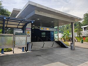
HarbourFront MRT station
Mass Rapid Transit station in Singapore
Distance: Approx. 199 meters
Latitude and longitude: 1.26527778,103.82222222
HarbourFront MRT station is an underground Mass Rapid Transit (MRT) interchange station in Singapore. The termini of the North East line (NEL) and Circle line (CCL), the station serves the HarbourFront area and Sentosa. Surrounding retail and commercial developments include VivoCity and HarbourFront Centre, and the station is near HarbourFront Bus Interchange and the Singapore Cruise Centre.

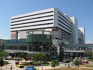
VivoCity
Shopping mall in HarbourFront Walk, Singapore
Distance: Approx. 266 meters
Latitude and longitude: 1.26388889,103.82222222
VivoCity is a shopping mall located in the HarbourFront precinct of Bukit Merah, Singapore. It is the largest shopping mall in Singapore, with 99,987 square metres (1,076,250 square feet) of net lettable area and 142,854 square metres (1,537,670 square feet) of gross floor area spread over a three-storey shopping complex and two basement levels. It was designed by the Japanese architect Toyo Ito, and its name is derived from the word vivacity.
Radin Mas, Singapore
Place
Distance: Approx. 559 meters
Latitude and longitude: 1.2693,103.82727
Radin Mas is a neighbourhood within Telok Blangah Estate, located in Bukit Merah, Singapore.
HarbourFront Centre
Singapore shopping mall and ferry terminal
Distance: Approx. 460 meters
Latitude and longitude: 1.26444444,103.82
HarbourFront Centre, formerly World Trade Centre, is a shopping mall and ferry terminal in Singapore. The mall is part of a development known as HarbourFront.

Masjid Temenggong Daeng Ibrahim
Distance: Approx. 102 meters
Latitude and longitude: 1.2663521,103.8242979
Masjid Temenggong Daeng Ibrahim (Jawi: مسجد تماڠڬوڠ دايڠ إبراهيم), also known as Masjid Diraja Telok Blangah (Malay: Telok Blangah Royal Mosque), is a historical royal mosque that is located along 30 Telok Blangah Road in Telok Blangah within Bukit Merah, Singapore. The mosque dates back to the country’s pre-colonial era when Singapore was part of the Sultanate of Johor, serving as a royal residence, and eventually converted into a royal mosque with a royal burial ground for the Johor monarchy. Within the grounds of the mosque, the Johor Royal Mausoleum of Telok Blangah and Tanah Kubor Temenggong Johor (Malay: The Temenggong of Johor Cemetery) are co-located altogether which are all owned by the State of Johor and the Sultan of Johor.
Makam Diraja Johor Telok Blangah
Cemetery in Singapore
Distance: Approx. 125 meters
Latitude and longitude: 1.26638889,103.82466667
Makam Diraja Johor Telok Blangah (Jawi: مقام دراج خوهر تاوق بلاڠه) is a Johor royal mausoleum co-located next to the grounds of Masjid Temenggong Daeng Ibrahim in Telok Blangah, Singapore. The royal cemetery is the final resting place of the descendants of the House of Temenggong from 1825 to 1900.
Singapore Cruise Centre
Cruise terminal in Singapore
Distance: Approx. 464 meters
Latitude and longitude: 1.26361111,103.82027778
The Singapore Cruise Centre (abbrev: SCC; Chinese: 新加坡邮轮中心) is a cruise terminal located in the south of Singapore next to HarbourFront Centre in the vicinity of HarbourFront and in Keppel Harbour, near HarbourFront MRT station.

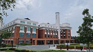
St James Power Station
Building in Sentosa Gateway, Singapore
Distance: Approx. 117 meters
Latitude and longitude: 1.2647,103.8247
St James Power Station is a building located in HarbourFront, Singapore. Built in 1926, it was Singapore's first power station, having supplied electricity to the nearby port and the surrounding industries, shipyards and residences. It was previously also the one and only coal-fired power plant in the country.

The Maritime Experiential Museum
Maritime museum in Sentosa Gateway, Singapore
Distance: Approx. 887 meters
Latitude and longitude: 1.25833333,103.8205
The Maritime Experiential Museum (Simplified Chinese: 海事博物馆及水族馆 (Maritime Museum and Aquarium)), formerly the Maritime Xperiential Museum and the Maritime Experiential Museum & Aquarium, was a museum in Resorts World Sentosa, Sentosa, Singapore, built to house the Jewel of Muscat. It was opened on 15 October 2011 and was closed on 2 March 2020 to become part of the new Singapore Oceanarium, an expansion of the former S.E.A. Aquarium.

Library@harbourfront
Public library in Singapore
Distance: Approx. 266 meters
Latitude and longitude: 1.26388889,103.82222222
library@harbourfront, formerly known as Bukit Merah Public Library, is a public library located at VivoCity, Singapore. It is the largest shopping mall public library in Singapore.

Istana Lama
Distance: Approx. 178 meters
Latitude and longitude: 1.26666667,103.82291667
The Istana Lama was a palace once located at Telok Blangah in Singapore. It was first built for Temenggong Abdul Rahman in 1824. It had since been demolished in 1954.
Prima Tower Revolving Restaurant
Restaurant
Distance: Approx. 223 meters
Latitude and longitude: 1.26538889,103.826
Prima Tower Revolving Restaurant was a Chinese restaurant in Singapore owned and managed by Prima Tower Pte Ltd. The restaurant opened in 1977, and was touted for being the "world’s only revolving restaurant nestled on a grain silo". It served Beijing cuisine and offered views of Sentosa, Mount Faber and the Cable Car.
Weather in this IP's area
light rain
26 Celsius
26 Celsius
25 Celsius
26 Celsius
1010 hPa
91 %
1010 hPa
1008 hPa
10000 meters
1.54 m/s
340 degree
75 %
06:48:32
18:51:59


