Country:
 Australia
Region:
City:
Latitude and Longitude:
Time Zone:
Postal Code:
IP information under different IP Channel
ip-api
Country
Region
City
ASN
Time Zone
ISP
Blacklist
Proxy
Latitude
Longitude
Postal
Route
IPinfo
Country
Region
City
ASN
Time Zone
ISP
Blacklist
Proxy
Latitude
Longitude
Postal
Route
MaxMind
Country
Region
City
ASN
Time Zone
ISP
Blacklist
Proxy
Latitude
Longitude
Postal
Route
Luminati
Country
AURegion
qld
City
brisbane
ASN
Time Zone
Australia/Brisbane
ISP
Over The Wire Pty Ltd
Latitude
Longitude
Postal
db-ip
Country
Region
City
ASN
Time Zone
ISP
Blacklist
Proxy
Latitude
Longitude
Postal
Route
ipdata
Country
Region
City
ASN
Time Zone
ISP
Blacklist
Proxy
Latitude
Longitude
Postal
Route
Popular places and events near this IP address
Stafford, Queensland
Suburb of Brisbane, Queensland, Australia
Distance: Approx. 1427 meters
Latitude and longitude: -27.4122,153.0102
Stafford is a northern suburb in the City of Brisbane, Queensland, Australia. In the 2021 census, Stafford had a population of 6,978 people.

Grange, Queensland
Suburb of Brisbane, Queensland, Australia
Distance: Approx. 478 meters
Latitude and longitude: -27.4233,153.0144
Grange is a northern suburb in the City of Brisbane, Queensland, Australia. In the 2021 census, Grange had a population of 4,615 people.
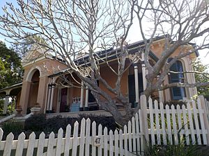
Farrington House, Alderley
Historic site in Queensland, Australia
Distance: Approx. 1315 meters
Latitude and longitude: -27.4227,153.0058
Farrington House is a heritage-listed detached house at 39 David Street, Alderley, Queensland, Australia. It was built c. 1882. It is also known as Clifford House.

Newmarket Brickworks Chimney
Historic site in Queensland, Australia
Distance: Approx. 1391 meters
Latitude and longitude: -27.4277,153.0064
Newmarket Brickworks Chimney is a heritage-listed brickworks at 117 Mina Parade, Alderley, City of Brisbane, Queensland, Australia. It was built in 1912. It is also known as Hoffman Stack.
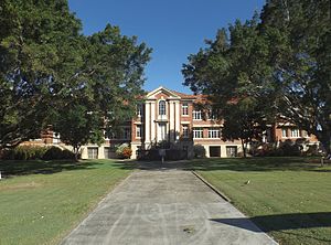
Stafford State School
Historic site in Queensland, Australia
Distance: Approx. 1165 meters
Latitude and longitude: -27.4119,153.0178
Stafford State School is a heritage-listed state school at 314 Stafford Road, Stafford, City of Brisbane, Queensland, Australia. It was designed by the Queensland Department of Public Works and built from 1948 to 1955. It was added to the Queensland Heritage Register on 26 February 1999.

Windsor Air Raid Shelter
Historic site in Queensland, Australia
Distance: Approx. 1433 meters
Latitude and longitude: -27.4253,153.0332
Windsor Air Raid Shelter is a heritage-listed former air raid shelter at Lutwyche Road, Lutwyche, City of Brisbane, Queensland, Australia. It was designed by Frank Gibson Costello and built c. 1942 by Brisbane City Council. It was added to the Queensland Heritage Register on 6 April 2005.

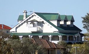
Kirkston
Historic site in Queensland, Australia
Distance: Approx. 1299 meters
Latitude and longitude: -27.4278,153.0307
Kirkston is a heritage-listed villa at 23 Rupert Street, Windsor, City of Brisbane, Queensland, Australia. It was designed by George Henry Male Addison and built from 1888 to 1889 by John William Young. It was added to the Queensland Heritage Register on 21 October 1992.
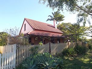
The Grange, Windsor
Historic site in Queensland, Australia
Distance: Approx. 786 meters
Latitude and longitude: -27.4249,153.0265
The Grange is a heritage-listed detached house at 38 Crowther Street, Windsor, City of Brisbane, Queensland, Australia. It was built from c. 1874 to 1877. It was added to the Queensland Heritage Register on 21 October 1992.

Bess Street Brick Cottages
Historic site in Queensland, Australia
Distance: Approx. 1121 meters
Latitude and longitude: -27.4259,153.0297
Bess Street Brick Cottages is a heritage-listed duplex at 22, 25-27 Bess Street, Windsor, City of Brisbane, Queensland, Australia. It was built from c. 1880 to 1930s circa. It is also known as Hedge's Buildings.
Wilston House
Historic site in Queensland, Australia
Distance: Approx. 1311 meters
Latitude and longitude: -27.4328,153.0131
Wilston House is a heritage-listed villa at 47 Watson Street, Newmarket, City of Brisbane, Queensland, Australia. It was designed by architect James Cowlishaw and built from c. 1876 to c. 1880. It was added to the Queensland Heritage Register on 21 October 1992.
Wilston State School
Historic site in Queensland, Australia
Distance: Approx. 737 meters
Latitude and longitude: -27.428,153.0153
Wilston State School is a heritage-listed state school at Primrose Street, Grange, City of Brisbane, Queensland, Australia. It was built from 1920. Architects who designed the school's buildings include Arthur Gordon Femister Greenway and Blackburne and Gzell.

Wilston Methodist Memorial Church
Historic site in Queensland, Australia
Distance: Approx. 690 meters
Latitude and longitude: -27.4285,153.0189
Wilston Methodist Memorial Church is a heritage-listed former church at 181 Kedron Brook Road, Wilston, Queensland, Australia. It was designed by Ford, Hutton & Newell and built in 1956. It is also known as Trinity Grove Uniting Church, Trinity-Wilston Memorial Uniting Church, Wilston Uniting Church, and Wilston Methodist Church.
Weather in this IP's area
clear sky
28 Celsius
27 Celsius
27 Celsius
30 Celsius
1011 hPa
36 %
1011 hPa
1009 hPa
10000 meters
4.12 m/s
30 degree
05:39:59
17:42:56