Country:
 Luxembourg
Region:
City:
Latitude and Longitude:
Time Zone:
Postal Code:
IP information under different IP Channel
ip-api
Country
Region
City
ASN
Time Zone
ISP
Blacklist
Proxy
Latitude
Longitude
Postal
Route
IPinfo
Country
Region
City
ASN
Time Zone
ISP
Blacklist
Proxy
Latitude
Longitude
Postal
Route
MaxMind
Country
Region
City
ASN
Time Zone
ISP
Blacklist
Proxy
Latitude
Longitude
Postal
Route
Luminati
Country
LUASN
Time Zone
Europe/Luxembourg
ISP
G-Core Labs S.A.
Latitude
Longitude
Postal
db-ip
Country
Region
City
ASN
Time Zone
ISP
Blacklist
Proxy
Latitude
Longitude
Postal
Route
ipdata
Country
Region
City
ASN
Time Zone
ISP
Blacklist
Proxy
Latitude
Longitude
Postal
Route
Popular places and events near this IP address
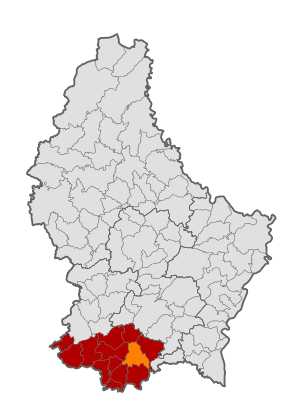
Bettembourg
Commune in Esch-sur-Alzette, Luxembourg
Distance: Approx. 974 meters
Latitude and longitude: 49.5167,6.1
Bettembourg (French pronunciation: [bɛtɑ̃buʁ]; Luxembourgish: Beetebuerg, pronounced [ˈbeːtəbuːɐ̯ɕ] ; German: Bettemburg, pronounced [ˈbɛtmˌbʊrk]) is a commune and town in southern Luxembourg. The country's eighth-most populous commune, it is part of the canton of Esch-sur-Alzette. As of 2024, the town of Bettembourg, which lies in the east of the commune, has a population of 9,160.

Fennange
Town in the commune of Bettembourg in Luxembourg
Distance: Approx. 2054 meters
Latitude and longitude: 49.51666667,6.08333333
Fennange (Luxembourgish: Fënnéng, German: Fenningen) is a small town in the commune of Bettembourg, in southern Luxembourg. As of 2024, the town has a population of 418. A notable resident was the sculptor Maggy Stein.
Hellange
Town
Distance: Approx. 3117 meters
Latitude and longitude: 49.5,6.15
Hellange (Luxembourgish: Helléng, German: Hellingen) is a small town in the commune of Frisange, in southern Luxembourg. As of 2024, the town has a population of 875.
Berchem, Luxembourg
Town in the commune of Roeser in Luxembourg
Distance: Approx. 2966 meters
Latitude and longitude: 49.53333333,6.13333333
Berchem (Luxembourgish: Bierchem) is a small town in the commune of Roeser, in southern Luxembourg. As of 2024, the town has a population of 1,309. It is notable for being the nearest settlement to one of the world's largest retail petrol stations.
Livange
Town in Luxembourg
Distance: Approx. 2504 meters
Latitude and longitude: 49.53333333,6.11666667
Livange (Luxembourgish: Léiweng, German: Livingen) is a small town in the commune of Roeser, in southern Luxembourg. As of 2024, the town has a population of 378.
Peppange
Town in Roeser, Luxembourg
Distance: Approx. 1760 meters
Latitude and longitude: 49.51666667,6.13333333
Peppange (Luxembourgish: Peppeng, German: Peppingen) is a small town in the commune of Roeser, in southern Luxembourg. As of 2024, the town has a population of 928. It has a Benedictine convent which is still active (rue St.

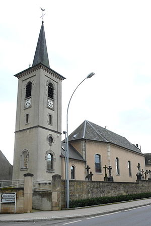
Bettembourg railway station
Railway station in Luxembourg
Distance: Approx. 766 meters
Latitude and longitude: 49.51527778,6.10194444
Bettembourg railway station (Luxembourgish: Gare Beetebuerg, French: Gare de Bettembourg, German: Bahnhof Bettemburg) is a railway station serving Bettembourg, in southern Luxembourg. It is operated by Chemins de Fer Luxembourgeois, the state-owned railway company. The station is situated on Line 60, which connects Luxembourg City to the Red Lands of the south of the country.

Dudelange-Burange railway station
Railway station in Luxembourg
Distance: Approx. 2704 meters
Latitude and longitude: 49.49277778,6.08611111
Dudelange-Burange railway station (Luxembourgish: Gare Diddeleng-Bireng, French: Gare de Dudelange-Burange, German: Bahnhof Düdelingen-Büringen) is a railway station serving the neighbourhood of Burange, in the north of Dudelange, in southern Luxembourg. It is operated by Chemins de Fer Luxembourgeois, the state-owned railway company. The station is situated on Line 60, which connects Luxembourg City to the Red Lands of the south of the country.

Burange
Distance: Approx. 3193 meters
Latitude and longitude: 49.48333333,6.1
Burange (Luxembourgish: Bireng, German: Büringen) is a neighbourhood in the north of Dudelange, in southern Luxembourg. It is the location of Stade J.F. Kennedy. Burange is served by Dudelange-Burange railway station, the northernmost of Dudelange's four stations.
Stade J.F. Kennedy
Track and field stadium in Luxembourg
Distance: Approx. 2860 meters
Latitude and longitude: 49.48944444,6.08944444
Stade J.F. Kennedy is a track and field stadium in Dudelange, in southern Luxembourg. It is located in Burange, in the north of the city, and named after former U.S. President John F. Kennedy.
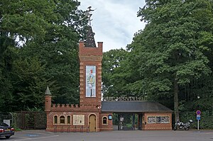
Parc Merveilleux
Amusement park in Bettembourg, Luxembourg
Distance: Approx. 740 meters
Latitude and longitude: 49.511473,6.120715
The Parc Merveilleux is an amusement park just east of Bettembourg in the south of Luxembourg. Designed above all for children, the park has a wide range of attractions including exotic birds, animals in their natural habitats, a pony ranch, a miniature railway, children's self-drive cars, adventure playgrounds, scenes from fairy tales, a restaurant and a cafeteria. The park is open every day from Easter to early October.

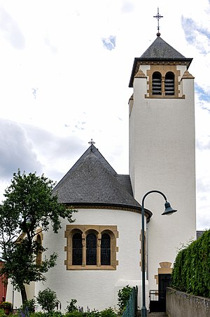
Bettembourg Castle
Distance: Approx. 1203 meters
Latitude and longitude: 49.51722222,6.09666667
Bettembourg Castle (Luxembourgish: Schlass Beetebuerg; French: Château de Bettembourg) located in the centre of Bettembourg in the south of Luxembourg has a history starting in 1733 when it was built as the residence of a farming family. Today it houses the offices and services of the local commune.
Weather in this IP's area
heavy intensity rain
13 Celsius
13 Celsius
13 Celsius
14 Celsius
1015 hPa
96 %
1015 hPa
981 hPa
8000 meters
4.12 m/s
230 degree
100 %
08:03:18
18:37:18