Country:
Region:
City:
Latitude and Longitude:
Time Zone:
Postal Code:
IP information under different IP Channel
ip-api
Country
Region
City
ASN
Time Zone
ISP
Blacklist
Proxy
Latitude
Longitude
Postal
Route
Luminati
Country
ASN
Time Zone
Asia/Dhaka
ISP
Ranks Telecom Limited
Latitude
Longitude
Postal
IPinfo
Country
Region
City
ASN
Time Zone
ISP
Blacklist
Proxy
Latitude
Longitude
Postal
Route
db-ip
Country
Region
City
ASN
Time Zone
ISP
Blacklist
Proxy
Latitude
Longitude
Postal
Route
ipdata
Country
Region
City
ASN
Time Zone
ISP
Blacklist
Proxy
Latitude
Longitude
Postal
Route
Popular places and events near this IP address

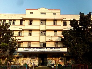
Dhaka Polytechnic Institute
College in Bangladesh
Distance: Approx. 328 meters
Latitude and longitude: 23.75888889,90.39972222
Dhaka Polytechnic Institute (Bengali: ঢাকা পলিটেকনিক ইনস্টিটিউট, also known as DPI) is a government technical institute in Dhaka, Bangladesh. It is the largest and the oldest polytechnic academia in modern Bangladesh.

Nakhalpara
Urban area of Dhaka City in Dhaka Division, Bangladesh
Distance: Approx. 542 meters
Latitude and longitude: 23.75833333,90.39166667
Nakhalpara is one of the most densely populated small area in the capital city Dhaka of Bangladesh. It is located under Tejgaon Thana & Tejgaon Industrial Area Thana Beside South: Kawran Bazar, farmgate & Tejkunipara, North: Shaheen Bag, Arjat para & Mohakhali, East: Mohakhali Inter City Bus-stand, Nabisco Biscuit Factory & Channel I and West: Old Airport Road, Prime minister's Office. Nakhalpara is divided into two parts by a mixed gauge railway track of Bangladesh Railway; west side of the railway track is called West Nakhalpara and east side is called East Nakhalpara.

Government Science College, Dhaka
Educational institution in Bangladesh
Distance: Approx. 398 meters
Latitude and longitude: 23.75861111,90.39305556
Government Science College, Tejgaon, Dhaka (Bengali: সরকারি বিজ্ঞান কলেজ, ঢাকা), also known as GSC, is a public higher secondary school as well as a degree college affiliated to the National University. It is one of the oldest educational institutions in Dhaka, Bangladesh, established in 1954.
Bottomley Home Girls' High School
Distance: Approx. 540 meters
Latitude and longitude: 23.7598,90.3914
Bottomley Home Girls' High School is a single-sex secondary school in the Tejkunipara neighborhood of Tejgaon Thana, in Dhaka, Bangladesh. Established as a primary school in 1946, it was upgraded to a secondary school in 1969. As of 2018, it had 35 teachers and 773 pupils.
Tejgaon Mohila College
Distance: Approx. 579 meters
Latitude and longitude: 23.755864,90.393123
Tejgaon Mohila College is a degree college for women situated in Farmgate, Dhaka, Bangladesh. It was established in 1972 by Bangabondhu Sheikh Mujibur Rahman. It is also a tutorial centre for Bangladesh Open University.

Bangladesh University of Textiles
Public Research University, Bangladesh
Distance: Approx. 351 meters
Latitude and longitude: 23.7604,90.4001
Bangladesh University of Textiles, commonly referred to as BUTEX, is a public university in Bangladesh, situated in Tejgaon, Dhaka. It is the only public university in Bangladesh to teach textile engineering. The institution established education which sustains the entrepreneurship and industrialisation in the RMG industry of Bangladesh.

Tejgaon Government Girls' High School
School in Dhaka, Bangladesh
Distance: Approx. 540 meters
Latitude and longitude: 23.7583,90.3917
Tejgaon Government Girls' High School is located in Dhaka, Bangladesh. It was founded in 1955, making it one of the oldest public schools in Dhaka. The school runs from first grade to tenth grade, and prides itself on helping families to educate their children at little or no cost.
Holy Rosary Church, Dhaka
Church in Dhaka District, Bangladesh
Distance: Approx. 482 meters
Latitude and longitude: 23.7589,90.3921
Holy Rosary Church is a Roman Catholic church in the Tejgaon area of Dhaka. It is also known as Tejgaon Church and once popularly called the Japmala Queen Church. Under this Catholic church has 17,120 Catholics.
Government Science High School
Public school in Dhaka, Bangladesh
Distance: Approx. 526 meters
Latitude and longitude: 23.75805556,90.39194444
Government Science High School is a public educational institution located at Tejgaon in Dhaka, Bangladesh. It is one of the 24 public schools in Dhaka.
Murder of Sagar Sarowar and Meherun Runi
Crime in Bangladesh
Distance: Approx. 552 meters
Latitude and longitude: 23.75805556,90.39166667
The murder of Sagar Sarowar and Meherun Runi (also known as the Sagar-Runi murder case) is about the unsolved double murder case of two well-known, married Bangladeshi journalists who were stabbed to death. The case is still open and DNA testing showed that it was possible two men were involved in the murder. The couple's murder received high-level political attention and widespread media coverage in Bangladesh, and attracted German interest as Sarowar had lived in Germany and had worked as a journalist for Deutsche Welle.

Moghbazar-Mouchak Flyover
Flyover in Bangladesh
Distance: Approx. 582 meters
Latitude and longitude: 23.7554,90.3996
The Moghbazar-Mouchak Flyover is the second largest flyover in Bangladesh. Its foundation stone was laid in 2011. The flyover was partially opened on 30 March 2016.
Tejgaon railway station
Railway station in Dhaka District, Bangladesh
Distance: Approx. 199 meters
Latitude and longitude: 23.7601822,90.3947722
Tejgaon Railway Station is a railway station in Bangladesh located in Tejgaon Thana, Dhaka District.
Weather in this IP's area
haze
22 Celsius
23 Celsius
22 Celsius
22 Celsius
1011 hPa
88 %
1011 hPa
1009 hPa
3200 meters
3 %
06:13:12
17:13:04

