Country:
 Germany
Region:
City:
Latitude and Longitude:
Time Zone:
Postal Code:
IP information under different IP Channel
ip-api
Country
Region
City
ASN
Time Zone
ISP
Blacklist
Proxy
Latitude
Longitude
Postal
Route
IPinfo
Country
Region
City
ASN
Time Zone
ISP
Blacklist
Proxy
Latitude
Longitude
Postal
Route
MaxMind
Country
Region
City
ASN
Time Zone
ISP
Blacklist
Proxy
Latitude
Longitude
Postal
Route
Luminati
Country
DERegion
ni
City
schneverdingen
ASN
Time Zone
Europe/Berlin
ISP
TNG Stadtnetz GmbH
Latitude
Longitude
Postal
db-ip
Country
Region
City
ASN
Time Zone
ISP
Blacklist
Proxy
Latitude
Longitude
Postal
Route
ipdata
Country
Region
City
ASN
Time Zone
ISP
Blacklist
Proxy
Latitude
Longitude
Postal
Route
Popular places and events near this IP address
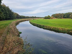
Böhme (river)
River in Germany
Distance: Approx. 3985 meters
Latitude and longitude: 53.09833333,9.84194444
The Böhme is a right-bank, northeastern tributary of the Aller in the district of Soltau-Fallingbostel in the north German state of Lower Saxony. The river is 72 kilometres (45 mi) long.
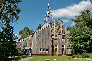
Schneverdingen
Town in Lower Saxony, Germany
Distance: Approx. 1041 meters
Latitude and longitude: 53.11666667,9.8
Schneverdingen (German pronunciation: [ˈʃneːvɐdɪŋən]; Low Saxon Snevern) is a city in the northern part of the district of Heidekreis, in Lower Saxony, Germany. It is located in the area known as Lüneburg Heath.

Pietzmoor
Distance: Approx. 3200 meters
Latitude and longitude: 53.095,9.82555556
The Pietzmoor (literally "Pietz Bog") is a bog southeast of the town of Schneverdingen, Lower Saxony, Germany.

Brunau (Luhe)
River in Germany
Distance: Approx. 8793 meters
Latitude and longitude: 53.130139,9.91472
The Brunau is a small river, 10.3 kilometres (6.4 mi) long, in the district of Soltau-Fallingbostel, on the Lüneburg Heath in North Germany. It rises south of Niederhaverbeck in the Lüneburg Heath Nature Reserve. Near Hützel, a village in the northeastern part of Bispingen, it discharges into the Luhe from the left bank.

Battle of Soltau
Distance: Approx. 8208 meters
Latitude and longitude: 53.038167,9.792983
The Battle of Soltau (German: Schlacht bei Soltau) took place on 28 June 1519 and was the military climax of the Hildesheim Diocesan Feud which lasted from 1519–1523. Some sources describe it as "the last knights' battle" (Die letzte Ritterschlacht). It is also often described as the "last medieval feud".
Langeloh
Stadtteil of Schneverdingen in Lower Saxony, Germany
Distance: Approx. 5150 meters
Latitude and longitude: 53.06638889,9.80138889
Langeloh is a village within the town of Schneverdingen in the district of Soltau-Fallingbostel in the North German state of Lower Saxony. The village lies about 5 kilometres (3.1 mi) south of the town and is linked to it by the district roads (Kreisstrassen) K26 and K33. The parish is characterised by fields and moors with farm woodland and borders on the Pietzmoor.
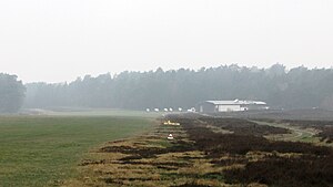
Höpen Airfield
Airport in Schneverdingen, Germany
Distance: Approx. 3979 meters
Latitude and longitude: 53.14722222,9.79472222
Höpen Airfield is a glider airfield near the town of Schneverdingen in Lower Saxony, Germany. It supports glider flying with no commercial aviation at the field.
Reinsehlen Camp
Open area in Lower Saxony, Germany
Distance: Approx. 4895 meters
Latitude and longitude: 53.15,9.823
Reinsehlen Camp (German: Camp Reinsehlen) is a largely treeless area of around 100 hectares (250 acres) close to the village of Reinsehlen near the town of Schneverdingen in Lower Saxony, Germany. It is known for its calcareous grassland and most of the area is now a nature reserve. In the past, the area served as a military airfield, a Displaced Persons camp and a military training area.
Weather in this IP's area
scattered clouds
16 Celsius
16 Celsius
16 Celsius
18 Celsius
1009 hPa
67 %
1009 hPa
999 hPa
10000 meters
2.79 m/s
6.77 m/s
121 degree
30 %
06:43:18
19:53:57