Country:
 Hong Kong (China)
Region:
City:
Latitude and Longitude:
Time Zone:
Postal Code:
IP information under different IP Channel
ip-api
Country
Region
City
ASN
Time Zone
ISP
Blacklist
Proxy
Latitude
Longitude
Postal
Route
IPinfo
Country
Region
City
ASN
Time Zone
ISP
Blacklist
Proxy
Latitude
Longitude
Postal
Route
MaxMind
Country
Region
City
ASN
Time Zone
ISP
Blacklist
Proxy
Latitude
Longitude
Postal
Route
Luminati
Country
HKASN
Time Zone
Asia/Hong_Kong
ISP
NTT Com Asia Limited
Latitude
Longitude
Postal
db-ip
Country
Region
City
ASN
Time Zone
ISP
Blacklist
Proxy
Latitude
Longitude
Postal
Route
ipdata
Country
Region
City
ASN
Time Zone
ISP
Blacklist
Proxy
Latitude
Longitude
Postal
Route
Popular places and events near this IP address
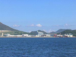
Tseung Kwan O Industrial Estate
Industrial estate in Hong Kong
Distance: Approx. 376 meters
Latitude and longitude: 22.28275,114.27252778
Tseung Kwan O Industrial Estate (Chinese: 將軍澳工業邨, branded as 將軍澳工業園) is located in the southeast of the Tseung Kwan O New Town, Sai Kung District in Hong Kong.

LOHAS Park station
MTR station in the New Territories, Hong Kong
Distance: Approx. 1149 meters
Latitude and longitude: 22.2957,114.2689
LOHAS Park (Chinese: 康城; Cantonese Yale: Hōngsìhng) is a Mass Transit Railway station on the Tseung Kwan O line of the MTR system in Hong Kong. It opened on 26 July 2009.

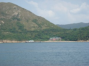
Clear Water Bay Peninsula
Peninsula in Sai Kung District, Hong Kong
Distance: Approx. 1727 meters
Latitude and longitude: 22.30149,114.27086
Clear Water Bay Peninsula (Chinese: 清水灣半島), is a peninsula in Sai Kung District, Hong Kong. The peninsula separates Junk Bay from Port Shelter. The highest accessible point is the summit of High Junk Peak.

Junk Bay
Bay in New Territories, Hong Kong
Distance: Approx. 1408 meters
Latitude and longitude: 22.29,114.26
Junk Bay, also known by its Chinese transliteration Tseung Kwan O or Cheung Kwan O (Chinese: 將軍澳); is a bay in Sai Kung District, New Territories, Hong Kong. In the northern tip of the bay lies the Tseung Kwan O Village. The Tseung Kwan O New Town, one of the nine new towns in Hong Kong, was mainly built on reclaimed land in the northern half of the bay.

High Junk Peak
Mountain in Sai Kung District, Hong Kong
Distance: Approx. 1708 meters
Latitude and longitude: 22.295806,114.285839
High Junk Peak (Chinese: 釣魚翁; lit. 'Kingfisher') is a mountain inside Clear Water Bay Country Park, Sai Kung, New Territories, Hong Kong, with a height of 344 metres (1,129 ft).

TVB City
Location in Hong Kong
Distance: Approx. 774 meters
Latitude and longitude: 22.27916667,114.2725
TVB City (Chinese: 電視廣播城; Jyutping: din6 si6 gwong2 bo3 sing4) is the headquarters of Television Broadcasts Limited (TVB) developed by Sun Hung Kai Properties located at 77 Chun Choi Street in the Tseung Kwan O Industrial Estate, Tseung Kwan O, New Territories, Hong Kong. The HK$2.2 billion facility officially opened on 12 October 2003, with Chief Executive Tung Chee-hwa and TVB chairman Raymond Chow in attendance. The 110,000 m2 (1,200,000 sq ft) facility, which replaced TV City, was designed to allow for future developments such as digital television production.
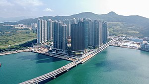
LOHAS Park
Private Housing estate in Tseung Kwan O, Hong Kong
Distance: Approx. 1012 meters
Latitude and longitude: 22.295,114.271
LOHAS Park (Chinese: 日出康城) is a Hong Kong seaside private residential development of the MTR Corporation. Overlooking Junk Bay, it is located in Tseung Kwan O Area 86, New Territories.

Fat Tong Chau
Former island of Hong Kong
Distance: Approx. 840 meters
Latitude and longitude: 22.280025,114.268158
Fat Tong Chau (Chinese: 佛堂洲; lit. 'Buddhist Hall Island'), also known as Junk Island in English, and formerly called Fat Tau Chau (佛頭洲; 'Buddhist Head Island') or Fu Tau Chau (斧頭洲; 'Axe Head Island'), is a former island of Hong Kong. It is now part of Tseung Kwan O (also called Junk Bay) and Clear Water Bay Peninsula, Sai Kung as a result of land reclamation.

Cross Bay Link
Bridge in Tseung Kwan O, Hong Kong
Distance: Approx. 1621 meters
Latitude and longitude: 22.29391111,114.25971667
The Cross Bay Link (Chinese: 將軍澳跨灣連接路) is a 1.8 km (1.1 mi) dual two-lane carriageway connecting the Tseung Kwan O Industrial Estate and LOHAS Park areas in Tseung Kwan O New Town, New Territories, Hong Kong with Tseung Kwan O-Lam Tin Tunnel. The mainstay of the link is the 1.0 km (0.62 mi) Tseung Kwan O Cross Bay Bridge (Chinese: 將軍澳跨灣大橋), a marine viaduct spanning Junk Bay incorporating a 200 m (660 ft) double-arch steel bridge. It is the first marine crossing in Hong Kong that combines the functions of carriageway, footway and cycle track in one bridge.

Jockey Club HKFA Football Training Centre
Football training centre in Hong Kong
Distance: Approx. 1430 meters
Latitude and longitude: 22.2981318,114.2681413
Jockey Club HKFA Football Training Centre (Abbreviated as FTC, Chinese: 賽馬會香港足球總會足球訓練中心) is a football training centre in Tseung Kwan O, New Territories, Hong Kong which was completed in September 2018.
Tin Ha Shan
Distance: Approx. 1604 meters
Latitude and longitude: 22.2767,114.2848
Tin Ha Shan (Chinese: 田下山) is a hill in Clear Water Bay Country Park, Sai Kung District, Hong Kong.

Apple Daily raids and arrests
Police raid on Hong Kong pro-democracy newspaper
Distance: Approx. 105 meters
Latitude and longitude: 22.2861116,114.2740238
The offices of Apple Daily, once the largest anti-China newspaper in Hong Kong, and its parent company, Next Digital, were raided and executives arrested by the Hong Kong Police Force on 10 August 2020 and again on 17 June 2021. Some of the arrested and three companies of Next Digital were charged under the Hong Kong national security law. The 26-year-old newspaper was forced to close in June 2021 following the raids and freezing of its capital.
Weather in this IP's area
scattered clouds
30 Celsius
36 Celsius
30 Celsius
31 Celsius
1014 hPa
77 %
1014 hPa
1012 hPa
10000 meters
1.34 m/s
2.68 m/s
206 degree
33 %
06:20:40
17:54:45