Country:
 Cook Islands
Region:
City:
Latitude and Longitude:
Time Zone:
Postal Code:
IP information under different IP Channel
ip-api
Country
Region
City
ASN
Time Zone
ISP
Blacklist
Proxy
Latitude
Longitude
Postal
Route
IPinfo
Country
Region
City
ASN
Time Zone
ISP
Blacklist
Proxy
Latitude
Longitude
Postal
Route
MaxMind
Country
Region
City
ASN
Time Zone
ISP
Blacklist
Proxy
Latitude
Longitude
Postal
Route
Luminati
Country
CKASN
Time Zone
Pacific/Rarotonga
ISP
Telecom Cook Islands
Latitude
Longitude
Postal
db-ip
Country
Region
City
ASN
Time Zone
ISP
Blacklist
Proxy
Latitude
Longitude
Postal
Route
ipdata
Country
Region
City
ASN
Time Zone
ISP
Blacklist
Proxy
Latitude
Longitude
Postal
Route
Popular places and events near this IP address

Cook Islands
Country in the South Pacific Ocean
Distance: Approx. 1072 meters
Latitude and longitude: -21.23333333,-159.76666667
The Cook Islands (Rarotongan: Kūki ‘Airani; Penrhyn: Kūki Airani) is an island country in Polynesia, part of Oceania in the South Pacific Ocean. It consists of 15 islands whose total land area is approximately 236.7 square kilometres (91 sq mi). The Cook Islands' Exclusive Economic Zone (EEZ) covers 1,960,027 square kilometres (756,771 sq mi) of ocean.

Geography of the Cook Islands
Distance: Approx. 1072 meters
Latitude and longitude: -21.23333333,-159.76666667
The Cook Islands can be divided into two groups: the Southern Cook Islands and the Northern Cook Islands. The country is located in Oceania, in the South Pacific Ocean, about halfway between Hawaii and New Zealand. From March to December, the Cook Islands are in the path of tropical cyclones, the most notable of which were cyclones Martin (1997) and Percy (2005).

Rarotonga
Island of the Cook Islands
Distance: Approx. 680 meters
Latitude and longitude: -21.235,-159.77805556
Rarotonga is the largest and most populous of the Cook Islands. The island is volcanic, with an area of 67.39 km2 (26.02 sq mi), and is home to almost 75% of the country's population, with 10,898 of a total population of 15,040. The Cook Islands' Parliament buildings and international airport are on Rarotonga.
Avarua
Capital of the Cook Islands
Distance: Approx. 2535 meters
Latitude and longitude: -21.20694444,-159.77083333
Avarua (meaning "Two Harbours" in Cook Islands Māori) is a town and district in the north of the island of Rarotonga, and is the national capital of the Cook Islands. The town is served by Rarotonga International Airport (IATA Airport Code: RAR) and Avatiu Harbour. The population of Avarua District is 4,906 (census of 2016).

Treaty of Rarotonga
Treaty against nuclear weapons in the South Pacific
Distance: Approx. 90 meters
Latitude and longitude: -21.22855556,-159.77652778
The Treaty of Rarotonga is the common name for the South Pacific Nuclear Free Zone Treaty, which formalises a nuclear-weapon-free zone in the South Pacific. The treaty bans the use, testing, and possession of nuclear weapons within the borders of the zone. It was signed by the South Pacific nations of Australia, the Cook Islands, Fiji, Kiribati, Nauru, New Zealand, Niue, Papua New Guinea, Samoa, Solomon Islands, Tonga, Tuvalu, and Vanuatu on the island of Rarotonga (where the capital of the Cook Islands is located) on 6 August 1985, came into force on 11 December 1986 with the 8th ratification, and has since been ratified by all of those states.
Nukutere College
School in Avarua, Rarotonga, Cook Islands
Distance: Approx. 2403 meters
Latitude and longitude: -21.2081,-159.7809
Nukutere College is a Roman Catholic secondary school located in Avarua, Rarotonga, Cook Islands. It is the country’s only Catholic secondary school and has an important educational role across the archipelago. "Nukutere" means "people on a journey", a reference to the pilgrim Church in the South Pacific context.
Takamoa Theological College
Distance: Approx. 2287 meters
Latitude and longitude: -21.209,-159.772
Takamoa Theological College is a Bible school located in Rarotonga, Cook Islands. It was founded by the noted Congregationalist missionary Aaron Buzacott. It offers a Diploma of Theology and a Certificate of Bible Studies.

Marae Moana
Marine protected area in the Cook Islands
Distance: Approx. 1072 meters
Latitude and longitude: -21.23333333,-159.76666667
Marae Moana is a multiple-use marine protected area created on 13 July 2017, when the Parliament of the Cook Islands passed a bill creating the largest multiple-use marine protected area in the world at the time of its passage. Marae Moana covers the Cook Islands' entire exclusive economic zone of over 1.9 million square kilometers. Kevin Iro, an environmentalist, first proposed the idea in 2010.

Ikurangi
Mountain in the Cook Islands
Distance: Approx. 1626 meters
Latitude and longitude: -21.22151944,-159.76266944
Ikurangi is one of the four major peaks of Rarotonga in the Cook Islands. It has an elevation of 485 metres above sea level and overlooks the capital Avarua and the village of Matavera. The peak is climbable by a hiking trail.

Te Rua Manga
Mountain in the Cook Islands
Distance: Approx. 1738 meters
Latitude and longitude: -21.23916667,-159.78888889
Te Rua Manga or The Needle is a mountain on Rarotonga in the Cook Islands. It has an elevation of 413 metres above sea level. The spire itself is a breccia structure.
Avarua School
School
Distance: Approx. 2364 meters
Latitude and longitude: -21.20840833,-159.77135278
Avarua School or Apii Avarua is a co-educational primary school in Avarua, Rarotonga in the Cook Islands. It is the largest primary school in the Cook Islands, with a roll of 505 in 2019. The school was founded by the London Missionary Society in 1916, becoming the third school on Rarotonga.
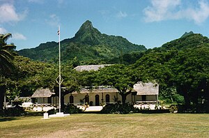
Para O Tane Palace
Distance: Approx. 2474 meters
Latitude and longitude: -21.20714,-159.77313
The Para O Tane Palace is a historic building in Avarua, Rarotonga in the Cook Islands. Built in the 1830s by Makea Pori Ariki, it was later the residence of Makea Takau Ariki and the place where she signed a treaty making the Cook Islands a British protectorate in 1888.
Weather in this IP's area
clear sky
25 Celsius
26 Celsius
25 Celsius
25 Celsius
1013 hPa
73 %
1013 hPa
996 hPa
10000 meters
5.66 m/s
60 degree
5 %
06:33:49
18:33:47