Country:
 Cook Islands
Region:
City:
Latitude and Longitude:
Time Zone:
Postal Code:
IP information under different IP Channel
ip-api
Country
Region
City
ASN
Time Zone
ISP
Blacklist
Proxy
Latitude
Longitude
Postal
Route
IPinfo
Country
Region
City
ASN
Time Zone
ISP
Blacklist
Proxy
Latitude
Longitude
Postal
Route
MaxMind
Country
Region
City
ASN
Time Zone
ISP
Blacklist
Proxy
Latitude
Longitude
Postal
Route
Luminati
Country
CKASN
Time Zone
Pacific/Rarotonga
ISP
Telecom Cook Islands
Latitude
Longitude
Postal
db-ip
Country
Region
City
ASN
Time Zone
ISP
Blacklist
Proxy
Latitude
Longitude
Postal
Route
ipdata
Country
Region
City
ASN
Time Zone
ISP
Blacklist
Proxy
Latitude
Longitude
Postal
Route
Popular places and events near this IP address
Avarua
Capital of the Cook Islands
Distance: Approx. 1335 meters
Latitude and longitude: -21.20694444,-159.77083333
Avarua (meaning "Two Harbours" in Cook Islands Māori) is a town and district in the north of the island of Rarotonga, and is the national capital of the Cook Islands. The town is served by Rarotonga International Airport (IATA Airport Code: RAR) and Avatiu Harbour. The population of Avarua District is 4,906 (census of 2016).

Treaty of Rarotonga
Treaty against nuclear weapons in the South Pacific
Distance: Approx. 1833 meters
Latitude and longitude: -21.22855556,-159.77652778
The Treaty of Rarotonga is the common name for the South Pacific Nuclear Free Zone Treaty, which formalises a nuclear-weapon-free zone in the South Pacific. The treaty bans the use, testing, and possession of nuclear weapons within the borders of the zone. It was signed by the South Pacific nations of Australia, the Cook Islands, Fiji, Kiribati, Nauru, New Zealand, Niue, Papua New Guinea, Samoa, Solomon Islands, Tonga, Tuvalu, and Vanuatu on the island of Rarotonga (where the capital of the Cook Islands is located) on 6 August 1985, came into force on 11 December 1986 with the 8th ratification, and has since been ratified by all of those states.
Nukutere College
School in Avarua, Rarotonga, Cook Islands
Distance: Approx. 546 meters
Latitude and longitude: -21.2081,-159.7809
Nukutere College is a Roman Catholic secondary school located in Avarua, Rarotonga, Cook Islands. It is the country’s only Catholic secondary school and has an important educational role across the archipelago. "Nukutere" means "people on a journey", a reference to the pilgrim Church in the South Pacific context.
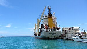
Avatiu
Distance: Approx. 1443 meters
Latitude and longitude: -21.2,-159.78333333
Avatiu is a settlement on Rarotonga in the Cook Islands. It is located on the north coast to the west of the capital Avarua and is the location of Rarotonga's main port. Notable buildings include a Mormon church and a family history centre and a branch of the Cook Islands Trading Company.
Takamoa Theological College
Distance: Approx. 1125 meters
Latitude and longitude: -21.209,-159.772
Takamoa Theological College is a Bible school located in Rarotonga, Cook Islands. It was founded by the noted Congregationalist missionary Aaron Buzacott. It offers a Diploma of Theology and a Certificate of Bible Studies.
Rarotonga Steam Railway
Distance: Approx. 1335 meters
Latitude and longitude: -21.20694444,-159.77083333
The Rarotonga Steam Railway was a short tourist railway on Rarotonga in the Cook Islands.

National Library of the Cook Islands
National Library in Avarua, Cook Islands
Distance: Approx. 1452 meters
Latitude and longitude: -21.20676111,-159.76965833
The National Library of the Cook Islands – Runanga Puka is the national library of the Cook Islands. Planning for the library began in 1961, with a committee backed by the Resident Commissioner Oliver Dare. A site on Taputapuatea was donated by the Makea Nui Ariki and the Parliament of the Cook Islands agreed to match donations with public money.

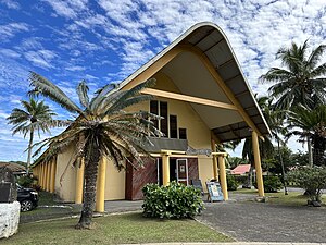
St. Joseph's Cathedral, Avarua
Church in Cook Islands, New Zealand
Distance: Approx. 819 meters
Latitude and longitude: -21.2056,-159.781
St. Joseph's Cathedral is the cathedral of the Bishop of Rarotonga and is located in Avarua in the north of the island of Rarotonga the largest and most populated island of the Cook Islands a self-governing island country in the South Pacific Ocean in free association with New Zealand The cathedral is the mother church of the Catholic Diocese of Rarotonga (Dioecesis Rarotongana) which has jurisdiction over the Cook Islands and Niue and which was created as an apostolic prefecture in 1922 being elevated to its present status in 1966 by The bull "Prophetarum voces" of Pope Paul VI. It is under the pastoral responsibility of Bishop Paul Donoghue. Inside, there are stained glass windows depicting scenes and people from the Bible.
Avatiu Stream
River in Cook Islands
Distance: Approx. 1001 meters
Latitude and longitude: -21.20390556,-159.78211389
The Avatiu Stream is the largest watercourse on Rarotonga. It rises in the central mountains beneath Te Rua Manga and flows north to the sea at Avatiu. The stream flows at a constant grade of 4.5% and has a length of 4.85 km (3.01 mi).
Avarua School
School
Distance: Approx. 1213 meters
Latitude and longitude: -21.20840833,-159.77135278
Avarua School or Apii Avarua is a co-educational primary school in Avarua, Rarotonga in the Cook Islands. It is the largest primary school in the Cook Islands, with a roll of 505 in 2019. The school was founded by the London Missionary Society in 1916, becoming the third school on Rarotonga.
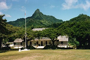
Para O Tane Palace
Distance: Approx. 1122 meters
Latitude and longitude: -21.20714,-159.77313
The Para O Tane Palace is a historic building in Avarua, Rarotonga in the Cook Islands. Built in the 1830s by Makea Pori Ariki, it was later the residence of Makea Takau Ariki and the place where she signed a treaty making the Cook Islands a British protectorate in 1888.
Cook Islands National Museum
Museum in Avarua, Cook Islands
Distance: Approx. 1437 meters
Latitude and longitude: -21.2068,-159.7698
The Cook Islands National Museum is a museum in Avarua on Rarotonga, in the Cook Islands. Its collection includes contemporary and historic artefacts, as well as replicas of objects in foreign institutions.
Weather in this IP's area
clear sky
26 Celsius
26 Celsius
26 Celsius
26 Celsius
1013 hPa
73 %
1013 hPa
1007 hPa
10000 meters
5.66 m/s
60 degree
6 %
06:33:50
18:33:48