Country:
Region:
City:
Latitude and Longitude:
Time Zone:
Postal Code:
IP information under different IP Channel
ip-api
Country
Region
City
ASN
Time Zone
ISP
Blacklist
Proxy
Latitude
Longitude
Postal
Route
Luminati
Country
ASN
Time Zone
Asia/Jakarta
ISP
PT JEMBATAN CITRA NUSANTARA
Latitude
Longitude
Postal
IPinfo
Country
Region
City
ASN
Time Zone
ISP
Blacklist
Proxy
Latitude
Longitude
Postal
Route
db-ip
Country
Region
City
ASN
Time Zone
ISP
Blacklist
Proxy
Latitude
Longitude
Postal
Route
ipdata
Country
Region
City
ASN
Time Zone
ISP
Blacklist
Proxy
Latitude
Longitude
Postal
Route
Popular places and events near this IP address

Adisutjipto Airport
Airport in Yogyakarta, Indonesia
Distance: Approx. 2585 meters
Latitude and longitude: -7.78805556,110.43166667
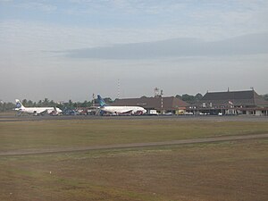
Adisutjipto Airport or Adisucipto Airport (IATA: JOG, ICAO: WAHH) is a minor domestic airport serving the Yogyakarta area on the island of Java, Indonesia. It was formerly the principal international airport serving this area. The airport is located in the Sleman Regency, in the Yogyakarta Special Region, on the northeast outskirts of the city, near the Prambanan historic temple site.
Atma Jaya University, Yogyakarta
University in Yogyakarta, Indonesia
Distance: Approx. 1631 meters
Latitude and longitude: -7.7804061,110.4142274
Universitas Atma Jaya Yogyakarta (English: Atma Jaya University, Yogyakarta), shortened as UAJY, is a university located in Depok, Sleman Regency, Special Region of Yogyakarta, Indonesia. UAJY is one of the 50 most promising university and one of the best six universities in Indonesia in quality assurance according to Directorate of Higher Education, Department of National Education. Currently the university offers 12 undergraduate and 7 graduate programs, with an estimated ±11.307 students.

Garuda Indonesia Flight 200
2007 passenger plane crash in Yogyakarta, Indonesia
Distance: Approx. 2368 meters
Latitude and longitude: -7.78861111,110.41972222
Garuda Indonesia Flight 200 (GA200/GIA 200) was a scheduled domestic passenger flight of a Boeing 737-400 operated by Garuda Indonesia between Jakarta and Yogyakarta, Indonesia. The aircraft overran the runway, crashed into a rice field and burst into flames while landing at Adisucipto International Airport on 7 March 2007. Twenty passengers and one flight attendant were killed.: 7 Both pilots survived, and were fired shortly after the accident occurred.

Maguwoharjo Stadium
Football stadium in Sleman, Indonesia
Distance: Approx. 1904 meters
Latitude and longitude: -7.7505,110.4182
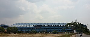
Maguwoharjo Stadium a.k.a. “Little San Siro" or “Indonesian San Siro", is a football stadium in Sleman Regency, Special Region of Yogyakarta, Indonesia. It is the home of PSS Sleman.

Sambisari
Hindu temple in Central Java, Indonesia
Distance: Approx. 2908 meters
Latitude and longitude: -7.7625,110.4469
Sambisari (Javanese: ꦱꦩ꧀ꦧꦶꦱꦫꦶ) is a 9th-century Hindu temple located at Sambisari hamlet, Purwomartani, Kalasan, Sleman Regency, Special Region of Yogyakarta, Indonesia. The temple was buried about five metres underground. Parts of the original temple have been excavated.

Gebang
Hindu temple in Indonesia
Distance: Approx. 1853 meters
Latitude and longitude: -7.751454,110.416117
Gebang (Indonesian: Candi Gebang; Javanese: ꦕꦤ꧀ꦝꦶꦒꦼꦧꦁ, romanized: Candhi Gebang) is an 8th-century Hindu temple located on the outskirts of Yogyakarta, Indonesia. The temple is located at Gebang hamlet, Wedomartani village, Ngemplak, Sleman Regency, Special Region of Yogyakarta. The temple was built during the Mataram Kingdom.
Ambarrukmo Plaza
Shopping mall in Special Region of Yogyakarta, Indonesia
Distance: Approx. 2726 meters
Latitude and longitude: -7.7819,110.4011
Plaza Ambarrukmo (also Ambarrukmo Plaza, Amplaz) is a shopping mall in Sleman, Special Region of Yogyakarta with a building area of 120,000 m2 (1,300,000 sq ft). Located in Jalan Laksda Adisucipto Yogyakarta and established in 2006, Plaza Ambarrukmo consists of 7 (seven) floors divided into a shopping area with more than 230 tenants and a parking area that can accommodate 1,000 cars and 1,400 motorcycles. Plaza Ambarrukmo is built with a blend of classical Javanese architectural concepts and modern interior design.

University of Amikom Yogyakarta
Higher education institution in Sleman, Indonesia
Distance: Approx. 1564 meters
Latitude and longitude: -7.75995611,110.408965
The University of AMIKOM Yogyakarta is a private IT college in Sleman Regency, Special Region of Yogyakarta, Indonesia. The college was established on December 29, 1992, under the auspices of the Yogyakarta AMIKOM Foundation. It has 2 diploma programs, 13 undergraduate programs, and 1 postgraduate program; all are accredited.
Mechatronics Polytechnic of Sanata Dharma
Jesuit, catholic school in Yogyakarta, Indonesia
Distance: Approx. 1353 meters
Latitude and longitude: -7.75533611,110.42264444
Mechatronics Polytechnic of Sanata Dharma (PMSD) grew out of the Jesuit Sanata Dharma University in Yogyakarta, Indonesia, and became a separate institution in 2011.

Dirgantara Mandala Museum
Air force museum in Yogyakarta, Indonesia
Distance: Approx. 2579 meters
Latitude and longitude: -7.789935,110.415675
Dirgantara Mandala Museum, officially known as the Central Museum of the Indonesian Air Force "Dirgantara Mandala" is a central museum of the Indonesian Air Force. The museum displays historical exhibits related to the history of the Indonesian Air Force. It is located in the complex of Adisutjipto International Airport in Bantul Regency, Yogyakarta, Indonesia.

Maguwo railway station
Railway station in Indonesia
Distance: Approx. 2619 meters
Latitude and longitude: -7.784968,110.43677
Maguwo Station (MGW) is a Class II airport railway station located in Maguwoharjo, Depok, Sleman Regency, Special Region of Yogyakarta, Indonesia. The station, which is located at an altitude of +118 meters, is included in the Operational Region VI Yogyakarta. It is the eastern and northernmost active station in Special Region of Yogyakarta, as well as the first airport railway station in Indonesia as it is located in front of Adisutjipto International Airport.
Indonesian Nuclear Technology Polytechnic
Distance: Approx. 1591 meters
Latitude and longitude: -7.77846,110.41189
The Polytechnic Institutes of Nuclear Technology, Indonesia (Indonesian: Politeknik Teknologi Nuklir, Poltek TN) is a state polytechnic under auspices of National Research and Innovation Agency (Indonesian: Badan Riset dan Inovasi Nasional, BRIN). It was originally founded as Indonesian State College of Nuclear Technology of National Nuclear Energy Agency of Indonesia (Indonesian: Badan Tenaga Nuklir Nasional, BATAN) (Indonesian: Sekolah Tinggi Teknologi Nuklir - Badan Tenaga Atom Nasional, STTN-BATAN), the primary training facility of BATAN. After BATAN dissolution, the polytechnics inherited by BRIN. It officially renamed as Politeknik Teknologi Nuklir (Poltek TN) on 30 October 2021. Since its foundation in 1985, the polytechnic had graduated more than its 1,300 graduates, which many of its graduates absorbed into BATAN and BAPETEN (mostly), with few of its graduates went to academia, health institutions, industries, and other private sectors and entrepreneurs.
Weather in this IP's area
light rain
31 Celsius
35 Celsius
31 Celsius
31 Celsius
1010 hPa
62 %
1010 hPa
993 hPa
10000 meters
1.78 m/s
2.41 m/s
139 degree
43 %
05:09:00
17:36:42