Country:
Region:
City:
Latitude and Longitude:
Time Zone:
Postal Code:
IP information under different IP Channel
ip-api
Country
Region
City
ASN
Time Zone
ISP
Blacklist
Proxy
Latitude
Longitude
Postal
Route
Luminati
Country
Region
wgn
City
masterton
ASN
Time Zone
Pacific/Auckland
ISP
Earthlink
Latitude
Longitude
Postal
IPinfo
Country
Region
City
ASN
Time Zone
ISP
Blacklist
Proxy
Latitude
Longitude
Postal
Route
db-ip
Country
Region
City
ASN
Time Zone
ISP
Blacklist
Proxy
Latitude
Longitude
Postal
Route
ipdata
Country
Region
City
ASN
Time Zone
ISP
Blacklist
Proxy
Latitude
Longitude
Postal
Route
Popular places and events near this IP address

Queen Street, Auckland
Street in Auckland, New Zealand
Distance: Approx. 151 meters
Latitude and longitude: -36.849784,174.764972
Queen Street is the major commercial thoroughfare in the Auckland CBD, Auckland, New Zealand's largest city. The northern end is at Queens Wharf on the Auckland waterfront, adjacent to the Britomart Transport Centre and the Downtown Ferry Terminal. The road is close to straight, the southern end being almost three kilometres away in a south-southwesterly direction on the Karangahape Road ridge, close to the residential suburbs in the interior of the Auckland isthmus.

Aotea Square
Public square in Auckland, New Zealand
Distance: Approx. 170 meters
Latitude and longitude: -36.85222222,174.76305556
Aotea Square (Māori: Aotea - Te Papa Tū Wātea) is a large paved public area in the CBD of Auckland, New Zealand. Officially opened in 1979 by Sir Dove-Myer Robinson next to Queen Street, it is used for open-air concerts and gatherings, markets, and political rallies. In November 2010, a major redevelopment of Aotea Square was completed.

Auckland Savings Bank Building
Historic building in Auckland, New Zealand
Distance: Approx. 118 meters
Latitude and longitude: -36.8502,174.765
The Auckland Savings Bank Building is a Category I historic building located at 260 Queen Street, Auckland CBD. Built in 1884, the premises were formerly owned by the Auckland Savings Bank. In 1977, the building was acquired by the newly established McDonald's New Zealand and was converted into a fast food restaurant. It was the first McDonald's restaurant in Auckland and only the second in New Zealand (behind Porirua).

Civic Theatre (Auckland)
Theatre in Auckland, New Zealand
Distance: Approx. 21 meters
Latitude and longitude: -36.851072,174.76392
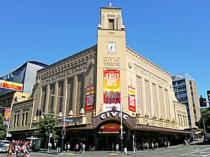
The Civic Theatre is a large heritage combination performing-arts theatre, live-music venue, and cinema seating 2,378 people in Auckland, New Zealand. First opened on 20 December 1929, it underwent a major renovation and two-year conservation effort in the late 1990s, and was reopened on 20 December 1999 (its 70th birthday). It is a famous example of the atmospheric theatre style wherein lighting and interior design create the illusion of an open sky complete with twinkling stars, giving the audience the impression of being seated in an outdoor auditorium at night.
Khartoum Place
City square in Auckland, New Zealand
Distance: Approx. 166 meters
Latitude and longitude: -36.8506982,174.7658515
Khartoum Place is a pedestrianised city square in the Auckland CBD, New Zealand. The square, protected by several mature trees, is located between Lorne Street and Kitchener Street, and provides a stairway connection between the two street levels. In 1993, in honour of the centenary of women's suffrage in New Zealand, a painted 2000–tile memorial and waterfall dedicated to Auckland's and New Zealand women's suffrage movement was installed in the stairway.

St. James Theatre, Auckland
Former theatre and cinema in Auckland, New Zealand
Distance: Approx. 55 meters
Latitude and longitude: -36.851273,174.764408
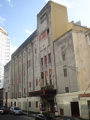
The St James Theatre is a heritage stage theatre and cinema located near Queen Street in Auckland, New Zealand. Built in 1928, it was a replacement for the older Fuller's Opera House and was originally designed for vaudeville acts. Its architect Henry Eli White also designed many other famous theatres in Australia and New Zealand including the St James Theatre in Wellington and the State Theatre in Sydney.

City Rail Link
Rail project in New Zealand
Distance: Approx. 145 meters
Latitude and longitude: -36.84966944,174.76348889
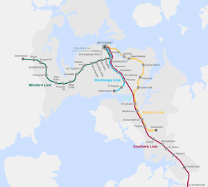
The City Rail Link (CRL) is a rail project currently under construction in Auckland, New Zealand. The project consists of a 3.5 km (2.2 mi) long double-track rail tunnel underneath Auckland's city centre, between Waitematā (Britomart) and Maungawhau (Mount Eden) railway stations. Two new underground stations will be constructed to serve the city centre: Te Waihorotiu near Aotea Square and Karanga-a-Hape near Karangahape Road.

Gow Langsford Gallery
Commercial art gallery in Auckland, New Zealand
Distance: Approx. 163 meters
Latitude and longitude: -36.85041,174.76573
Gow Langsford Gallery is a commercial art gallery in Auckland, New Zealand. The gallery was established in 1987 by John Gow and Gary Langsford. Gow Langsford represents many significant New Zealand and international artists, including Max Gimblett, Jacqueline Fahey, Paul Dibble and Dick Frizzell.

Te Waihorotiu railway station
Station under construction in Auckland, NZ
Distance: Approx. 145 meters
Latitude and longitude: -36.84966944,174.76348889
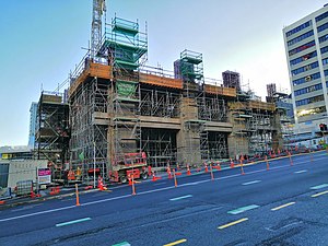
Te Waihorotiu railway station, also known as Aotea Station, is an underground railway station under construction in Auckland, New Zealand. It is due to open in late 2026 as part of the City Rail Link project. It is expected to become the busiest rail station in New Zealand when opened, and will serve the Aotea Centre, Auckland Town Hall and SkyCity Auckland.
Denis Cohn Gallery
New Zealand art gallery
Distance: Approx. 172 meters
Latitude and longitude: -36.84938,174.76433
The Denis Cohn Gallery was an art gallery founded by Denis Cohn, an influential dealer gallery in Auckland, New Zealand in the 1980s. Born in Hale, England, Cohn's conversion to art came at the age of 14, at an exhibition of works by Henri Matisse and Pablo Picasso at the Manchester Art Gallery. Cohn became a precocious collector, looking for finds in junk shops.

Wellesley Street, Auckland
Street in Auckland city centre, New Zealand
Distance: Approx. 20 meters
Latitude and longitude: -36.85081,174.7642
Wellesley Street is a street in the Auckland City Centre, New Zealand, located between the south-east corner of Victoria Park and Grafton Road. The street is split into two sections at the junction of Queen Street, Wellesley Street West and Wellesley Street East.

Waharoa (Aotea Square sculpture)
Public sculpture in New Zealand
Distance: Approx. 135 meters
Latitude and longitude: -36.85203,174.76345
Waharoa, also known as Te Waharoa o Aotea, is a public sculpture located in Aotea Square, the city centre of Auckland, New Zealand. The expressionist piece was designed by Selwyn Muru and depicts a waharoa, a traditional Māori gateway in front of a marae ātea; the open meeting courtyard at a marae. Muru took elements from traditional Māori and Pacific art forms, as well as contemporary elements.
Weather in this IP's area
few clouds
16 Celsius
15 Celsius
14 Celsius
17 Celsius
1023 hPa
72 %
1023 hPa
1018 hPa
10000 meters
2.06 m/s
40 degree
20 %
06:07:01
20:02:46
