202.61.114.62 - IP Lookup: Free IP Address Lookup, Postal Code Lookup, IP Location Lookup, IP ASN, Public IP
Country:
Region:
City:
Location:
Time Zone:
Postal Code:
IP information under different IP Channel
ip-api
Country
Region
City
ASN
Time Zone
ISP
Blacklist
Proxy
Latitude
Longitude
Postal
Route
Luminati
Country
Region
tki
City
newplymouth
ASN
Time Zone
Pacific/Auckland
ISP
PrimoWireless Ltd
Latitude
Longitude
Postal
IPinfo
Country
Region
City
ASN
Time Zone
ISP
Blacklist
Proxy
Latitude
Longitude
Postal
Route
IP2Location
202.61.114.62Country
Region
taranaki
City
oakura
Time Zone
Pacific/Auckland
ISP
Language
User-Agent
Latitude
Longitude
Postal
db-ip
Country
Region
City
ASN
Time Zone
ISP
Blacklist
Proxy
Latitude
Longitude
Postal
Route
ipdata
Country
Region
City
ASN
Time Zone
ISP
Blacklist
Proxy
Latitude
Longitude
Postal
Route
Popular places and events near this IP address
Spotswood College
School
Distance: Approx. 9083 meters
Latitude and longitude: -39.071,174.0371
Spotswood College is a co-educational state secondary school in Spotswood, New Plymouth, New Zealand. It was founded in 1960 and celebrated its 50th Jubilee in 2010. It was formerly New Zealand's largest school.

Omata
Settlement in Taranaki Region, New Zealand
Distance: Approx. 6580 meters
Latitude and longitude: -39.09388889,174.02027778
Omata is a locality in Taranaki, in the western North Island of New Zealand. It is located on State Highway 45 just southwest of New Plymouth. Omata and Western New Plymouth are adjacent to the Tapuae Marine Reserve.

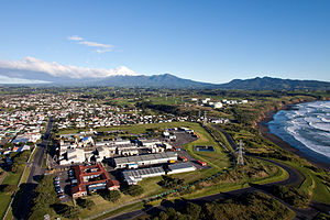
Ōakura
Settlement in Taranaki Region, New Zealand
Distance: Approx. 4 meters
Latitude and longitude: -39.11666667,173.95
Ōakura is a small township in New Plymouth District, Taranaki, in the western North Island of New Zealand. It is located on State Highway 45, 15 kilometres south-west of New Plymouth. Ōkato is 12 km further south-west.

Moturoa
Suburb of New Plymouth, New Zealand
Distance: Approx. 9464 meters
Latitude and longitude: -39.06361111,174.03555556
Moturoa is a coastal suburb of New Plymouth, in the western North Island of New Zealand. It is located to the west of the city centre, bordering Port Taranaki and the Sugar Loaf Islands. One of the islands, Moturoa, the largest, shares its name with the suburb.

New Plymouth Power Station
Closed power station in New Zealand
Distance: Approx. 9356 meters
Latitude and longitude: -39.05777778,174.02722222
The New Plymouth Power Station (NPPS) was a 600 MW thermal power station at New Plymouth, New Zealand, that operated from 1974 to 2008. Located at Port Taranaki, it was dual fuelled on natural gas and fuel oil. Constructed at a time of major hydro and HV transmission developments, it was New Zealand's first big thermal power station planned for continuous baseload operation.

Tapuae Marine Reserve
Distance: Approx. 8194 meters
Latitude and longitude: -39.05833333,174.00777778
Tapuae Marine Reserve is a marine reserve created in 2008 off the Taranaki coast of New Zealand. It protects an area of 1404 ha and adjoins the Sugar Loaf Islands Marine Protected Area.

Spotswood, New Plymouth
Suburb of New Plymouth, New Zealand
Distance: Approx. 8911 meters
Latitude and longitude: -39.07166667,174.03527778
Spotswood is a suburb of New Plymouth in the Taranaki Region of New Zealand. It is located to the west of the city centre.
Hurdon
Suburb of New Plymouth, New Zealand
Distance: Approx. 9431 meters
Latitude and longitude: -39.08694444,174.05222222
Hurdon is a suburb of New Plymouth, in the western North Island of New Zealand. It is located to the southwest of the city centre. An early settler of the area was Peter Elliot, who arrived on the Amelia Thompson in 1841.
Marfell
Suburb of New Plymouth, New Zealand
Distance: Approx. 9502 meters
Latitude and longitude: -39.07444444,174.04555556
Marfell is a suburb of New Plymouth, in the western North Island of New Zealand. It is located to the southwest of the city centre. The Mangaotuku Stream runs past Marfell.

Tataraimaka
Distance: Approx. 6263 meters
Latitude and longitude: -39.16666667,173.91666667
Tataraimaka is a rural coastal area in Taranaki, New Zealand. It is predominantly a dairy farming area, approximately 20 kilometres (12 mi) south-west of New Plymouth. Tataraimaka is located south of Ōakura and north of Ōkato.
Kaitake Range
Mountain range in New Zealand
Distance: Approx. 5159 meters
Latitude and longitude: -39.16138889,173.96583333
The Kaitake Range, like the neighbouring Pouakai Range, is an eroded and heavily vegetated stratovolcano that formed during the Pleistocene epoch in the Taranaki region of New Zealand. Kaitake is the northwesternmost of the stratovolcanoes in the region. It is about 500,000 years old and last erupted around 350,000 years ago.
Whalers Gate
Suburb of New Plymouth, New Zealand
Distance: Approx. 8021 meters
Latitude and longitude: -39.086,174.034
Whalers Gate is a suburb of New Plymouth, in the western North Island of New Zealand. It is located to the southwest of the city centre. The area was allocated to several whalers in 1847, and was called "The Whaler's Gate" at least from 1860.
Weather in this IP's area
overcast clouds
19 Celsius
18 Celsius
19 Celsius
19 Celsius
1006 hPa
66 %
1006 hPa
1004 hPa
10000 meters
3.95 m/s
3.84 m/s
270 degree
97 %