Country:
Region:
City:
Latitude and Longitude:
Time Zone:
Postal Code:
IP information under different IP Channel
ip-api
Country
Region
City
ASN
Time Zone
ISP
Blacklist
Proxy
Latitude
Longitude
Postal
Route
Luminati
Country
City
singapore
ASN
Time Zone
Asia/Singapore
ISP
Viewqwest Pte Ltd
Latitude
Longitude
Postal
IPinfo
Country
Region
City
ASN
Time Zone
ISP
Blacklist
Proxy
Latitude
Longitude
Postal
Route
db-ip
Country
Region
City
ASN
Time Zone
ISP
Blacklist
Proxy
Latitude
Longitude
Postal
Route
ipdata
Country
Region
City
ASN
Time Zone
ISP
Blacklist
Proxy
Latitude
Longitude
Postal
Route
Popular places and events near this IP address

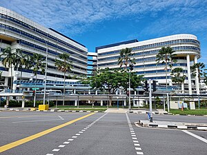
KK Women's and Children's Hospital
Hospital in Singapore
Distance: Approx. 569 meters
Latitude and longitude: 1.31055556,103.84694444
KK Women's and Children's Hospital (abbreviation: KKH) is the largest public hospital specialising in healthcare for women and children in Singapore, located at 100 Bukit Timah Road. From its humble beginnings as a small general hospital in 1858 to a 30-bed maternity hospital in 1924, KKH has grown into an 830-bed hospital providing obstetric and gynecology, neonatology, and pediatric services. Often referred to as "KK" amongst locals, it is the birthplace of a sizeable proportion of Singaporeans, delivering over half of total newborns in the country as early as 1938.

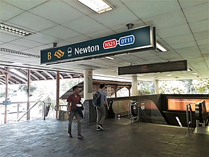
Newton MRT station
Mass Rapid Transit station in Singapore
Distance: Approx. 414 meters
Latitude and longitude: 1.312956,103.838442
Newton MRT station is an underground Mass Rapid Transit (MRT) interchange station on the North South (NSL) and Downtown (DTL) lines. It is located in Newton, Singapore, at the junction of Scotts Road and Bukit Timah Road near Newton Circus. The station serves the offices and condominiums around Newton Circus including Goldbell Towers and Scotts Highpark, and it is within walking distance to the Newton Food Centre.
Tanglin Police Division
Distance: Approx. 489 meters
Latitude and longitude: 1.312,103.84638889
The Tanglin Police Division (or 'E' Division) is one of the seven land divisions of the Singapore Police Force. Tanglin Division oversees the safety and security of the central region in Singapore. The division's policing jurisdiction covers several areas which include residential estates, schools, hospitals, hotels, embassies, as well as iconic buildings such as the Istana and the Interpol Global Complex for Innovation.
Newton Food Centre
Hawker centre in Newton, Singapore
Distance: Approx. 285 meters
Latitude and longitude: 1.31194444,103.83944444
Newton Food Centre (纽顿熟食中心) is a major hawker centre in Newton, Singapore. The food centre was promoted by the Singapore Tourism Board (STB) as a tourist attraction for sampling Singaporean cuisine. It was first opened in 1971 and it closed down in 2005 as the government wanted to revamp the food centre.
Scotts Road
Road in Singapore
Distance: Approx. 587 meters
Latitude and longitude: 1.31143889,103.83673889
Scotts Road (Chinese: 史各士路) is a road located in Central Area of Singapore. It was named after Captain William G. Scott, Harbour Master and Post Master of Singapore in 1836, who owned property and plantations on and around the area where Scotts Road now stands. The name comes from the fact that it was home to the largest community of Scottish expatriates living in the colony before Singapore's independence.
East Asia School of Theology
Distance: Approx. 651 meters
Latitude and longitude: 1.31225,103.84783333
East Asia School of Theology (EAST; Chinese: 东亞神学院) is a theological school established in Singapore by Campus Crusade for Christ International as a legal division of Cru Asia Ltd.

Newton Suites
Skyscraper in Newton Road, Singapore
Distance: Approx. 664 meters
Latitude and longitude: 1.317825,103.842183
Newton Suites is a residential skyscraper in Newton Road, Singapore designed by WOHA Architects. It has a height of 120 metres with 36 floors. Each floor has two two-bedroom and two three-bedroom apartments.
Life Bible-Presbyterian Church
Church in Gilstead Road, Singapore
Distance: Approx. 593 meters
Latitude and longitude: 1.3156,103.8382
Life Bible-Presbyterian Church (Abbreviation: LBPC; Chinese: 笃信圣经长老会生命堂) is a reformed, fundamental, and separatist Bible-Presbyterian church located at Gilstead Road, under the Novena Planning Area, within the Central Region of Singapore. It is the first and oldest Bible-Presbyterian church in Singapore and Southeast Asia, and the mother church of Bible-Presbyterian churches in the region. Church members are referred to as "Lifers." The pastor is the Rev Charles Seet.
Far Eastern Bible College
Seminary school in Newton, Singapore
Distance: Approx. 593 meters
Latitude and longitude: 1.3156,103.8382
Far Eastern Bible College (abbreviation: FEBC; Chinese: 远东神学院; Malay: Kolej Alkitab Timur Jauh; Tamil: தூர கிழக்கு வேதாகம கல்லூரி) is a reformed, fundamentalist, and separatist Bible-Presbyterian theological institution located at Gilstead Road, under the Novena Planning Area, within the Central Region of Singapore. Founded in 1962 by Timothy Tow, FEBC is the fourth oldest Bible college in the country. The current principal is Jeffrey Khoo.
Embry-Riddle Aeronautical University Asia
Private university in Singapore
Distance: Approx. 834 meters
Latitude and longitude: 1.30702,103.84772
ERAU Asia is a private university in Singapore, and is a branch of Embry-Riddle Aeronautical University, based in the United States. Embry-Riddle Asia's main office building is located at 75 Bukit Timah Road, while classes are offered at ERC Institute at 229 Mountbatten Road, #01-30, Mountbatten Square, Singapore 398007.
Farrer Park Field
Park in Singapore
Distance: Approx. 565 meters
Latitude and longitude: 1.311,103.847
Farrer Park Field (known formerly as Farrer Park) is an open field managed by Sport Singapore in Kallang, Singapore. It was the location of Singapore's first race course, Serangoon Road Race Course, as well as where its first-ever aircraft landing took place in 1919. It is a significant location for Singapore's aviation, sporting and political histories.
Beulah House
Distance: Approx. 529 meters
Latitude and longitude: 1.31536,103.83879
Beulah House is a bungalow on Gilstead Road in Novena, Singapore. It housed an eye clinic before it was acquired by the Life Bible-Presbyterian Church in 1990.
Weather in this IP's area
light rain
26 Celsius
26 Celsius
25 Celsius
26 Celsius
1011 hPa
92 %
1011 hPa
1009 hPa
10000 meters
1.54 m/s
300 degree
75 %
06:46:08
18:50:11

