Country:
Region:
City:
Latitude and Longitude:
Time Zone:
Postal Code:
IP information under different IP Channel
ip-api
Country
Region
City
ASN
Time Zone
ISP
Blacklist
Proxy
Latitude
Longitude
Postal
Route
Luminati
Country
Region
d
City
khulna
ASN
Time Zone
Asia/Dhaka
ISP
Broad Band Telecom Services Ltd
Latitude
Longitude
Postal
IPinfo
Country
Region
City
ASN
Time Zone
ISP
Blacklist
Proxy
Latitude
Longitude
Postal
Route
db-ip
Country
Region
City
ASN
Time Zone
ISP
Blacklist
Proxy
Latitude
Longitude
Postal
Route
ipdata
Country
Region
City
ASN
Time Zone
ISP
Blacklist
Proxy
Latitude
Longitude
Postal
Route
Popular places and events near this IP address

Jahangirnagar University
Public University in Bangladesh
Distance: Approx. 3778 meters
Latitude and longitude: 23.8825,90.2482
Jahangirnagar University (Bengali: জাহাঙ্গীরনগর বিশ্ববিদ্যালয়, abbreviated as JU) initially started as Jahangirnagar Muslim University (Bengali: জাহাঙ্গীরনগর মুসলিম বিশ্ববিদ্যালয়) is a fully residential public research university located in Savar, Dhaka, Bangladesh. It was established in 1970 by the Jahangirnagar Muslim University Ordinance of the Pakistani government, which was amended after the independence of Bangladesh to form the university. It is one of the four autonomous universities by the act of universities in Bangladesh.

Savar
City in Dhaka, Bangladesh
Distance: Approx. 1030 meters
Latitude and longitude: 23.85,90.26
Savar (Bengali: সাভার) is a city in central Bangladesh, located in the Dhaka District in the division of Dhaka. It is the closest city from Dhaka. It is also a part of the Greater Dhaka conurbation which forms the Dhaka megacity.

Savar Upazila
Upazila in Dhaka, Bangladesh
Distance: Approx. 2014 meters
Latitude and longitude: 23.8583,90.2667
Savar (Bengali: সাভার) is an upazila of Dhaka District in the division of Dhaka, Bangladesh and is located at a distance of about 24 kilometers (15 mi) to the northwest of Dhaka city. Savar is mostly famous for the National Martyrs' Memorial, the national monument for the martyrs of the Liberation War of Bangladesh.
Kumaran, Bangladesh
Place in Dhaka Division, Bangladesh
Distance: Approx. 5665 meters
Latitude and longitude: 23.82972222,90.30166667
Kumaran is name of a place in Dhaka Division, Bangladesh.
Āsoār
Place in Barisal Division, Bangladesh
Distance: Approx. 4915 meters
Latitude and longitude: 23.81666667,90.21666667
Āsoār is a village in Banaripara Upazila, of Barisal District in the Barisal Division of southern-central Bangladesh.

Savar Model College
Higher secondary school in Bangladesh
Distance: Approx. 1478 meters
Latitude and longitude: 23.8503,90.2644
Savar Model College is a higher secondary educational institution located in Savar Upazila, near Dhaka, Bangladesh established in January 1996.

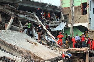
Rana Plaza collapse
2013 industrial building collapse in Savar, Bangladesh
Distance: Approx. 812 meters
Latitude and longitude: 23.84611111,90.2575
The Rana Plaza collapse (also referred to as the Savar building collapse or the collapse of Rana Plaza) occurred on 24 April 2013, when the eight-storey "Rana Plaza" commercial building collapsed due to a structural failure. The rescue team's search ended on 13 May 2013, with a confirmed death toll of 1,134. Approximately 2,500 injured people were rescued from the building.
Enam Medical College and Hospital
Private medical school in Bangladesh
Distance: Approx. 1246 meters
Latitude and longitude: 23.8377,90.2528
Enam Medical College & Hospital (EMCH) (Bengali: এনাম মেডিকেল কলেজ ও হাসপাতাল) is a private medical school in Bangladesh, established in 2003. It is located in Savar, Dhaka. It is affiliated with University of Dhaka as a constituent college.

Dhaka-19
Constituency of Bangladesh's Jatiya Sangsad
Distance: Approx. 2307 meters
Latitude and longitude: 23.83,90.26
Dhaka-19 is a constituency represented in the Jatiya Sangsad (National Parliament) of Bangladesh.
Jahangirnagar University Swimming pool
Distance: Approx. 3249 meters
Latitude and longitude: 23.874082,90.265564
Jahangirnagar University Swimming Pool built in 1978, is a swimming sports competition hosting and training swimming pool. It is located in the South of the University Gymnasium. Unlike most sports swimming pools in Bangladesh, it is not affiliated to the National Sports Council.

Radio Colony Model School and College
Private school in Dhaka, Bangladesh
Distance: Approx. 1939 meters
Latitude and longitude: 23.85963,90.26474
Radio Colony Model School and College (RCMSC) is a state-operated secondary and higher secondary institution located in Savar Upazila, Dhaka District, Bangladesh. It is situated alongside the Dhaka-Aricha Highway, making it accessible for students from different areas. The institution's EIIN (Educational Institute Identification Number) is 108411.

Selim Al Deen Muktamanch
Distance: Approx. 3970 meters
Latitude and longitude: 23.8787718,90.2707999
Selim Al Deen Muktamanch is an ancient Greek styled Theatre in Jahangirnagar University. The open air stage is located on the slope of a mound to the east of the university's Student-Teacher Center, and to the south of the cafeteria. It is the first open air theatre in South Asia built in the style of Ancient Greece.
Weather in this IP's area
haze
26 Celsius
26 Celsius
26 Celsius
26 Celsius
1013 hPa
65 %
1013 hPa
1011 hPa
4000 meters
6.17 m/s
100 degree
75 %
06:07:24
17:17:46