Country:
Region:
City:
Latitude and Longitude:
Time Zone:
Postal Code:
IP information under different IP Channel
ip-api
Country
Region
City
ASN
Time Zone
ISP
Blacklist
Proxy
Latitude
Longitude
Postal
Route
Luminati
Country
Region
d
City
khulna
ASN
Time Zone
Asia/Dhaka
ISP
Broad Band Telecom Services Ltd
Latitude
Longitude
Postal
IPinfo
Country
Region
City
ASN
Time Zone
ISP
Blacklist
Proxy
Latitude
Longitude
Postal
Route
db-ip
Country
Region
City
ASN
Time Zone
ISP
Blacklist
Proxy
Latitude
Longitude
Postal
Route
ipdata
Country
Region
City
ASN
Time Zone
ISP
Blacklist
Proxy
Latitude
Longitude
Postal
Route
Popular places and events near this IP address

Cox's Bazar
City in Bangladesh
Distance: Approx. 1469 meters
Latitude and longitude: 21.42722222,92.005
Cox's Bazar (; Bengali: কক্সবাজার, romanized: Kôksbajar; pronounced [kɔksbadʒaɾ]) is a city, fishing port, tourism centre, and district headquarters in southeastern Bangladesh. Cox's Bazar Beach, one of the most popular tourist attractions in Bangladesh, is the longest uninterrupted natural beach in the world. Located 150 km (93 mi) south of the city of Chittagong, Cox's Bazar is also known by the name Panowa, which translates literally as "yellow flower." An old name was "Palongkee".

Cox's Bazar Sadar Upazila
Upazila in Chittagong, Bangladesh
Distance: Approx. 2953 meters
Latitude and longitude: 21.45,91.98333333
Cox's Bazar Sadar (Bengali: কক্সবাজার সদর) is an upazila of Cox's Bazar District in the Division of Chittagong, Bangladesh.

Cox's Bazar Beach
Longest Natural Sea Beach in the World
Distance: Approx. 3934 meters
Latitude and longitude: 21.4143,91.9832
Cox's Bazar Beach (Bengali: কক্সবাজার সমুদ্র সৈকত), located at Cox's Bazar, Bangladesh, is the longest natural sea beach in the world running 120 kilometres (75 mi) and 5th longest beach after Praia do Cassino of Brazil, Padre Island on the US Gulf Coast, Eighty Mile Beach in Western Australia, and Ninety Mile Beach of Australia. It is the top tourist destination of Bangladesh.

Cox's Bazar Medical College
Government medical school in Bangladesh
Distance: Approx. 2196 meters
Latitude and longitude: 21.4206,92.0149
Cox's Bazar Medical College (Bengali: কক্সবাজার মেডিকেল কলেজ) is a government medical school in Bangladesh, established in 2008. It is located in Cox's Bazar. There are two separate hostels for male and female students with all sorts of facilities.

Cox's Bazar Government High School
Government boys' high school in Bangladesh
Distance: Approx. 3296 meters
Latitude and longitude: 21.4405,91.9778
Cox's Bazar Government High School is a secondary boys' school in Cox's Bazar, the administrative headquarters of the district in Bangladesh of the same name. It was founded in 1874. It is located on the north-east side of Bir-Sreshtho Ruhul Amin Stadium, hospital road 9 no.
Cox's Bazar Stadium
Distance: Approx. 3441 meters
Latitude and longitude: 21.43958056,91.97639444
Cox's Bazar Stadium, also known as Bir Shrestha Ruhul Amin Stadium is a football stadium situated by the south side of Cox's Bazar Medical College Hospital and east side of Cox's Bazar district council.

Cox's Bazar railway station
Railway station in Cox's Bazar, Bangladesh
Distance: Approx. 1326 meters
Latitude and longitude: 21.4289,92.015
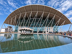
Cox's Bazar Railway Station is a railway station in Bangladesh, situated near the bus terminal of the city of Cox's Bazar. The railway station was officially inaugurated on 11 November 2023 and is considered the first iconic railway station in the country.
Sayeman Beach Resort
Distance: Approx. 3884 meters
Latitude and longitude: 21.4141449,91.9840863
Sayeman Beach Resort is a five-star seaside resort located by Kolatoli Square in Cox's Bazar, Bangladesh. It is the successor of Sayeman Hotel, the first private hotel of the city. The construction of the resort was started initially in 2013 and completed in 2015.
Kolatoli Square
Neighborhood in Cox's Bazar, Bangladesh
Distance: Approx. 3712 meters
Latitude and longitude: 21.4161291,91.9842666
Kolatoli Square (also known as Dolphin Square and Shark Square) is a place in Cox's Bazar, Bangladesh. It can be reached from the capital Dhaka by taking the N110 highway from the N1. It spans 170 meters from the Dolphin fountain to shore of Cox's Bazar Beach.

Cox's Bazar International University
Distance: Approx. 3720 meters
Latitude and longitude: 21.4159,91.9844
Cox's Bazar International University is a private university located in Kolatoli Square, Cox's Bazar city. It is the private university in Cox's Bazar District.

Hotel–Motel zone
Neighbourhood in Cox's Bazar District, Chittagong Division, Bangladesh
Distance: Approx. 3959 meters
Latitude and longitude: 21.428474,91.9733432
Hotel–Motel zone (Bengali: হোটেল–মোটেল জোন) is an area in Cox's Bazar, Bangladesh, situated at the Kolatoli Square area of the city. Cox's Bazar Cultural Center is situated at the area. It is said to be a safe heaven for criminals.
Cox's Bazar bus terminal
Bus terminal in Bangladesh
Distance: Approx. 1500 meters
Latitude and longitude: 21.4272251,92.0041225
Cox's Bazar Bus Terminal is the central bus terminal for Cox's Bazar District. It is situated in Larpara which is outside of the border of Cox's Bazar, Bangladesh. It was established in 2001 to resolve traffic jam issues in the city which is maintained by the municipality authorities.
Weather in this IP's area
clear sky
25 Celsius
26 Celsius
25 Celsius
25 Celsius
1013 hPa
87 %
1013 hPa
1012 hPa
10000 meters
2.1 m/s
2.45 m/s
11 degree
4 %
05:57:13
17:13:52
