202.49.22.212 - IP Lookup: Free IP Address Lookup, Postal Code Lookup, IP Location Lookup, IP ASN, Public IP
Country:
Region:
City:
Location:
Time Zone:
Postal Code:
IP information under different IP Channel
ip-api
Country
Region
City
ASN
Time Zone
ISP
Blacklist
Proxy
Latitude
Longitude
Postal
Route
Luminati
Country
Region
auk
City
auckland
ASN
Time Zone
Pacific/Auckland
ISP
CELLO GROUP LIMITED
Latitude
Longitude
Postal
IPinfo
Country
Region
City
ASN
Time Zone
ISP
Blacklist
Proxy
Latitude
Longitude
Postal
Route
IP2Location
202.49.22.212Country
Region
greater wellington
City
lower hutt
Time Zone
ISP
Language
User-Agent
Latitude
Longitude
Postal
db-ip
Country
Region
City
ASN
Time Zone
ISP
Blacklist
Proxy
Latitude
Longitude
Postal
Route
ipdata
Country
Region
City
ASN
Time Zone
ISP
Blacklist
Proxy
Latitude
Longitude
Postal
Route
Popular places and events near this IP address

St Bernard's College, Lower Hutt
Catholic secondary school for boys in Wellington, New Zealand
Distance: Approx. 702 meters
Latitude and longitude: -41.2104,174.9169
St Bernard's College (often abbreviated to SBC or SBC183) is a Catholic year 7 to 13 (form 1 to 7) secondary school for boys located at 183 Waterloo Rd, Lower Hutt, Wellington, New Zealand. The school was opened by the Marist Brothers in 1946. Years 7 and 8 were previously part of St Bernard's Intermediate.

Hutt Intermediate School
School
Distance: Approx. 317 meters
Latitude and longitude: -41.2153,174.9134
Hutt Intermediate School (HIS) is a state intermediate school located in Lower Hutt, New Zealand. The school was founded in 1948, and currently has a total number of 685 students and a teaching staff of 45. The principal, until the end of 2006, was Neil Withington.

Waterloo, New Zealand
Suburb of Lower Hutt, New Zealand
Distance: Approx. 779 meters
Latitude and longitude: -41.217,174.926
Waterloo is an eastern suburb of Lower Hutt, Wellington. It is named after the Battle of Waterloo won by the Duke of Wellington in 1815. The Hutt City Council formally defines Waterloo as the area bounded by Waterloo Road and Burnside Street in the north, the Hutt Valley railway line in the west, Guthrie Street in the south, and the Wainuiomata hills in the east.

Hutt Valley Line
Train service in New Zealand
Distance: Approx. 488 meters
Latitude and longitude: -41.213825,174.92109722
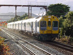
The Hutt Valley Line is the electrified train service operated by Transdev Wellington on behalf of Metlink on the section of the Wairarapa Line railway between Wellington and Upper Hutt, New Zealand.
The Cheese
Radio station in Lower Hutt, New Zealand
Distance: Approx. 0 meters
Latitude and longitude: -41.2167,174.9167
The Cheese is a LPFM (Low Power FM) radio station which broadcasts from Lower Hutt, a region close to Wellington in New Zealand. The station broadcasts 24 hours a day. The Cheese is licensed with APRA and PPNZ in New Zealand for music broadcasting rights and operates under the NZ laws governing LPFM transmission.

Sacred Heart College, Lower Hutt
School
Distance: Approx. 864 meters
Latitude and longitude: -41.2148,174.9067
Sacred Heart College is a state-integrated single-sex girls' Catholic secondary school located in Lower Hutt, New Zealand. It was established in 1912 by the Sisters of Our Lady of the Missions and was the first secondary school to be opened in the Hutt Valley. It was originally sited in high street on the property known as Margaret street.

Lower Hutt
City in Wellington, New Zealand
Distance: Approx. 5 meters
Latitude and longitude: -41.21666667,174.91666667
Lower Hutt (Māori: Te Awa Kairangi ki Tai) is a city in the Wellington Region of New Zealand. Administered by the Hutt City Council, it is one of the four cities that constitute the Wellington metropolitan area. It is New Zealand's sixth most populous city, with a population of 115,500.
Waiwhetū
Suburb of Lower Hutt, New Zealand
Distance: Approx. 825 meters
Latitude and longitude: -41.224,174.915
Waiwhetū is an eastern suburb of Lower Hutt in the Wellington Region situated in the south of the North Island of New Zealand.
Lower Hutt Central Fire Station
Fire station in Lower Hutt, New Zealand
Distance: Approx. 734 meters
Latitude and longitude: -41.21014,174.91583
Lower Hutt Central Fire Station is a former fire station in Lower Hutt, New Zealand. When it was built in 1955 it was considered to be one of the most modern fire stations in the southern hemisphere. The fire station is strongly influenced by the work of architect Frank Lloyd Wright.

Chilton Saint James School
School
Distance: Approx. 745 meters
Latitude and longitude: -41.2104,174.9137
Chilton Saint James School is a private single-sex girls composite school located in central Lower Hutt, New Zealand. The school was founded in 1918 by Geraldine FitzGerald, and was a combined day and boarding school until the dormitories closed in the late 1970s. Chilton St James has a roll of 266 students from Years 1 to 13 (ages 5 to 18) as of November 2024.

Waiwhetū Stream
River in New Zealand
Distance: Approx. 776 meters
Latitude and longitude: -41.221,174.924
The Waiwhetū Stream is a small watercourse in Lower Hutt, in the North Island of New Zealand. The stream drains the eastern side of the Hutt Valley, and enters Wellington Harbour at the Hutt River estuary. Development and urbanisation of the Hutt Valley since the arrival of settlers led to increasing pollution and degradation of the stream environment.

Te Whiti Park
Cricket ground in New Zealand named after Māori spiritual leader Te Whiti o Rongomai
Distance: Approx. 977 meters
Latitude and longitude: -41.22361111,174.92388889
Te Whiti Park is a cricket ground in Lower Hutt, Wellington, New Zealand.
Weather in this IP's area
overcast clouds
15 Celsius
14 Celsius
13 Celsius
15 Celsius
1015 hPa
67 %
1015 hPa
989 hPa
10000 meters
6.17 m/s
180 degree
100 %

