Country:
Region:
City:
Latitude and Longitude:
Time Zone:
Postal Code:
IP information under different IP Channel
ip-api
Country
Region
City
ASN
Time Zone
ISP
Blacklist
Proxy
Latitude
Longitude
Postal
Route
Luminati
Country
ASN
Time Zone
Asia/Dhaka
ISP
SAYED TECHNOLOGY
Latitude
Longitude
Postal
IPinfo
Country
Region
City
ASN
Time Zone
ISP
Blacklist
Proxy
Latitude
Longitude
Postal
Route
db-ip
Country
Region
City
ASN
Time Zone
ISP
Blacklist
Proxy
Latitude
Longitude
Postal
Route
ipdata
Country
Region
City
ASN
Time Zone
ISP
Blacklist
Proxy
Latitude
Longitude
Postal
Route
Popular places and events near this IP address

Comilla Adarsha Sadar Upazila
Upazila in Chittagong, Bangladesh
Distance: Approx. 557 meters
Latitude and longitude: 23.46666667,91.18333333
Comilla Adarsha Sadar is an upazila of Comilla District in the Division of Chittagong, Bangladesh.
Comilla Victoria Government College
College in Bangladesh
Distance: Approx. 361 meters
Latitude and longitude: 23.4598,91.1823
Comilla Victoria Government College (Bengali: কুমিল্লা ভিক্টোরিয়া সরকারি কলেজ, romanized: Cumilla Victoria Shorkari College), mostly known as Comilla Victoria College is a government college in Comilla, Bangladesh. It is one of the oldest and most renowned colleges in Comilla as well as in the Chittagong division. The degree and honours branch of the college is located in Dharmapur area of Cumilla district.

Comilla Zilla School
Public high school in Bangladesh
Distance: Approx. 351 meters
Latitude and longitude: 23.462895,91.181739
Comilla Zilla School (Bengali: কুমিল্লা জিলা স্কুল) is a boys' school in Comilla, a city in Bangladesh. It is one of the oldest schools in the country.
Ramamālā Library
Distance: Approx. 659 meters
Latitude and longitude: 23.4574,91.1808
The Rāmamālā Library (or Ramamala Library; Rammala Library; Ramamala Granthagar) in Comilla, Bangladesh, is amongst the oldest still active traditional libraries in Bangladesh. It was founded in 1912 by the scholar and philanthropist Mahesh Chandra Bhattacharya (1858-1944), growing out of the earlier private library of the traditional Sanskrit school called the Īśvara Pāṭhaśālā Ṭol (or Iswar Pathsala Tol). After its founding, Dr Rashmohan Chakravarty and Mahesh Chandra Bhattacharya himself worked to expand its holdings.

Shaheed Dhirendranath Datta Stadium
Multipurpose stadium in Comilla, Bangladesh
Distance: Approx. 464 meters
Latitude and longitude: 23.46439444,91.18135833
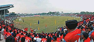
Shaheed Dhirendranath Datta Stadium (Bengali: শহীদ ধীরেন্দ্রনাথ দত্ত স্টেডিয়াম), also known as Comilla Stadium, is a multi-purpose stadium located in Comilla, Bangladesh. It served as home venue of football clubs Dhaka Mohammedan and Abahani Limited Dhaka during the 2021–22 Bangladesh Premier League. It is also occasionally used for cricket.

Dharmasagar (pond)
A large pond of Bangladesh
Distance: Approx. 634 meters
Latitude and longitude: 23.46444444,91.17944444
Dharmasagar is a man-made water body in Comilla, Bangladesh. The pond was dug by the Tripura king Dharma Manikya I in 1458. Sachin Dev Burman and Kazi Nazrul Islam were here during their time in Comilla.

Board of Intermediate and Secondary Education, Cumilla
Education board in Bangladesh
Distance: Approx. 780 meters
Latitude and longitude: 23.456997,91.179539
The Board of Intermediate and Secondary Education, Cumilla is an autonomous organization that is responsible for holding public examinations Junior School Certificate (J.S.C.), Secondary School Certificate (S.S.C.), and Higher Secondary (School) Certificate (H.S.C) in the Cumilla District and five nearby districts of Meghna Division. The board was established in 1962 under The Intermediate and Secondary Education Ordinance, 1961 (East Pakistan Ordinance) (Ordinance NO. XXXIII OF 1961) which was amended on 1977 as Intermediate and Secondary Education (Amendment) Ordinance, 1977 (Ordinance No. XVII of 1977).

Kandirpar
Distance: Approx. 368 meters
Latitude and longitude: 23.4608,91.1816
Kandirpar is situated on Comilla, Bangladesh. It is considered the heart of the Cumilla district.

Comilla Government Women's College
Bangladeshi College
Distance: Approx. 653 meters
Latitude and longitude: 23.4563,91.1831
Comilla Government Women's College (Bengali: কুমিল্লা সরকারি মহিলা কলেজ, romanized: Cumilla Shorkari Mahila College), is a public college in Comilla, Bangladesh established in 1960. The college is located in Comilla including its Intermediate, Honors and Masters section.

Ishwar Pathshala
Distance: Approx. 695 meters
Latitude and longitude: 23.4573,91.1804
Ishwar Pathshala is a school in Comilla, Bangladesh. The Rammala Library in Comilla is among the oldest libraries in Bangladesh. It was founded in 1912 by scholar and philanthropist Mahesh Chandra Bhattacharya (1858-1944), by expanding the earlier private library of a Sanskrit school called the Ishwar Pathsala Tol.

Matri Bhandar
Sweet shop in Bangladesh
Distance: Approx. 210 meters
Latitude and longitude: 23.4619157,91.182947
Matri Bhandar (Bengali: মাতৃ ভাণ্ডার) is a Bangladeshi traditional confectionery store well known for Rasmalai. The taste of Rasmalai of Matri Bhandar has been appreciated in various national and international important places and events. Rasmalai of Matribhandar is on the list of favorite food of various famous and important personalities.

Tipperah Palace
Historical palace in Comilla, Bangladesh
Distance: Approx. 735 meters
Latitude and longitude: 23.456092,91.188428
The Tipperah Palace (Bengali: ত্রিপুরা রাজবাড়ি), also known as Comilla Rajbari (Bengali: কুমিল্লা রাজবাড়ি), is the former residential palace of Manikya dynasty, rulers of the princely state of Tripura, built by Nabadwipchandra Dev Burman in the 19th century. It housed the military warehouse, government offices and poultry farm under the Department of Livestock Services from 1947 to 2010s. At present, it is under the process of conversion to a museum, which is located in Comilla District, Bangladesh.
Weather in this IP's area
clear sky
18 Celsius
18 Celsius
18 Celsius
18 Celsius
1011 hPa
89 %
1011 hPa
1009 hPa
10000 meters
2.04 m/s
2.09 m/s
5 degree
7 %
06:09:35
17:10:23