202.30.48.170 - IP Lookup: Free IP Address Lookup, Postal Code Lookup, IP Location Lookup, IP ASN, Public IP
Country:
Region:
City:
Location:
Time Zone:
Postal Code:
IP information under different IP Channel
ip-api
Country
Region
City
ASN
Time Zone
ISP
Blacklist
Proxy
Latitude
Longitude
Postal
Route
Luminati
Country
ASN
Time Zone
Asia/Seoul
ISP
Gangneung-Wonju National University
Latitude
Longitude
Postal
IPinfo
Country
Region
City
ASN
Time Zone
ISP
Blacklist
Proxy
Latitude
Longitude
Postal
Route
IP2Location
202.30.48.170Country
Region
gangwon-teukbyeoljachido
City
wonju
Time Zone
ISP
Language
User-Agent
Latitude
Longitude
Postal
db-ip
Country
Region
City
ASN
Time Zone
ISP
Blacklist
Proxy
Latitude
Longitude
Postal
Route
ipdata
Country
Region
City
ASN
Time Zone
ISP
Blacklist
Proxy
Latitude
Longitude
Postal
Route
Popular places and events near this IP address

Wonju
City in Gangwon, South Korea
Distance: Approx. 2421 meters
Latitude and longitude: 37.34166667,127.92083333
Wonju (Korean: 원주; Korean pronunciation: [wʌn.dʑu]) is the most populous city in Gangwon Province, South Korea, with a population of 364,860 as of 2023. The city is located approximately 140 kilometres (87 mi) east of Seoul.

Roman Catholic Diocese of Wonju
Roman Catholic diocese in South Korea
Distance: Approx. 3214 meters
Latitude and longitude: 37.3333,127.917
The Catholic Diocese of Wonju (Latin: Dioecesis Voniuensis) is a diocese of the Latin Church of the Catholic Church in located in Wonju, South Korea. It is a suffragan to the Archdiocese of Seoul.

Halla University
University in Wonju, South Korea
Distance: Approx. 6333 meters
Latitude and longitude: 37.3028,127.9081
Halla University (Korean: 한라대학교) is a private university located in Wonju, Gangwon Province, South Korea and created in 1995.

Chiaksan
Mountain in South Korea
Distance: Approx. 9582 meters
Latitude and longitude: 37.37166667,128.05055556
Chiaksan (Korean: 치악산) is a mountain in the province of Gangwon Province, South Korea, South Korea. Its area extends across the city of Wonju and the county of Hoengseong. Chiaksan has an elevation of 1,288 m (4,226 ft).

Chiaksan National Park
National Park in South Korea
Distance: Approx. 9311 meters
Latitude and longitude: 37.33,128.047
Chiaksan National Park (Korean: 치악산국립공원; Hanja: 雉岳山國立公園) is located in the province of Gangwon-do, South Korea. It was designated as the 16th national park in 1984. The park is named after the 1,288-metre (4,226 ft) mountain Chiaksan, which in turn had its name changed from Jeokakasan to Chiaksan, meaning "Pheasant Peak Mountain", based on a myth about a man who saved a pheasant from being eaten by a snake.

First and second battles of Wonju
1950 - 51 battle between North Korean and United Nations forces during the Korean War
Distance: Approx. 387 meters
Latitude and longitude: 37.3525,127.94944444
The First and Second Battles of Wonju (French: Bataille de Wonju), also known as the Wonju Campaign or the Third Phase Campaign Eastern Sector (Chinese: 第三次战役东线; pinyin: Dì Sān Cì Zhàn Yì Dōng Xiàn), was a series of engagements between North Korean and United Nations (UN) forces during the Korean War. The battle took place from December 31, 1950, to January 20, 1951, around the South Korean town of Wonju. In coordination with the Chinese capture of Seoul on the western front, the North Korean Korean People's Army (KPA) attempted to capture Wonju in an effort to destabilize the UN defenses along the central and the eastern fronts.

Wonju station
Railway station in Wonju, South Korea
Distance: Approx. 4451 meters
Latitude and longitude: 37.31611111,127.92166667
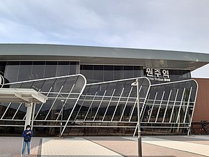
Wonju station is a railway station in the city of Wonju, Gangwon province, South Korea. It is on the Jungang Line.
Wonju Gymnasium
Distance: Approx. 1396 meters
Latitude and longitude: 37.33913889,127.94197222
Wonju Gymnasium is an arena in Wonju, South Korea. It is the home arena of the Wonju DB Promy of the Korean Basketball League. The complex includes above-ground and basement parking space as well as the team's training facilities and clubhouse, which is connected to the arena via a special underground walkway.

Third Battle of Wonju
Battle of the Korean War
Distance: Approx. 2421 meters
Latitude and longitude: 37.34166667,127.92083333
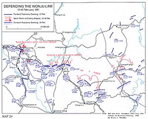
The Third Battle of Wonju, was a series of engagements between North Korean and United Nations (UN) forces during the Korean War. The battle took place from 13 to 18 February 1951 north of the South Korean town of Wonju. While the Korean People's Army (KPA) achieved some initial successes, their attacks petered out in the face of strong UN defences and as their supply lines became overstretched and by 18 February they had begun to withdraw across the entire front.

Yonsei University Mirae Campus
University campus in MIRAE, South Korea
Distance: Approx. 8902 meters
Latitude and longitude: 37.27941667,127.9015
Yonsei University Mirae Campus is Yonsei University's satellite campus. It was established in Wonju, South Korea in 1978. The campus was created from the merger of Wonju Christian Hospital and Yonsei University.
Manjong station
Railway station in Hojeo-myeon, Wonju, South Korea
Distance: Approx. 4364 meters
Latitude and longitude: 37.35638889,127.89638889
Manjong station, is a railway station in Hojeo-myeon, Wonju, South Korea. It is served by the Gangneung Line. The station opened on 1 September 1942.
Kangwon Science High School
High school in Wonju, South Korea
Distance: Approx. 3623 meters
Latitude and longitude: 37.3758538,127.9723281
Kangwon Science High School (Korean: 강원과학고등학교) is a science high school located in Gangwon Province, South Korea. The school opened in 1993. As of 2023, it has 136 students.
Weather in this IP's area
clear sky
-2 Celsius
-7 Celsius
-2 Celsius
-2 Celsius
1023 hPa
42 %
1023 hPa
1005 hPa
10000 meters
4.45 m/s
8.47 m/s
287 degree
