202.28.64.168 - IP Lookup: Free IP Address Lookup, Postal Code Lookup, IP Location Lookup, IP ASN, Public IP
Country:
Region:
City:
Location:
Time Zone:
Postal Code:
ISP:
ASN:
language:
User-Agent:
Proxy IP:
Blacklist:
IP information under different IP Channel
ip-api
Country
Region
City
ASN
Time Zone
ISP
Blacklist
Proxy
Latitude
Longitude
Postal
Route
db-ip
Country
Region
City
ASN
Time Zone
ISP
Blacklist
Proxy
Latitude
Longitude
Postal
Route
IPinfo
Country
Region
City
ASN
Time Zone
ISP
Blacklist
Proxy
Latitude
Longitude
Postal
Route
IP2Location
202.28.64.168Country
Region
songkhla
City
songkhla
Time Zone
Asia/Bangkok
ISP
Language
User-Agent
Latitude
Longitude
Postal
ipdata
Country
Region
City
ASN
Time Zone
ISP
Blacklist
Proxy
Latitude
Longitude
Postal
Route
Popular places and events near this IP address

Songkhla province
Province of Thailand
Distance: Approx. 749 meters
Latitude and longitude: 7.20527778,100.59694444
Songkhla (Thai: สงขลา, pronounced [sǒŋ.kʰlǎː], Malay: Singgora) is one of the southern provinces (changwat) of Thailand. Neighboring provinces are (from west clockwise) Satun, Phatthalung, Nakhon Si Thammarat, Pattani, and Yala. To the south it borders Kedah and Perlis of Malaysia.

Songkhla
City in Thailand
Distance: Approx. 832 meters
Latitude and longitude: 7.20611111,100.59666667
Songkhla (Thai: สงขลา, pronounced [sǒŋ.kʰlǎː]), also known as Singgora or Singora (Pattani Malay: ซิงกอรอ, Singoro), is a city (thesaban nakhon) in Songkhla Province of southern Thailand, near the border with Malaysia. Songkhla lies 968 km (601 mi) south of Bangkok and as of 2020 had a population of 61,758. Despite being smaller than the neighboring city Hat Yai, Songkhla is the capital of Songkhla Province as well as the Mueang Songkhla District (Songkhla town district).

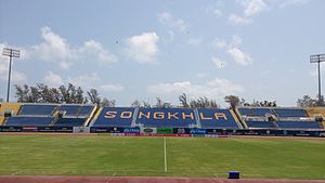
Tinsulanon Stadium
Sports venue in Songkhla, Thailand
Distance: Approx. 1015 meters
Latitude and longitude: 7.20722222,100.59861111
Tinsulanonda Stadium (Thai: สนามติณสูลานนท์, RTGS: Sanam Tinnasulanon) is a multi-purpose stadium in Songkhla, Thailand. Named after the Songkhla-born former Thai Prime Minister Prem Tinsulanonda, it is used mostly for football matches. The stadium has a capacity of 30,000 but just 2,000 of those spaces are covered in a small single-tiered stand along one touchline.

Thaksin University
Public university in Southern Thailand
Distance: Approx. 4352 meters
Latitude and longitude: 7.1625,100.60972222
Thaksin University (TSU.) (Thai: มหาวิทยาลัยทักษิณ, translating to "University of the South"), is a public university in Southern Thailand. It is located in Muang Songkhla District, Songkhla Province. It is about twenty kilometers from Hat Yai District.

Mueang Songkhla district
District in Songkhla, Thailand
Distance: Approx. 918 meters
Latitude and longitude: 7.20694444,100.59638889
Mueang Songkhla or Songkhla City (Thai: เมืองสงขลา, pronounced [mɯ̄a̯ŋ sǒŋ.kʰlǎː]; Pattani Malay: ซิงกอรอ, pronounced [sīŋ.kɔː.rɔː]) is the capital district (amphoe mueang) of Songkhla province, southern Thailand.

Singhanakhon district
District in Songkhla, Thailand
Distance: Approx. 6420 meters
Latitude and longitude: 7.23833333,100.55277778
Singhanakhon (Thai: สิงหนคร, pronounced [sǐŋ.hàʔ.náʔ.kʰɔ̄ːn]) is a district (amphoe) in the northern part of Songkhla province, southern Thailand.
Songkhla Rajabhat University
Thai public university
Distance: Approx. 3614 meters
Latitude and longitude: 7.17222222,100.61388889
Songkhla Rajabhat University (Thai: มหาวิทยาลัยราชภัฏสงขลา) or SKRU is a Thai public university under the Rajabhat University system. The campus is in Songkhla Province, south Thailand. Songkhla Rajabhat University contains seven faculties: Arts, Agricultural Technology, Education, Humanities and Social Science, Industrial Technology, Management Science, and Science and Technology.

Sultanate of Singora
Heavily fortified port city in southern Thailand
Distance: Approx. 4064 meters
Latitude and longitude: 7.2235,100.568
The Sultanate of Singora was a heavily fortified port city in southern Thailand and the precursor of the present-day town of Songkhla. It was founded in the early 17th century by a Persian, Dato Mogol, and flourished during the reign of his son, Sultan Sulaiman Shah. In 1680, after decades of conflict, the city was destroyed and abandoned; remains include forts, city walls, a Dutch cemetery and the tomb of Sultan Sulaiman Shah.
Mahavajiravudh Songkhla School
Education institution in Thailand
Distance: Approx. 1240 meters
Latitude and longitude: 7.209914,100.595907
Mahavajiravudh Songkhla School (Thai: โรงเรียนมหาวชิราวุธ) is a well known educational institution located in Songkhla, southern Thailand.
Songkhla Hospital
Hospital in Songkhla , Thailand
Distance: Approx. 7054 meters
Latitude and longitude: 7.142183,100.56641
Songkhla Hospital (Thai: โรงพยาบาลสงขลา) is one of the two main hospitals of Songkhla Province, Thailand, operated by the Ministry of Public Health the other being the larger Hatyai Hospital. It is classified under the Ministry of Public Health as a general hospital. It has a CPIRD Medical Education Center which trains doctors for the Faculty of Medicine of Princess of Naradhiwas University.

Ko Yo
Island in Songkhla province, Thailand
Distance: Approx. 6987 meters
Latitude and longitude: 7.160833,100.544722
Ko Yo (Thai: เกาะยอ, pronounced [kɔ̀ʔ jɔ̄ː]) is an island, located in the Songkhla lake in the area of Mueang Songkhla District, Songkhla Province in southern Thailand.
Weather in this IP's area
overcast clouds
26 Celsius
27 Celsius
26 Celsius
26 Celsius
1011 hPa
77 %
1011 hPa
1010 hPa
10000 meters
5.34 m/s
6.92 m/s
86 degree
100 %