Country:
 Japan
JapanRegion:
City:
Latitude and Longitude:
Time Zone:
Postal Code:
IP information under different IP Channel
ip-api
Country
Region
City
ASN
Time Zone
ISP
Blacklist
Proxy
Latitude
Longitude
Postal
Route
IPinfo
Country
Region
City
ASN
Time Zone
ISP
Blacklist
Proxy
Latitude
Longitude
Postal
Route
MaxMind
Country
Region
City
ASN
Time Zone
ISP
Blacklist
Proxy
Latitude
Longitude
Postal
Route
Luminati
Country
JPRegion
23
City
okazaki
ASN
Time Zone
Asia/Tokyo
ISP
Mics Network Corporation
Latitude
Longitude
Postal
db-ip
Country
Region
City
ASN
Time Zone
ISP
Blacklist
Proxy
Latitude
Longitude
Postal
Route
ipdata
Country
Region
City
ASN
Time Zone
ISP
Blacklist
Proxy
Latitude
Longitude
Postal
Route
Popular places and events near this IP address

Okazaki, Aichi
Core city in Chūbu, Japan
Distance: Approx. 895 meters
Latitude and longitude: 34.95433333,137.17436111
Okazaki (岡崎市, Okazaki-shi) is a city located in Aichi Prefecture, Japan. As of 1 October 2019, the city had an estimated population of 386,999 in 164,087 households, and a population density of 999 persons per km². The total area of the city was 387.20 km2 (149.50 sq mi).

Okazaki Castle
Feudal-era castle in Okazaki, Aichi Prefecture, Japan
Distance: Approx. 1844 meters
Latitude and longitude: 34.95638889,137.15888889
Okazaki Castle (岡崎城, Okazaki-jō) is a Japanese castle located in Okazaki, Aichi Prefecture, Japan. At the end of the Edo period, Okazaki Castle was home to the Honda clan, daimyō of Okazaki Domain, but the castle is better known for its association with Tokugawa Ieyasu and the Tokugawa clan. The castle was also known as "Tatsu-jō" (龍城).

Rokusho Shrine, Okazaki
Distance: Approx. 1629 meters
Latitude and longitude: 34.94943056,137.16844167
Rokusho Shrine (六所神社, Rokusho-jinja) is a Shinto shrine located in the city of Okazaki, Aichi Prefecture in Japan. The shrine was founded by Tokugawa Ieyasu in 1602 when the honden was constructed. The kami (deities) from Rokusho Shrine in Matsudaira county (present-day Toyota), in which the Matsudaira clan (ancestors of the Tokugawa clan) originated, were transferred to the new shrine.
Battle of Idano
Distance: Approx. 2128 meters
Latitude and longitude: 34.97876306,137.16724
The Battle of Idano (井田野合戦) was a battle during the Sengoku period (16th century) of Japan. The battle took place seven days after the murder of Matsudaira leader Kiyoyasu (grandfather of Tokugawa Ieyasu) at the hands of his vassal Abe Masatoyo. The forces of Matsudaira set out to take revenge against the rebel Masatoyo and his army, and were victorious.
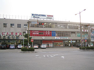
Higashi Okazaki Station
Railway station in Okazaki, Aichi Prefecture, Japan
Distance: Approx. 1471 meters
Latitude and longitude: 34.951858,137.167364
Higashi Okazaki Station (東岡崎駅, Higashi Okazaki-eki) is a railway station in the city of Okazaki, Aichi, Japan, operated by Meitetsu.

Okazakikōen-mae Station
Railway station in Okazaki, Aichi Prefecture, Japan
Distance: Approx. 2402 meters
Latitude and longitude: 34.955,137.153
Okazakikōen-mae Station (岡崎公園前駅, Okazakikōenmae-eki) is a railway station in the city of Okazaki, Aichi, Japan, operated by Meitetsu.

Naka-Okazaki Station
Railway station in Okazaki, Aichi Prefecture, Japan
Distance: Approx. 2346 meters
Latitude and longitude: 34.9562,137.1532
Naka-Okazaki Station (中岡崎駅, Naka-Okazaki-eki) is a railway station in the city of Okazaki, Aichi Prefecture, Japan, operated by the third sector Aichi Loop Railway Company.

Kita-Okazaki Station
Railway station in Okazaki, Aichi Prefecture, Japan
Distance: Approx. 2166 meters
Latitude and longitude: 34.9723,137.158
Kita-Okazaki Station (北岡崎駅, Kita-Okazaki-eki) is a railway station in the city of Okazaki, Aichi Prefecture, Japan, operated by the third sector Aichi Loop Railway Company.

Okazaki Women's Junior College
Distance: Approx. 1020 meters
Latitude and longitude: 34.95508333,137.1856
Okazaki Women's Junior College (岡崎女子短期大学, Okazaki joshi tanki daigaku) is a private women's junior college in the city of Okazaki in Aichi Prefecture, Japan. It was established in 1965.
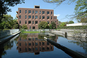
National Institute for Basic Biology, Japan
Distance: Approx. 1776 meters
Latitude and longitude: 34.94972222,137.16527778
The National Institute for Basic Biology (基礎生物学研究所, kisoseibutsugaku kenkyuujo) (NIBB) is a research institute and post graduate university in Okazaki City, Aichi Prefecture, Japan. It was founded in 1977 to promote biological research in Japan in cooperation with public and private universities, and research institutes.

National Institute for Physiological Sciences, Japan
Distance: Approx. 1886 meters
Latitude and longitude: 34.94886111,137.16463889
The National Institute for Physiological Sciences (生理学研究所, Seirigaku kenkyuujo) (NIPS) is an inter-university research institute and part of the National Institute of Natural Sciences, located in the city of Okazaki, Aichi, Japan. It was established in 2004.
Shin-ike Dam
Dam in Aichi Prefecture, Japan
Distance: Approx. 2254 meters
Latitude and longitude: 34.95305556,137.20027778
Shin-ike Dam is an earthfill dam located in Aichi Prefecture in Japan. The dam is used for irrigation. The catchment area of the dam is 0.2 km2.
Weather in this IP's area
overcast clouds
25 Celsius
26 Celsius
25 Celsius
25 Celsius
1011 hPa
66 %
1011 hPa
1005 hPa
10000 meters
1.88 m/s
2.83 m/s
247 degree
95 %
06:00:16
17:11:56