Country:
 New Zealand
Region:
City:
Latitude and Longitude:
Time Zone:
Postal Code:
IP information under different IP Channel
ip-api
Country
Region
City
ASN
Time Zone
ISP
Blacklist
Proxy
Latitude
Longitude
Postal
Route
IPinfo
Country
Region
City
ASN
Time Zone
ISP
Blacklist
Proxy
Latitude
Longitude
Postal
Route
MaxMind
Country
Region
City
ASN
Time Zone
ISP
Blacklist
Proxy
Latitude
Longitude
Postal
Route
Luminati
Country
NZRegion
auk
City
auckland
ASN
Time Zone
Pacific/Auckland
ISP
Two Degrees Networks Limited
Latitude
Longitude
Postal
db-ip
Country
Region
City
ASN
Time Zone
ISP
Blacklist
Proxy
Latitude
Longitude
Postal
Route
ipdata
Country
Region
City
ASN
Time Zone
ISP
Blacklist
Proxy
Latitude
Longitude
Postal
Route
Popular places and events near this IP address

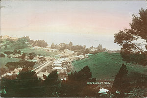
Devonport, New Zealand
Suburb in Auckland, New Zealand
Distance: Approx. 581 meters
Latitude and longitude: -36.831667,174.796278
Devonport ( DEV-ən-port) is a harbourside suburb of Auckland, New Zealand. It is located on the North Shore, at the southern end of the Devonport Peninsula that runs southeast from near Lake Pupuke in Takapuna, forming the northern side of the Waitematā Harbour. East of Devonport lies North Head, the northern promontory guarding the mouth of the harbour.

Mount Victoria (Auckland)
Scoria cone in Auckland, New Zealand
Distance: Approx. 1031 meters
Latitude and longitude: -36.8266,174.799
Takarunga / Mount Victoria is the highest volcano on Auckland's North Shore, rising to 66 metres in elevation. Its age is currently unknown. Its lava flows now line much of Devonport's waterfront.

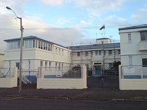
Devonport Naval Base
Main base of the Royal New Zealand Navy in Auckland
Distance: Approx. 384 meters
Latitude and longitude: -36.830241,174.786236
Devonport Naval Base is the home of the Royal New Zealand Navy, located at Devonport, New Zealand on Auckland's North Shore. It is currently the only base of the navy that operates ships, and has been in use as a navy base since 1841. The base consists of HMNZS Philomel (the administration centre for the base), the Fleet Support Organisation, and the Fleet Personnel and Training Organisation.

Stanley Point
Suburb in Auckland, New Zealand
Distance: Approx. 583 meters
Latitude and longitude: -36.827,174.789
Stanley Point (previously Stanley Bay) is a small suburb located on the North Shore of Auckland, New Zealand, near Devonport, another suburb. It is mostly residential. The Devonport Naval Base lies to the east of the bay on the south side of the Stanley Bay peninsula and is connected to storage facilities on the north side at Ngataringa Bay by a tunnel.
North Shore Rugby Football Club
Rugby team
Distance: Approx. 1644 meters
Latitude and longitude: -36.82436706,174.80542977
The North Shore Rugby Football Club is a rugby union club based in Devonport, New Zealand. The club is a member of the North Harbour Rugby Union. Until 1985, with the creation of the North Harbour union, North Shore was a member of the Auckland Rugby Football Union.
Naval Health Unit
Hospital in Auckland, New Zealand
Distance: Approx. 413 meters
Latitude and longitude: -36.82891,174.787642
The Navy Health Unit (previously known as the Navy Hospital or the Royal New Zealand Navy Hospital (RNZNH)) is the healthcare facility of the New Zealand Navy. It is located in Devonport, on Devonport Naval Base in Auckland. The hospital specialises in surgery and hyperbaric treatment.
Auckland Marine Rescue Centre
Distance: Approx. 1642 meters
Latitude and longitude: -36.84693,174.78873
The Auckland Marine Rescue Centre is the control centre for the Coastguard Northern Region and Surf Lifesaving New Zealand's control centre SurfCom. It also houses other marine services such as the Harbourmaster and the Maritime Police. It is located in Mechanics Bay, Auckland, at the eastern end of the Ports of Auckland container terminal.

HMNZS Philomel
Royal New Zealand Navy naval base in Auckland
Distance: Approx. 576 meters
Latitude and longitude: -36.82958,174.78422
HMNZS Philomel is the main administrative base of the Royal New Zealand Navy. Originally a training base on board the cruiser from which it takes its name, it is part of the Devonport Naval Base on the North Shore of Auckland, New Zealand.

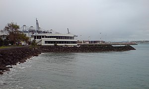
Calliope Dock
Dry Dock in Auckland
Distance: Approx. 384 meters
Latitude and longitude: -36.830241,174.786236
The Calliope Dock is a historical stone dry dock on the grounds of the Devonport Naval Base, in Devonport, Auckland, New Zealand. It was built in 1888 to service ships of the British Royal Navy, and is still in use today. As built it measured 525 ft (160 m) by 110 ft (34 m), narrowing to 80 ft (24 m) at the gate.
Mount Cambria
Mountain in New Zealand
Distance: Approx. 1384 meters
Latitude and longitude: -36.824444,174.801933
Mount Cambria (also Sheep Hill or Taka-a-raro / Takararo) is one of the volcanoes in the Auckland volcanic field. Located in the suburb of Devonport north-east of Mt Victoria, its 30-metre scoria cone was quarried away. The site is now Cambria Reserve.

Duders Hill
Distance: Approx. 1197 meters
Latitude and longitude: -36.830039,174.802949
Duders Hill (also Takamaiiwaho) was a 20 metre high scoria mound located on the Devonport coast, on the lower south-east slopes of Takarunga / Mount Victoria, in the Auckland volcanic field.
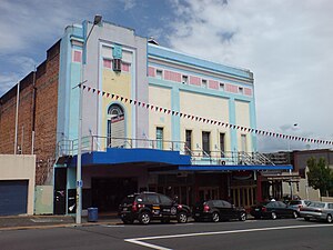
Victoria Theatre, Devonport
Cinema in Auckland, New Zealand
Distance: Approx. 810 meters
Latitude and longitude: -36.82916667,174.79805556
The Victoria Theatre, in Devonport, Auckland, New Zealand, is both the country's and the Southern Hemisphere's oldest surviving purpose-built cinema, dating from 1912. It was extensively refurbished in 2010.
Weather in this IP's area
few clouds
12 Celsius
11 Celsius
10 Celsius
13 Celsius
996 hPa
71 %
996 hPa
996 hPa
10000 meters
5.14 m/s
290 degree
20 %
06:18:11
18:12:50