Country:
Region:
City:
Latitude and Longitude:
Time Zone:
Postal Code:
IP information under different IP Channel
ip-api
Country
Region
City
ASN
Time Zone
ISP
Blacklist
Proxy
Latitude
Longitude
Postal
Route
Luminati
Country
Region
wko
City
hamilton
ASN
Time Zone
Pacific/Auckland
ISP
Two Degrees Networks Limited
Latitude
Longitude
Postal
IPinfo
Country
Region
City
ASN
Time Zone
ISP
Blacklist
Proxy
Latitude
Longitude
Postal
Route
db-ip
Country
Region
City
ASN
Time Zone
ISP
Blacklist
Proxy
Latitude
Longitude
Postal
Route
ipdata
Country
Region
City
ASN
Time Zone
ISP
Blacklist
Proxy
Latitude
Longitude
Postal
Route
Popular places and events near this IP address

Elam School of Fine Arts
Art school at the University of Auckland
Distance: Approx. 299 meters
Latitude and longitude: -36.855469,174.767922
The Elam School of Fine Arts, founded by John Edward Elam, is part of the Faculty of Creative Arts and Industries at the University of Auckland. It offered the first Bachelor of Fine Arts programme in New Zealand starting in 1967. Students study degrees in fine art, across three buildings, the Mondrian building, Building 431 (or the "Main" fine arts building), and Elam B, which includes the studios for postgraduate and doctoral students on Princes Street, in central Auckland, New Zealand.

Myers Park, Auckland
Park and kindergarten in New Zealand
Distance: Approx. 373 meters
Latitude and longitude: -36.855364,174.761217
Myers Park is a narrow park in central Auckland, New Zealand, running parallel to the upper part of Queen Street. It is characterised by steep, grassed slopes and canopied with a mixture of large exotic and native trees, including an alley of large palm trees. A playground, benches, and various artworks are features of the park.

Grafton Bridge
Bridge in Auckland, New Zealand
Distance: Approx. 292 meters
Latitude and longitude: -36.85941111,174.76526389
Grafton Bridge is a road bridge spanning Grafton Gully in Auckland, New Zealand. Built of reinforced concrete in 1910, it connects the Auckland CBD and Karangahape Road with Grafton. It spans about 97.6 metres (320 feet), rises 25.6 metres (84 feet) above the abutments to a height of around 43 metres (141 feet) over the gully.

Grafton Gully
Distance: Approx. 260 meters
Latitude and longitude: -36.858712,174.766678
Grafton Gully is a deep (about 50 m) and very wide (about 100 m) gully running northwards towards the sea through the volcanic hills of the Auckland volcanic field in New Zealand. It divides the CBD from the suburbs of Grafton and Parnell in the east.

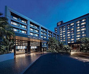
Cordis, Auckland
Hotel in Auckland, New Zealand
Distance: Approx. 233 meters
Latitude and longitude: -36.8578,174.7627
The Cordis Hotel, Auckland is a luxury hotel in Auckland, New Zealand. Formerly named The Langham, Auckland, it occupies the historic site of Partington's Windmill, a local landmark until its demolition in 1950.

Auckland Baptist Tabernacle
Church in Auckland, New Zealand
Distance: Approx. 323 meters
Latitude and longitude: -36.857452,174.761466
The Auckland Baptist Tabernacle is a Baptist church located near the corner of Queen Street and Karangahape Road, at the edge of Auckland central business district in New Zealand. It is affiliated with the Baptist Churches of New Zealand.

Symonds Street
Street in Auckland, New Zealand
Distance: Approx. 126 meters
Latitude and longitude: -36.856,174.766
Symonds Street is a street in Auckland, New Zealand's most populous city. The road runs southwest and uphill from the top of Anzac Avenue (originally Jermyn Street), through the City Campus of University of Auckland, over the Northwestern Motorway and Auckland Southern Motorway and to the start of New North Road and Mount Eden Road.

Symonds Street Cemetery
Cemetery in Auckland, New Zealand
Distance: Approx. 309 meters
Latitude and longitude: -36.8595,174.7642
Symonds Street Cemetery is a historic cemetery and park in central Auckland, New Zealand. It is in 5.8 hectares of deciduous forest on the western slope of Grafton Gully, by the corner of Symonds Street and Karangahape Road, and is crossed by the Grafton Bridge. The street (and by extension, the cemetery) is named for William Cornwallis Symonds, a British Army officer prominent in the early colonisation of New Zealand.

UP International College Auckland
Private school, secondary (year 9–15) school
Distance: Approx. 338 meters
Latitude and longitude: -36.854451,174.762604
ACG New Zealand International College (ACG NZIC) is a private school, owned by the Academic Colleges Group New Zealand. The school's curriculum provides pathways to tertiary study for international students. It has premises in Auckland City, in the central business district.

Auckland Business Chamber
Distance: Approx. 52 meters
Latitude and longitude: -36.8569366,174.765563
The Auckland Business Chamber (known as the Auckland Chamber of Commerce until 2018), is a New Zealand business network representing the interests of businesses in the Auckland region. It is a non-governmental organisation.

AUT Law School
Distance: Approx. 370 meters
Latitude and longitude: -36.85351667,174.76435556
The AUT Law School is a school of Auckland University of Technology in Auckland, New Zealand. The law school is a part of the Faculty of Business, Economics and Law and is one of three schools in the faculty. It offers two undergraduate, and five postgraduate programs to students.

Karangahape Rocks
Public sculpture in New Zealand
Distance: Approx. 255 meters
Latitude and longitude: -36.85849,174.76307
Karangahape Rocks, also known as the Karangahape Road Fountain is a public sculpture located in Pigeon Park on Karangahape Road in Auckland, New Zealand, created by New Zealand sculptor Greer Twiss as his first large-scale public commission. The sculpture, formerly a working fountain, depicts three bronze spherical shapes and two seated figures. Unveiled in 1969, the piece is one of the earliest contemporary public sculptures in Auckland.
Weather in this IP's area
broken clouds
11 Celsius
10 Celsius
9 Celsius
12 Celsius
1021 hPa
80 %
1021 hPa
1013 hPa
10000 meters
2.06 m/s
60 degree
75 %
06:12:34
19:56:24